ISS011-E-9680
| NASA Photo ID | ISS011-E-9680 |
| Focal Length | 180mm |
| Date taken | 2005.06.27 |
| Time taken | 13:03:54 GMT |
1000 x 661 pixels 357 x 540 pixels 540 x 405 pixels 3032 x 2008 pixels 639 x 435 pixels
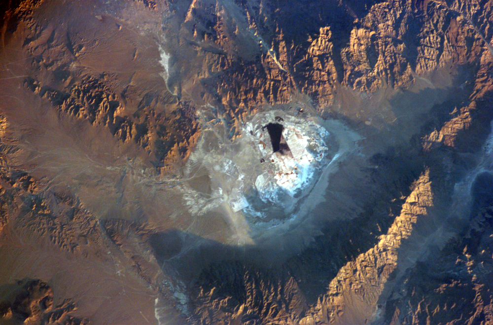
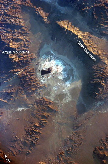
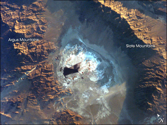
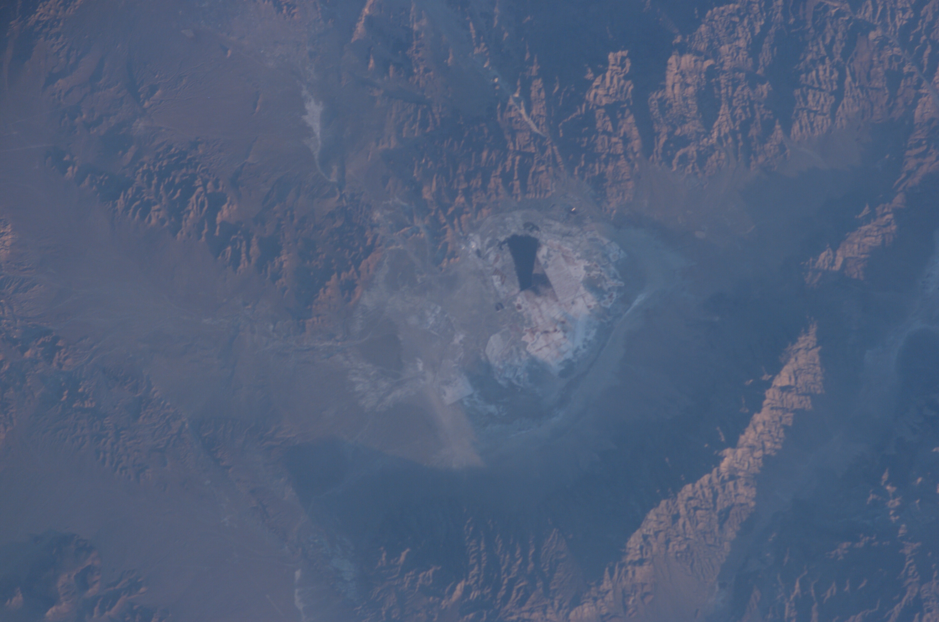
Photo center point: 35.5° N, 117.5° W
Photo center point by machine learning:
Country or Geographic Name: | USA-CALIFORNIA |
Features: | SEARLES LAKE, PLAYA, SLATE RANGE |
| Features Found Using Machine Learning: | |
Cloud Cover Percentage: | 10 (1-10)% |
Sun Elevation Angle: | 4° |
Sun Azimuth: | 64° |
Camera: | Kodak DCS760c Electronic Still Camera |
Focal Length: | 180mm |
Camera Tilt: | 14 degrees |
Format: | 3060E: 3060 x 2036 pixel CCD, RGBG array |
Film Exposure: | |
| Additional Information | |
| Width | Height | Annotated | Cropped | Purpose | Links |
|---|---|---|---|---|---|
| 1000 pixels | 661 pixels | No | Yes | Earth From Space collection | Download Image |
| 357 pixels | 540 pixels | Yes | Yes | Earth From Space collection | Download Image |
| 540 pixels | 405 pixels | Yes | Yes | NASA's Earth Observatory web site | Download Image |
| 3032 pixels | 2008 pixels | No | No | Not enhanced | Download Image |
| 639 pixels | 435 pixels | No | No | Download Image |
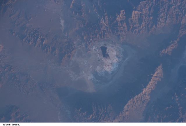
Searles Lake is known for the abundance of rare elements and evaporate minerals, such as trona, hanksite, and halite formed within its sediments. Evaporites are minerals that are left behind when saltwater evaporates. During the Pleistocene Epoch (beginning approximately 2 million years ago), Searles Lake was one of a chain of lakes fed by streamflow from the Sierra Nevada to the west. Lake levels rose and fell dependant on glacial outwash from the Sierra Nevada as climate shifted. Successive layers of sediment were deposited as lake levels fluctuated, preserving an important record of regional climate change. The lakes gradually dried up completely as climatic conditions became hotter and drier (as today), forming a string of playas--enclosed basins with no outlets.
This astronaut photograph depicts the Searles Lake playa (characterized by white surface mineral deposits) bounded by the Argus and Slate Mountains. The width of the playa is approximately 10 kilometers. The center of the image is dominated by mining operations that extract sodium- and potassium-rich minerals (primarily borax and salt) for industrial use. Minerals are primarily found in naturally occurring, subsurface brines, which are pumped to the surface and evaporated to crystallize the minerals. A large evaporation pond (black) is visible in the center of the image. Further processing concentrates the minerals and removes excess water.
