ISS011-E-9620
| NASA Photo ID | ISS011-E-9620 |
| Focal Length | 400mm |
| Date taken | 2005.06.25 |
| Time taken | 23:10:05 GMT |
1000 x 661 pixels 540 x 357 pixels 540 x 334 pixels 3032 x 2008 pixels 639 x 435 pixels

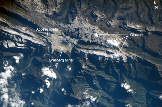


Photo center point: 4.1° S, 137.1° E
Photo center point by machine learning:
Country or Geographic Name: | INDONESIA-WNG |
Features: | SUDIRMAN MTS., GRASBERG MINE |
| Features Found Using Machine Learning: | |
Cloud Cover Percentage: | 10 (1-10)% |
Sun Elevation Angle: | 29° |
Sun Azimuth: | 60° |
Camera: | Kodak DCS760c Electronic Still Camera |
Focal Length: | 400mm |
Camera Tilt: | 6 degrees |
Format: | 3060E: 3060 x 2036 pixel CCD, RGBG array |
Film Exposure: | |
| Additional Information | |
| Width | Height | Annotated | Cropped | Purpose | Links |
|---|---|---|---|---|---|
| 1000 pixels | 661 pixels | No | Yes | Earth From Space collection | Download Image |
| 540 pixels | 357 pixels | Yes | Yes | Earth From Space collection | Download Image |
| 540 pixels | 334 pixels | Yes | Yes | NASA's Earth Observatory web site | Download Image |
| 3032 pixels | 2008 pixels | No | No | Not enhanced | Download Image |
| 639 pixels | 435 pixels | No | No | Download Image |
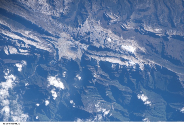
Located in the Sudirman Mountains of the Irian Jaya province of Indonesia, the Grasberg complex (also known as the Freeport Mine) is one of the largest gold and copper mining operations in the world. The Sudirman Mountains form the western portion of the Maoke Range that extends across Irian Jaya from the west to the east-southeast. These ranges were formed by ongoing collision of the northward-moving Australian and westward-moving Pacific tectonic plates. Intrusion of hot magma into sedimentary rock layers during uplift of the mountains resulted in the formation of copper- and gold-bearing ore. The rich copper ore was discovered in the area in 1936, and the Grasberg gold-bearing ore was discovered in 1988.
This astronaut photograph illustrates the approximately 4-kilometer-wide open-pit portion of the mine complex; there are also extensive underground mine workings. Access roads for trucks hauling ore and waste rock are visible along the sides of the pit. The mine is located in close proximity to rare equatorial mountain glaciers that serve as indicators of climate change in the region. Removal of vegetation, steepening of slopes related to mining activities, earthquakes, and frequent heavy rainfall have resulted in deadly landslides in the mine workings. While landscape reclamation projects have begun at the mine, environmental groups and local citizens are concerned with the potential for copper contamination and acid rock drainage into surrounding river systems, land surfaces, and groundwater.
