ISS011-E-11805
| NASA Photo ID | ISS011-E-11805 |
| Focal Length | 800mm |
| Date taken | 2005.08.14 |
| Time taken | 15:56:09 GMT |
1000 x 580 pixels 540 x 313 pixels 540 x 405 pixels 3032 x 2008 pixels 639 x 435 pixels
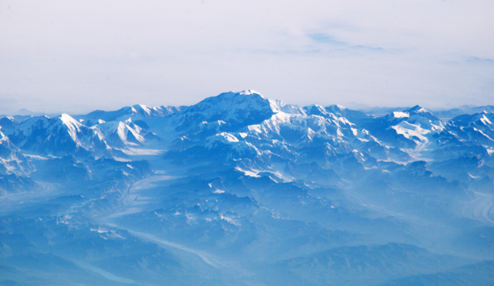
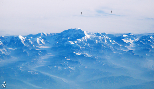
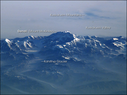

Photo center point: 63.1° N, 151.0° W
Photo center point by machine learning:
Country or Geographic Name: | USA-ALASKA |
Features: | MT. MCKINLEY, ALASKA RA., GL. |
| Features Found Using Machine Learning: | |
Cloud Cover Percentage: | 25 (11-25)% |
Sun Elevation Angle: | 11° |
Sun Azimuth: | 81° |
Camera: | Kodak DCS760c Electronic Still Camera |
Focal Length: | 800mm |
Camera Tilt: | High Oblique |
Format: | 3060E: 3060 x 2036 pixel CCD, RGBG array |
Film Exposure: | |
| Additional Information | |
| Width | Height | Annotated | Cropped | Purpose | Links |
|---|---|---|---|---|---|
| 1000 pixels | 580 pixels | No | Yes | Earth From Space collection | Download Image |
| 540 pixels | 313 pixels | Yes | Yes | Earth From Space collection | Download Image |
| 540 pixels | 405 pixels | Yes | Yes | NASA's Earth Observatory web site | Download Image |
| 3032 pixels | 2008 pixels | No | No | Not enhanced | Download Image |
| 639 pixels | 435 pixels | No | No | Download Image |
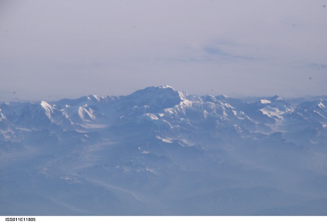
This view of Mt McKinley (Denali)--the highest point in North America (6,194 meters; 20,230 feet)--looks as if it were taken from an aircraft. In fact, an astronaut onboard the International Space Station took advantage of cloud-free skies and a powerful 800-millimeter lens to photograph this peak while the spacecraft was over the Gulf of Alaska, 800 miles to the south of the mountain. The powerful lenses are difficult to use, requiring motion compensation by the astronaut, so these kinds of detailed images of horizon detail are seldom taken. The rising sun casts long shadows across the Kahiltna Glacier that angles down from Denali (left).
In addition to the blueness inherent in all images taken at great distance (the atmosphere scatters blue light more than it does other colors), this image also shows unusually dense atmospheric haze at lower altitudes: all the valleys in the foreground appear murky. The explanation is dramatically portrayed in a Moderate Resolution Imaging Spectroradiometer (MODIS) image taken on the same day, Sunday, August 14, from the Terra satellite. On that day, an enormous smoke pall hung over central Alaska; all the major mountain ranges protruded above the smoke layer, which was held close to the surface by high atmospheric pressure.
The smoke came from more than 100 forest fires burning in the summer heat of Alaska. The MODIS image shows that the smoke on August 14 was far thicker to the north of the Alaska Range where Denali is. The Space Station image shows this denser smoke settled between the Alaska Range and the distant horizon of the Kuskokwim Mountains, 80 miles to the north.
