ISS011-E-11428
| NASA Photo ID | ISS011-E-11428 |
| Focal Length | 400mm |
| Date taken | 2005.07.31 |
| Time taken | 17:38:35 GMT |
1000 x 1260 pixels 540 x 680 pixels 540 x 540 pixels 3032 x 2008 pixels 639 x 435 pixels
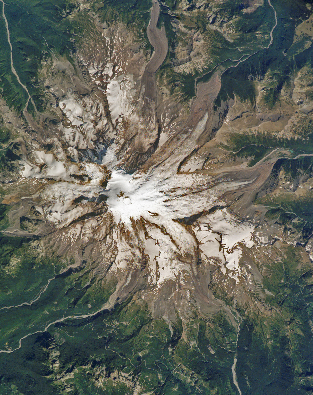
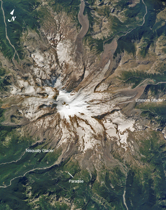
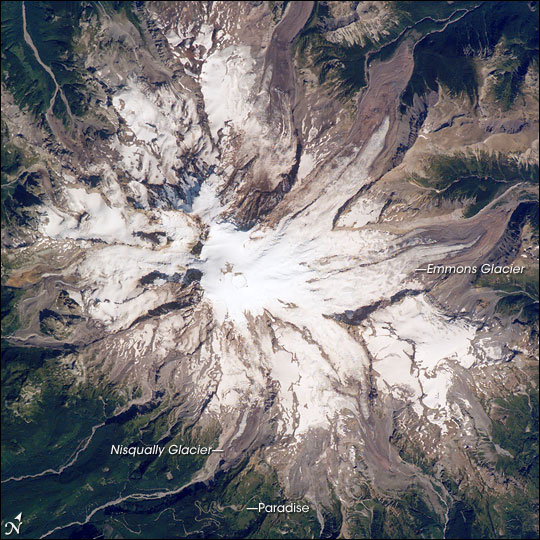
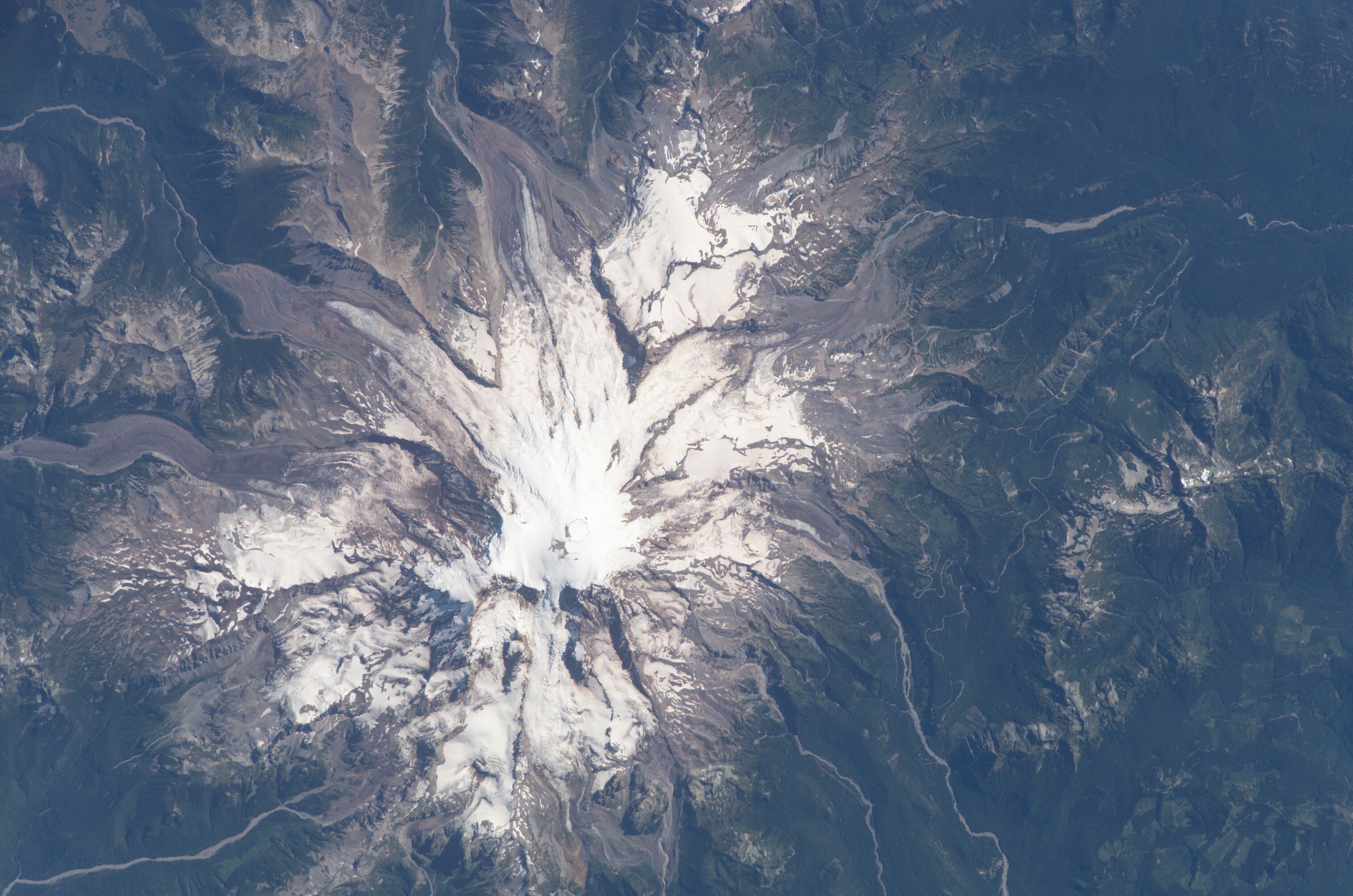
Photo center point: 46.8° N, 121.7° W
Photo center point by machine learning:
Country or Geographic Name: | USA-WASHINGTON |
Features: | MT. RAINIER, SNOW, GL., FOREST |
| Features Found Using Machine Learning: | |
Cloud Cover Percentage: | 10 (1-10)% |
Sun Elevation Angle: | 50° |
Sun Azimuth: | 129° |
Camera: | Kodak DCS760c Electronic Still Camera |
Focal Length: | 400mm |
Camera Tilt: | High Oblique |
Format: | 3060E: 3060 x 2036 pixel CCD, RGBG array |
Film Exposure: | |
| Additional Information | |
| Width | Height | Annotated | Cropped | Purpose | Links |
|---|---|---|---|---|---|
| 1000 pixels | 1260 pixels | No | Yes | Earth From Space collection | Download Image |
| 540 pixels | 680 pixels | Yes | Yes | Earth From Space collection | Download Image |
| 540 pixels | 540 pixels | Yes | Yes | NASA's Earth Observatory web site | Download Image |
| 3032 pixels | 2008 pixels | No | No | Not enhanced | Download Image |
| 639 pixels | 435 pixels | No | No | Download Image |
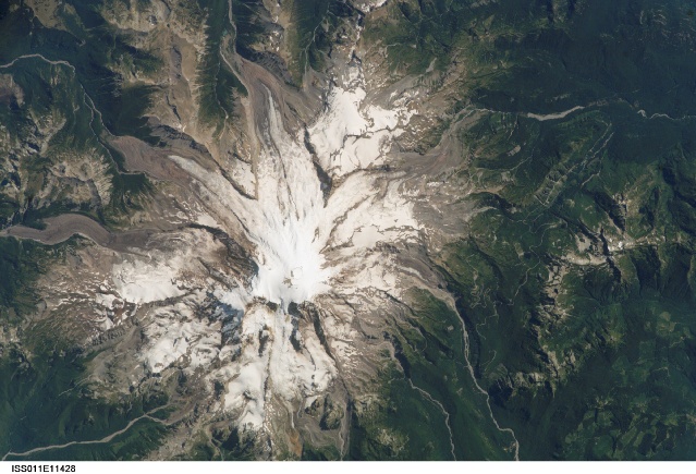
A clear summer day over Washington state provided the International Space Station crew the chance to observe Mt. Rainier--a volcano that overlooks the Seattle metropolitan area and the 2.5 million people who live there. In addition to its presence on the Seattle skyline, Mt. Rainier also looms large among volcanoes in the United States.
It is the highest volcano in the Cascades, with an elevation of 4,392 meters (14,411 feet) above sea level at the summit of the Columbia Crest. Emmons Glacier on the eastern slope is the largest glacier in the lower 48 states. Nisqually Glacier has been actively monitored for more than a century, making it the longest-monitored glacier in the United States. Rainier is an active volcano located next to a large population center, supports several large glaciers, and presents the largest volcanic hazard in the country. While the last recorded eruption of Rainier occurred in 1840, the volcano is continuously monitored by the U.S. Geological Survey's Cascade Volcano Observatory.
This view shows off Rainier's spectacular landforms, including details of the approximately 400-meter-diameter (1,280-foot) summit crater and the glaciers that radiate from the summit. The large debris fields that fill the valleys draining the glaciers comprise one of Rainier's geohazards: potential landslides and debris flows triggered by earthquakes, eruptions, magma-water interactions, or sudden snow or ice melting. Also visible are roads leading to Paradise, an area on the mountain''s south side that provides ready access to trails and spectacular vistas of the glaciers.
