ISS011-E-10258
| NASA Photo ID | ISS011-E-10258 |
| Focal Length | 28mm |
| Date taken | 2005.07.09 |
| Time taken | 22:07:41 GMT |
Cloud masks available for this image:
Spacecraft nadir point: 31.2° N, 87.0° W
Photo center point:
Photo center point by machine learning:
Photo center point:
Photo center point by machine learning:
Nadir to Photo Center:
Spacecraft Altitude: 189 nautical miles (350km)
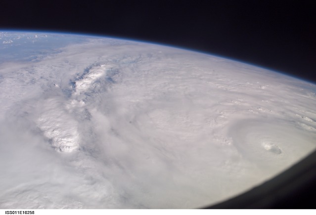
Country or Geographic Name: | GULF OF MEXICO |
Features: | PAN-HURRICANE DENNIS, EYE, BANDS |
| Features Found Using Machine Learning: | PAN- |
Cloud Cover Percentage: | 100 (76-100)% |
Sun Elevation Angle: | 33° |
Sun Azimuth: | 278° |
Camera: | Kodak DCS760c Electronic Still Camera |
Focal Length: | 28mm |
Camera Tilt: | High Oblique |
Format: | 3060E: 3060 x 2036 pixel CCD, RGBG array |
Film Exposure: | |
| Additional Information | |
| Width | Height | Annotated | Cropped | Purpose | Links |
|---|---|---|---|---|---|
| 3032 pixels | 2008 pixels | No | No | Not enhanced | Download Image |
| 639 pixels | 435 pixels | No | No | Download Image |
Download Packaged File
Download a Google Earth KML for this Image
View photo footprint information
Download a GeoTIFF for this photo
Image Caption: ISS011-E-10258 (9 July 2005) --- This easterly-looking image from the International Space Station shows Hurricane Dennis after the storm had already crossed Cuba and was heading for the northern Gulf of Mexico. Dennis was a Category 3 storm, packing winds of 115 miles per hour, at the time of exposure and located approximately 385 miles southeast of Biloxi, Mississippi or 280 miles south of Panama City, Florida. The ill-defined eye is in the lower right corner. The black triangle in extreme lower right is part of the Space Station's window.
