ISS010-E-12929
| NASA Photo ID | ISS010-E-12929 |
| Focal Length | 800mm |
| Date taken | 2005.01.13 |
| Time taken | 10:03:15 GMT |

Cloud masks available for this image:
Spacecraft nadir point: 15.7° N, 81.1° E
Photo center point: 14.4° N, 80.2° E
Photo center point by machine learning:
Photo center point: 14.4° N, 80.2° E
Photo center point by machine learning:
Nadir to Photo Center: Southwest
Spacecraft Altitude: 190 nautical miles (352km)
Camera: | Kodak DCS760c Electronic Still Camera |
Focal Length: | 800mm |
Camera Tilt: | 26 degrees |
Format: | 3060E: 3060 x 2036 pixel CCD, RGBG array |
Film Exposure: | |
| Additional Information | |
| Width | Height | Annotated | Cropped | Purpose | Links |
|---|---|---|---|---|---|
| 3032 pixels | 2064 pixels | No | No | Download Image | |
| 639 pixels | 435 pixels | No | No | Download Image |
Download Packaged File
Download a Google Earth KML for this Image
View photo footprint information
Download a GeoTIFF for this photo
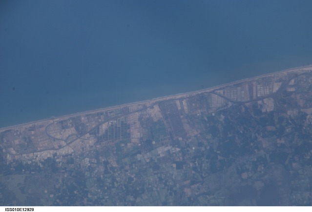
Image Caption: ISS010E12929 (13 January 2005) --- One of a series of post-tsunami digital still images which were photographed from the International Space Station on January 13, 2005. This image is centered at 14.41 degrees north latitude and 80.15 degrees east longitude and is located just south of Chennai (Madras) India. Scientists studying the ISS imagery have discerned a slight discoloration in coastal vegetation, likely caused by the December 2004 tsunami.
