ISS009-E-9985
| NASA Photo ID | ISS009-E-9985 |
| Focal Length | 180mm |
| Date taken | 2004.06.03 |
| Time taken | 12:23:13 GMT |
Resolutions offered for this image:
1000 x 687 pixels 540 x 540 pixels 3032 x 2064 pixels 639 x 435 pixels
1000 x 687 pixels 540 x 540 pixels 3032 x 2064 pixels 639 x 435 pixels

Cloud masks available for this image:
Spacecraft nadir point: 41.4° N, 1.3° E
Photo center point: 40.5° N, 1.0° E
Photo center point by machine learning:
Photo center point: 40.5° N, 1.0° E
Photo center point by machine learning:
Nadir to Photo Center: South
Spacecraft Altitude: 194 nautical miles (359km)
Country or Geographic Name: | SPAIN |
Features: | SUNGLINT, WAVES, EBRO RIVER DELTA |
| Features Found Using Machine Learning: | |
Cloud Cover Percentage: | 10 (1-10)% |
Sun Elevation Angle: | 70° |
Sun Azimuth: | 201° |
Camera: | Kodak DCS760c Electronic Still Camera |
Focal Length: | 180mm |
Camera Tilt: | 16 degrees |
Format: | 3060E: 3060 x 2036 pixel CCD, RGBG array |
Film Exposure: | |
| Additional Information | |
| Width | Height | Annotated | Cropped | Purpose | Links |
|---|---|---|---|---|---|
| 1000 pixels | 687 pixels | No | Yes | Download Image | |
| 540 pixels | 540 pixels | Yes | Yes | NASA's Earth Observatory web site | Download Image |
| 3032 pixels | 2064 pixels | No | No | Download Image | |
| 639 pixels | 435 pixels | No | No | Download Image |
Download Packaged File
Download a Google Earth KML for this Image
View photo footprint information
Download a GeoTIFF for this photo
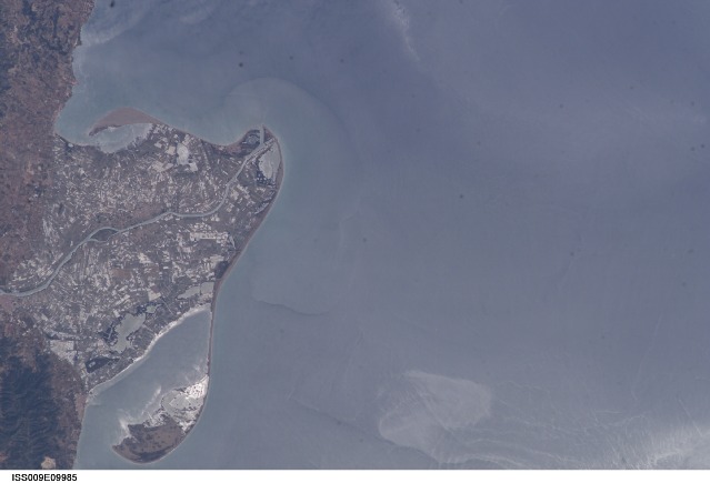
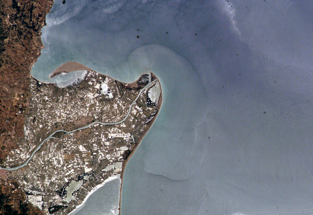
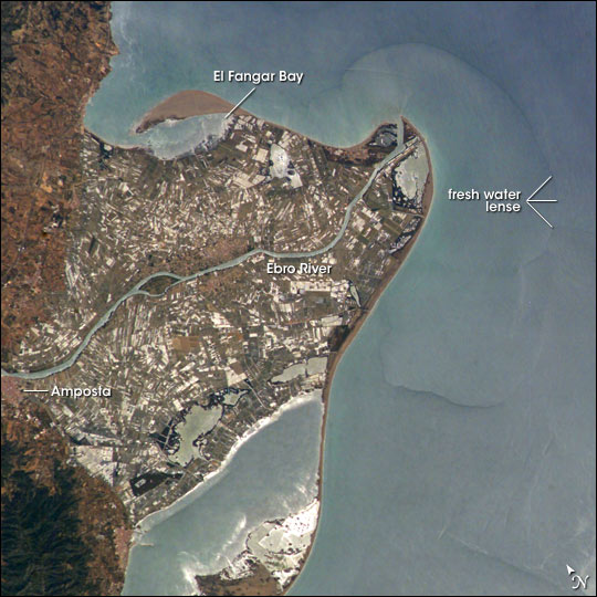
Image Caption: Ebro River Delta, Northeastern Spain:
The Ebro River Delta, located along the eastern coast of Spain, is one of the largest wetland areas (320 km2) in the western Mediterranean region. The Ebro delta has grown rapidly--the historical rate of growth of the delta is demonstrated by the city of Amposta. This city was a seaport in the 4th Century, and is now located well inland from the current Ebro river mouth. The rounded form of the delta attests to the balance between sediment deposition by the Ebro River and removal of this material by wave erosion.
The modern delta is in intensive agricultural use for rice, fruit, and vegetables. White polygonal areas to the north and south of the Ebro River are paddy fields. The Ebro delta also hosts numerous beaches, marshes, and salt pans that provide habitat for over 300 species of birds. A large part of the delta was designated as Parc Natural del Delta de l'Ebre (Ebre Delta National Park) in 1983. A network of canals and irrigation ditches constructed by both agricultural and conservation groups are helping to maintain the ecologic and economic resources of the Ebro Delta.
This astronaut photograph, taken in partial sunglint, also shows the Ebro's fresh water lens--the water density boundary between the upper layer of fresh water issuing from the Ebro River mouth and the saltier, denser Mediterranean Sea water. Diversion and impoundment of the Ebro River upstream has led to a decrease in water and sediment delivery to the delta. This decrease has led to increased erosion in some areas to the northeast of El Fangar Bay and along the southwestern shoreline of the delta.
