ISS009-E-22160
| NASA Photo ID | ISS009-E-22160 |
| Focal Length | 22mm |
| Date taken | 2004.09.11 |
| Time taken | 23:14:19 GMT |
Resolutions offered for this image:
1000 x 600 pixels 540 x 324 pixels 540 x 334 pixels 3032 x 2064 pixels 639 x 435 pixels
1000 x 600 pixels 540 x 324 pixels 540 x 334 pixels 3032 x 2064 pixels 639 x 435 pixels


Cloud masks available for this image:
Spacecraft nadir point: 14.8° N, 85.1° W
Photo center point: 18.2° N, 79.7° W
Photo center point by machine learning:
Photo center point: 18.2° N, 79.7° W
Photo center point by machine learning:
Nadir to Photo Center: Northeast
Spacecraft Altitude: 195 nautical miles (361km)
Country or Geographic Name: | CARIBBEAN SEA |
Features: | PAN-HURRICANE IVAN, BANDS, EYE |
| Features Found Using Machine Learning: | |
Cloud Cover Percentage: | 100 (76-100)% |
Sun Elevation Angle: | 6° |
Sun Azimuth: | 273° |
Camera: | Kodak DCS760c Electronic Still Camera |
Focal Length: | 22mm |
Camera Tilt: | High Oblique |
Format: | 3060E: 3060 x 2036 pixel CCD, RGBG array |
Film Exposure: | |
| Additional Information | |
| Width | Height | Annotated | Cropped | Purpose | Links |
|---|---|---|---|---|---|
| 1000 pixels | 600 pixels | No | Yes | Earth From Space collection | Download Image |
| 540 pixels | 324 pixels | No | Yes | Earth From Space collection | Download Image |
| 540 pixels | 334 pixels | No | Yes | NASA's Earth Observatory web site | Download Image |
| 3032 pixels | 2064 pixels | No | No | Download Image | |
| 639 pixels | 435 pixels | No | No | Download Image |
Download Packaged File
Download a Google Earth KML for this Image
View photo footprint information
Download a GeoTIFF for this photo
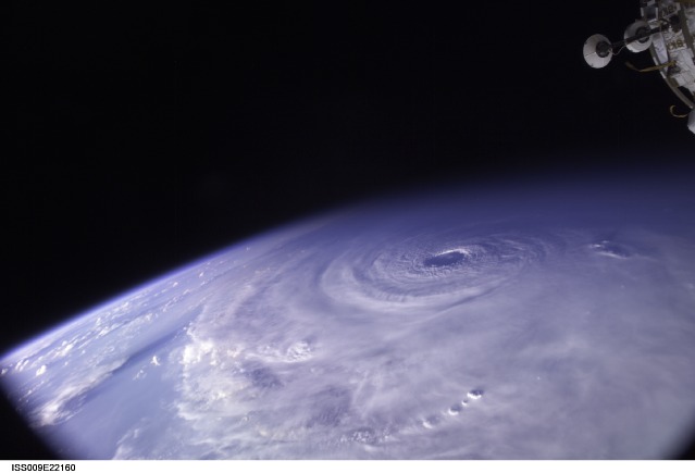
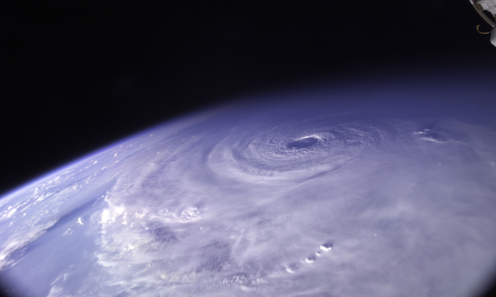
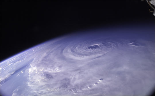
Image Caption: This photo of Hurricane Ivan was snapped as the International Space Station passed over the eye of the storm on Saturday, September 11, 2004, about 15 minutes after 23:00 GMT (7 p.m. EDT). At the time, Ivan was wobbling west off its predicted course, its eye just missing Jamaica. The storm was a powerful and dangerous Category 5 storm with sustained winds reaching to 270 kilometers per hour (165 mph) and higher gusts.
With tropical storm-force winds extending 280 kilometers from the eye, Ivan covers nearly the entire visible portion of the Earth in the above photo (22160). Portions of the ISS hardware (solar arrays) appear in the upper right corner.
With tropical storm-force winds extending 280 kilometers from the eye, Ivan covers nearly the entire visible portion of the Earth in the above photo (22160). Portions of the ISS hardware (solar arrays) appear in the upper right corner.
