ISS009-E-21107
| NASA Photo ID | ISS009-E-21107 |
| Focal Length | 35mm |
| Date taken | 2004.09.01 |
| Time taken | 13:08:51 GMT |

Cloud masks available for this image:
Spacecraft nadir point: 25.7° N, 84.6° W
Photo center point: 21.7° N, 69.8° W
Photo center point by machine learning:
Photo center point: 21.7° N, 69.8° W
Photo center point by machine learning:
Nadir to Photo Center: East
Spacecraft Altitude: 192 nautical miles (356km)
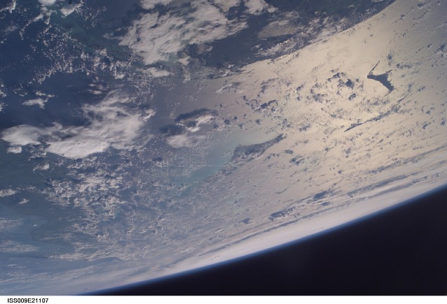
Country or Geographic Name: | ATLANTIC OCEAN |
Features: | PAN-HURRICANE FRANCES, GLINT |
| Features Found Using Machine Learning: | |
Cloud Cover Percentage: | 50 (26-50)% |
Sun Elevation Angle: | 24° |
Sun Azimuth: | 92° |
Camera: | Kodak DCS760c Electronic Still Camera |
Focal Length: | 35mm |
Camera Tilt: | High Oblique |
Format: | 3060E: 3060 x 2036 pixel CCD, RGBG array |
Film Exposure: | |
| Additional Information | |
| Width | Height | Annotated | Cropped | Purpose | Links |
|---|---|---|---|---|---|
| 3032 pixels | 2064 pixels | No | No | Download Image | |
| 639 pixels | 435 pixels | No | No | Download Image |
Download Packaged File
Download a Google Earth KML for this Image
View photo footprint information
Download a GeoTIFF for this photo
Image Caption: ISS009-E-21107 (1 September 2004) --- Astronaut Mike Fincke, aboard the International Space Station at an altitude of about 230 miles, took this photo of Hurricane Frances at about 9 a.m. Sept. 1 as the storm was centered about 800 miles east-southeast of West Palm Beach, Florida. The southern tip of the Florida peninsula and the Bahama islands are visible in the foreground of this image. At the time, Frances was a category 4 hurricane with winds of 140 mph and was moving west-northwest toward a possible landfall in Florida.
