ISS009-E-19682
| NASA Photo ID | ISS009-E-19682 |
| Focal Length | 180mm |
| Date taken | 2004.08.23 |
| Time taken | 16:49:21 GMT |
Resolutions offered for this image:
540 x 540 pixels 1000 x 1415 pixels 3032 x 2064 pixels 639 x 435 pixels
540 x 540 pixels 1000 x 1415 pixels 3032 x 2064 pixels 639 x 435 pixels


Cloud masks available for this image:
Spacecraft nadir point: 9.5° N, 71.2° W
Photo center point: 10.0° N, 71.0° W
Photo center point by machine learning:
Photo center point: 10.0° N, 71.0° W
Photo center point by machine learning:
Nadir to Photo Center: North
Spacecraft Altitude: 191 nautical miles (354km)
Country or Geographic Name: | VENEZUELA |
Features: | LAKE MARACAIBO, GLINT PLATTERNS |
| Features Found Using Machine Learning: | |
Cloud Cover Percentage: | 10 (1-10)% |
Sun Elevation Angle: | 88° |
Sun Azimuth: | 343° |
Camera: | Kodak DCS760c Electronic Still Camera |
Focal Length: | 180mm |
Camera Tilt: | 10 degrees |
Format: | 3060E: 3060 x 2036 pixel CCD, RGBG array |
Film Exposure: | |
| Additional Information | |
| Width | Height | Annotated | Cropped | Purpose | Links |
|---|---|---|---|---|---|
| 540 pixels | 540 pixels | Yes | Yes | Earth From Space collection | Download Image |
| 1000 pixels | 1415 pixels | No | No | Download Image | |
| 3032 pixels | 2064 pixels | No | No | Download Image | |
| 639 pixels | 435 pixels | No | No | Download Image |
Download Packaged File
Download a Google Earth KML for this Image
View photo footprint information
Download a GeoTIFF for this photo
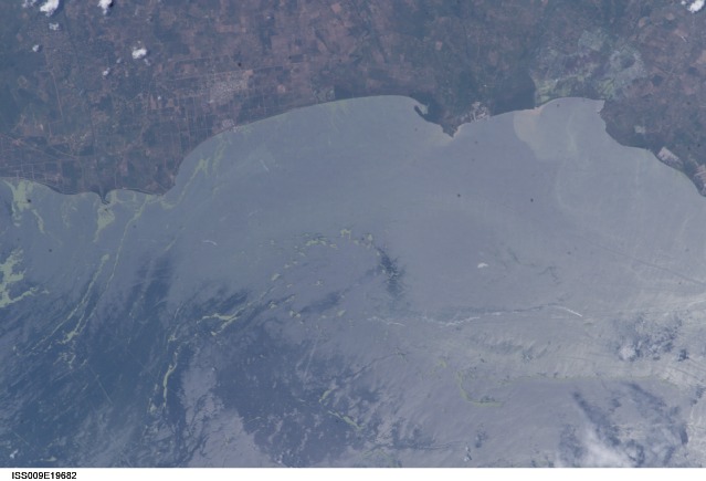
Image Caption: Lake Maracaibo Duck Weed:
Venezuela's Lake Maracaibo presents a complicated surface to interpret. The area is the largest oil producing region in the western hemisphere. Oil platforms and other infrastructure supporting the oil industry can be seen in the lake and along the coast. Oil slicks (very bright streaks) are common. Heavy ship traffic produces linear ship wakes. The vivid green streaks and swirls are patches of duck weed growth that has thrived on the lake this summer. The duck weed problem is so extensive that the Venezuelan government launched a massive campaign to remove it.
This image was taken by astronauts aboard the International Space Station on August 23, 2004. Sunglint--sun light reflecting off the relatively smooth water surface--produces patterns that highlights water surface features and movements. Sunglint reflects brightly off oil slicks, ship wakes and water roughened variably by wind in this image. Rough surfaces like floating vegetation (duck weed) stand out against the smooth water.
An earlier view of the duckweed swirls in Lake Maracaibo was taken by the Moderate Resolution Imaging Spectroradiometer (MODIS).
