ISS009-E-18178
| NASA Photo ID | ISS009-E-18178 |
| Focal Length | 35mm |
| Date taken | 2004.08.13 |
| Time taken | 11:58:05 GMT |

Cloud masks available for this image:
Spacecraft nadir point: 29.6° N, 82.0° W
Photo center point: 24.7° N, 82.9° W
Photo center point by machine learning:
Photo center point: 24.7° N, 82.9° W
Photo center point by machine learning:
Nadir to Photo Center: South
Spacecraft Altitude: 190 nautical miles (352km)
Country or Geographic Name: | GULF OF MEXICO |
Features: | PAN-HURRICANE CHARLEY |
| Features Found Using Machine Learning: | PAN- |
Cloud Cover Percentage: | 75 (51-75)% |
Sun Elevation Angle: | 12° |
Sun Azimuth: | 80° |
Camera: | Kodak DCS760c Electronic Still Camera |
Focal Length: | 35mm |
Camera Tilt: | High Oblique |
Format: | 3060E: 3060 x 2036 pixel CCD, RGBG array |
Film Exposure: | |
| Additional Information | |
| Width | Height | Annotated | Cropped | Purpose | Links |
|---|---|---|---|---|---|
| 3032 pixels | 2064 pixels | No | No | Download Image | |
| 639 pixels | 435 pixels | No | No | Download Image |
Download Packaged File
Download a Google Earth KML for this Image
View photo footprint information
Download a GeoTIFF for this photo
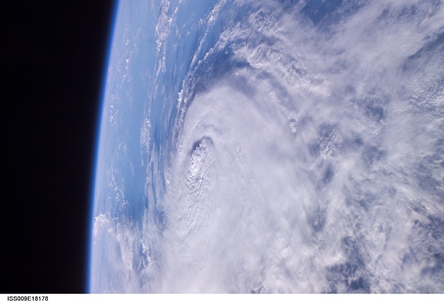
Image Caption: Hurricane Charley:
August 13, 2004 11:58:05 GMT - This panoramic view of Hurricane Charley was photographed by the Expedition 9 crew of the International Space Station earlier this morning at a vantage point just north of Tampa, Florida looking southward. At 9 a.m. (EDT), about an hour after this photo was taken, Charley was reported to be about 75 west of Key West, moving north at 18 mph. Peak winds were estimated to be 110 mph. The small eye was not visible in this view, but the raised cloud tops near the center coincide roughly with the time that the storm began to rapidly strengthen today.
August 13, 2004 11:58:05 GMT - This panoramic view of Hurricane Charley was photographed by the Expedition 9 crew of the International Space Station earlier this morning at a vantage point just north of Tampa, Florida looking southward. At 9 a.m. (EDT), about an hour after this photo was taken, Charley was reported to be about 75 west of Key West, moving north at 18 mph. Peak winds were estimated to be 110 mph. The small eye was not visible in this view, but the raised cloud tops near the center coincide roughly with the time that the storm began to rapidly strengthen today.
