ISS009-E-18129
| NASA Photo ID | ISS009-E-18129 |
| Focal Length | 35mm |
| Date taken | 2004.08.12 |
| Time taken | 21:08:57 GMT |

Cloud masks available for this image:
Spacecraft nadir point: 26.8° N, 86.0° W
Photo center point: 21.0° N, 82.0° W
Photo center point by machine learning:
Photo center point: 21.0° N, 82.0° W
Photo center point by machine learning:
Nadir to Photo Center: Southeast
Spacecraft Altitude: 189 nautical miles (350km)
Country or Geographic Name: | CUBA |
Features: | PAN-HURRICANE CHARLEY |
| Features Found Using Machine Learning: | PAN- |
Cloud Cover Percentage: | 100 (76-100)% |
Sun Elevation Angle: | 42° |
Sun Azimuth: | 266° |
Camera: | Kodak DCS760c Electronic Still Camera |
Focal Length: | 35mm |
Camera Tilt: | High Oblique |
Format: | 3060E: 3060 x 2036 pixel CCD, RGBG array |
Film Exposure: | |
| Additional Information | |
| Width | Height | Annotated | Cropped | Purpose | Links |
|---|---|---|---|---|---|
| 3032 pixels | 2064 pixels | No | No | Download Image | |
| 639 pixels | 435 pixels | No | No | Download Image |
Download Packaged File
Download a Google Earth KML for this Image
View photo footprint information
Download a GeoTIFF for this photo
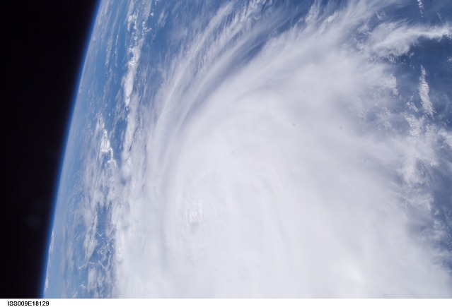
Image Caption: Hurricane Charley:
August 12, 2004 21:08:57 GMT - Less than a minute after ISS009-E-18123, the Expedition 9 crew captured this more detailed view of Hurricane Charley looking southward. The small eye is visible, but not cloud-free yet. Spiraling streaks of high cirrus clouds around the south southern and western edges of the storm indicate the pronounced outflow of air above the storm.
August 12, 2004 21:08:57 GMT - Less than a minute after ISS009-E-18123, the Expedition 9 crew captured this more detailed view of Hurricane Charley looking southward. The small eye is visible, but not cloud-free yet. Spiraling streaks of high cirrus clouds around the south southern and western edges of the storm indicate the pronounced outflow of air above the storm.
