ISS009-E-15488
| NASA Photo ID | ISS009-E-15488 |
| Focal Length | 180mm |
| Date taken | 2004.07.20 |
| Time taken | 18:07:40 GMT |
540 x 312 pixels 1000 x 581 pixels 3032 x 2064 pixels 639 x 435 pixels

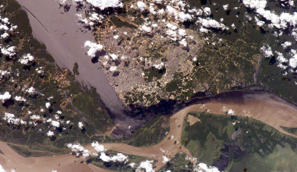

Photo center point: 3.0° S, 60.0° W
Photo center point by machine learning:
Country or Geographic Name: | BRAZIL |
Features: | MANAUS, AMAZON NEGRO CONFLUEN |
| Features Found Using Machine Learning: | |
Cloud Cover Percentage: | 25 (11-25)% |
Sun Elevation Angle: | 51° |
Sun Azimuth: | 308° |
Camera: | Kodak DCS760c Electronic Still Camera |
Focal Length: | 180mm |
Camera Tilt: | 24 degrees |
Format: | 3060E: 3060 x 2036 pixel CCD, RGBG array |
Film Exposure: | |
| Additional Information | |
| Width | Height | Annotated | Cropped | Purpose | Links |
|---|---|---|---|---|---|
| 540 pixels | 312 pixels | Yes | Yes | Earth From Space collection | Download Image |
| 1000 pixels | 581 pixels | No | Yes | NASA's Earth Observatory web site | Download Image |
| 3032 pixels | 2064 pixels | No | No | Download Image | |
| 639 pixels | 435 pixels | No | No | Download Image |
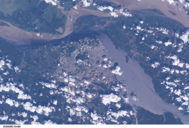
The largest river on the planet, the Amazon, forms from the confluence of the Solimoes (the upper Amazon River) and the Negro at the Brazilian city of Manaus in central Amazonas. At the river conjunction, the muddy, tan-colored waters of the Solimoes meet the "black" water of the Negro River. The unique mixing zone where the waters meet extends downstream through the rainforest for hundreds of kilometers, and is a famous attraction for tourists from all over the world. The tourism contributes to substantial growth in the city of Manaus. Twenty years ago the large park near the city center (center) lay on the eastern outskirts of Manaus.
It is the vast quantity of sediment eroded from the Andes Mountains that gives the Solimoes its tan color. By comparison, water in the Negro derives from the low jungles where reduced physical erosion of rock precludes mud entering the river. In place of sediment, organic matter from the forest floor stains the river the color of black tea.
The Solimoes provides nutrient-rich mud to lakes on the floodplain (lower right). The ecology of muddy lakes differs correspondingly from that of nutrient-poor, blackwater rivers and lakes. Solimoes water can be seen leaking into the Negro west of the main meeting zone (lower left). The Solimoes is much shallower than the Negro because it has filled its valley and bed with great quantities of sediment since the valleys were excavated. Indeed, widths of the rivers differ for this reason (the Negro River is almost 20 km wide in the top left corner).
