ISS009-E-10382
| NASA Photo ID | ISS009-E-10382 |
| Focal Length | 180mm |
| Date taken | 2004.06.07 |
| Time taken | 17:14:09 GMT |
Resolutions offered for this image:
1000 x 1513 pixels 540 x 540 pixels 3032 x 2064 pixels 639 x 435 pixels
1000 x 1513 pixels 540 x 540 pixels 3032 x 2064 pixels 639 x 435 pixels

Cloud masks available for this image:
Spacecraft nadir point: 33.1° N, 110.1° W
Photo center point: 32.0° N, 111.0° W
Photo center point by machine learning:
Photo center point: 32.0° N, 111.0° W
Photo center point by machine learning:
Nadir to Photo Center: Southwest
Spacecraft Altitude: 195 nautical miles (361km)
Country or Geographic Name: | USA-ARIZONA |
Features: | TUCSON, SANTA CRUZ R., MTS. |
| Features Found Using Machine Learning: | |
Cloud Cover Percentage: | 10 (1-10)% |
Sun Elevation Angle: | 61° |
Sun Azimuth: | 102° |
Camera: | Kodak DCS760c Electronic Still Camera |
Focal Length: | 180mm |
Camera Tilt: | 24 degrees |
Format: | 3060E: 3060 x 2036 pixel CCD, RGBG array |
Film Exposure: | |
| Additional Information | |
| Width | Height | Annotated | Cropped | Purpose | Links |
|---|---|---|---|---|---|
| 1000 pixels | 1513 pixels | No | Yes | Download Image | |
| 540 pixels | 540 pixels | Yes | Yes | NASA's Earth Observatory web site | Download Image |
| 3032 pixels | 2064 pixels | No | No | Download Image | |
| 639 pixels | 435 pixels | No | No | Download Image |
Download Packaged File
Download a Google Earth KML for this Image
View photo footprint information
Download a GeoTIFF for this photo
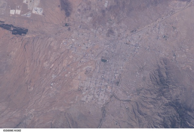
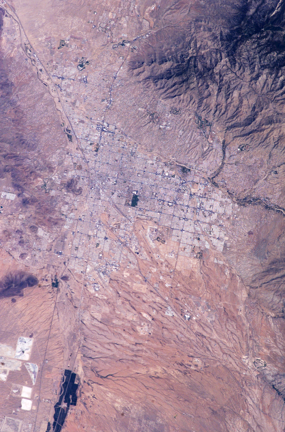
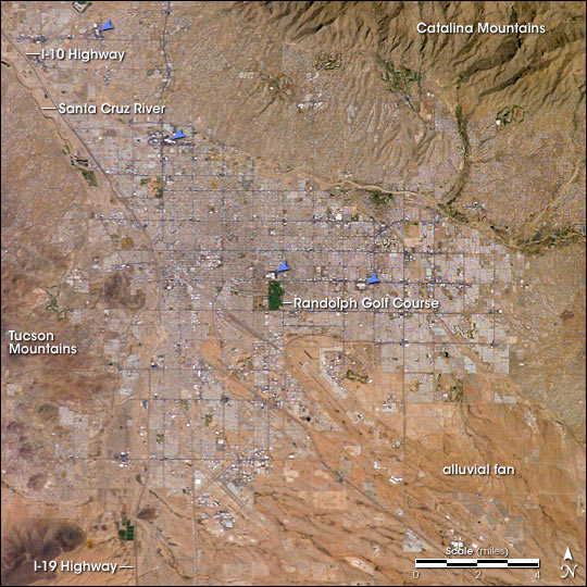
Image Caption: Tucson, Arizona:
Tucson lies between the forested Catalina Mountains and the Tucson Mountains (dark reddish brown at the left image margin).The typical western North American cityscape is a pattern of regular north-south aligned rectangles outlined by major streets set one mile apart. Tucson's Randolph golf course is the large, rectangular dark zone in the image center. The striking contrast between the golf course and its surroundings is due to dense grass cover maintained by frequent watering. Population growth in Tucson is not as rapid as that of Phoenix to the north, however it is still significant. Within the city limits, the population in the year 2000 was about 487,000 and was estimated to be over 514,000 in 2003.
The rectangular grid pattern disappears in the small streets of the original city center, situated along the Santa Cruz River (enters the view at lower left and exits in the top left corner). Moist air from Mexico and the Gulf of California frequently travels northwards along the Santa Cruz River corridor during the summer months. This moisture results in "monsoon" thunderstorms that help recharge the aquifers providing the majority of Tucson's water.
Newer and less densely built-up neighborhoods in the foothills of the Catalina Mountains are designed to incorporate natural landscape features, and retain major washes with natural vegetation. This portion of the cityscape seen from space is consequently quite different from the main city grid. The foothills afford views of the city to the south and the mountains to the north and are major areas of development. Large white dots within the urban grid (blue arrows) are the reflective rooftops of shopping malls.
Tucson enjoys an important position along several major crossroads. Interstate highway I-10, which connects southern California to Florida, appears as a straight line running parallel with the Santa Cruz River northwest from Tucson in the direction of Phoenix. I-10 traverses a well-marked alluvial fan that extends from the Santa Rita Mountains to the southeast (fine drainage pattern lower center of the view) and exits the view at lower right. Highway I-19 is the straight line (lower left) leading south from the city center, between the Santa Cruz River and rectangular spoil heaps of nearby copper mines. I-19 connects Tucson with Nogales on the Mexican border.
