ISS008-E-9603
| NASA Photo ID | ISS008-E-9603 |
| Focal Length | 800mm |
| Date taken | 2003.12.20 |
| Time taken | 10:36:00 GMT |
Resolutions offered for this image:
2000 x 1311 pixels 540 x 334 pixels 1000 x 656 pixels 1000 x 656 pixels 540 x 354 pixels 2000 x 1368 pixels 2000 x 1312 pixels 639 x 437 pixels
2000 x 1311 pixels 540 x 334 pixels 1000 x 656 pixels 1000 x 656 pixels 540 x 354 pixels 2000 x 1368 pixels 2000 x 1312 pixels 639 x 437 pixels


Cloud masks available for this image:
Spacecraft nadir point: 43.3° N, 44.5° E
Photo center point: 43.5° N, 44.0° E
Photo center point by machine learning:
Photo center point: 43.5° N, 44.0° E
Photo center point by machine learning:
Nadir to Photo Center: West
Spacecraft Altitude: 199 nautical miles (369km)
Country or Geographic Name: | RUSSIAN FEDERATION |
Features: | ARGUDAN, AGRICULTURE, FOREST, SNOW |
| Features Found Using Machine Learning: | |
Cloud Cover Percentage: | 0 (no clouds present) |
Sun Elevation Angle: | 20° |
Sun Azimuth: | 204° |
Camera: | Nikon D1 Electronic Still Camera |
Focal Length: | 800mm |
Camera Tilt: | 9 degrees |
Format: | 2000E: 2000 x 1312 pixel CCD, RGBG imager color filter |
Film Exposure: | |
| Additional Information | |
| Width | Height | Annotated | Cropped | Purpose | Links |
|---|---|---|---|---|---|
| 2000 pixels | 1311 pixels | No | No | Earth From Space collection | Download Image |
| 540 pixels | 334 pixels | No | Earth From Space collection | Download Image | |
| 1000 pixels | 656 pixels | No | No | NASA's Earth Observatory web site | Download Image |
| 1000 pixels | 656 pixels | No | NASA's Earth Observatory web site | Download Image | |
| 540 pixels | 354 pixels | No | No | NASA's Earth Observatory web site | Download Image |
| 2000 pixels | 1368 pixels | No | No | Download Image | |
| 2000 pixels | 1312 pixels | No | No | Original file from camera | Download Image |
| 639 pixels | 437 pixels | No | No | Download Image |
Download Packaged File
Download a Google Earth KML for this Image
View photo footprint information
Download a GeoTIFF for this photo
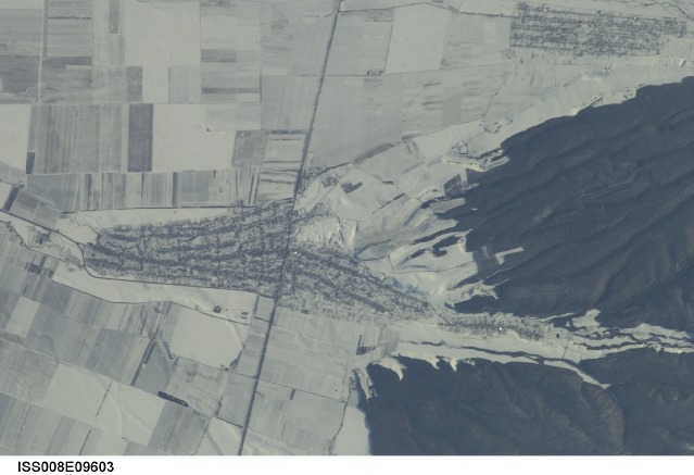
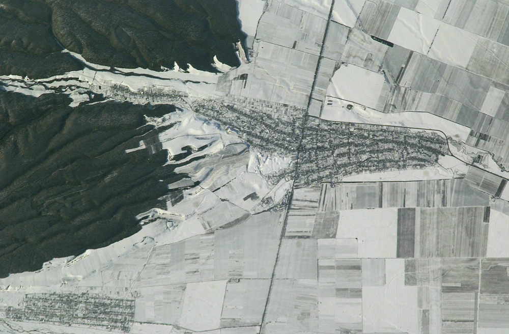
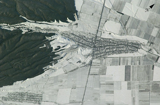
Image Caption: Argudan, Caucasus Mts., Russian Federation:
The striking land use pattern, seen through a high magnification lens and highlighted by winter snow and low Sun angles, produces a unique view of the village of Argudan near the north slopes of the Greater Caucasus Mountains. The image was taken with a handheld camera from the International Space Station in the early afternoon of December 20, 2003. This rural, agricultural community sits astride the main highway about 15 km east-southeast of the city of Nalchik. Shadows from a line of trees planted as a windbreak near the highway give the road a ragged appearance. A small stream flowing northeastward exits heavily forested foothills through the village and fields of intensely cultivated croplands on the plains. Snow falls through the vegetation, making the woodlands appear extremely dark compared to the snow-covered fields. Astronauts also photographed nearby Nalchik, a tourist resort and industrial center. It is the major city of the Kabardino-Balkar Republic (population ~ 750,000), one of five small republics on the north slopes of the Caucasus Mountains, 200 km west of Chechnya.
The striking land use pattern, seen through a high magnification lens and highlighted by winter snow and low Sun angles, produces a unique view of the village of Argudan near the north slopes of the Greater Caucasus Mountains. The image was taken with a handheld camera from the International Space Station in the early afternoon of December 20, 2003. This rural, agricultural community sits astride the main highway about 15 km east-southeast of the city of Nalchik. Shadows from a line of trees planted as a windbreak near the highway give the road a ragged appearance. A small stream flowing northeastward exits heavily forested foothills through the village and fields of intensely cultivated croplands on the plains. Snow falls through the vegetation, making the woodlands appear extremely dark compared to the snow-covered fields. Astronauts also photographed nearby Nalchik, a tourist resort and industrial center. It is the major city of the Kabardino-Balkar Republic (population ~ 750,000), one of five small republics on the north slopes of the Caucasus Mountains, 200 km west of Chechnya.
