ISS008-E-6565
| NASA Photo ID | ISS008-E-6565 |
| Focal Length | 80mm |
| Date taken | 2003.11.30 |
| Time taken | 21:32:40 GMT |

Cloud masks available for this image:
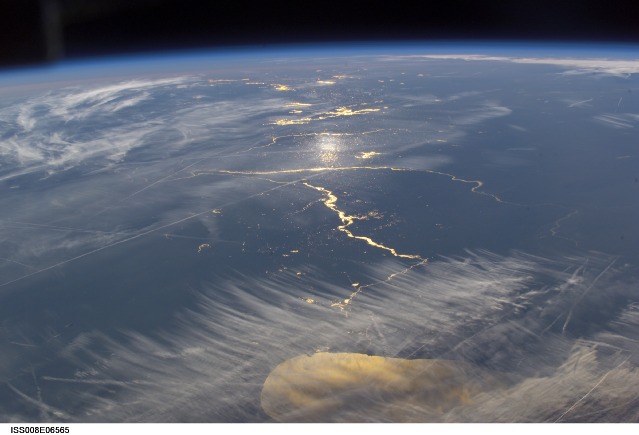
Spacecraft nadir point: 44.9° N, 81.6° W
Photo center point: 40.5° N, 90.0° W
Photo center point by machine learning:
Photo center point: 40.5° N, 90.0° W
Photo center point by machine learning:
Nadir to Photo Center: Southwest
Spacecraft Altitude: 200 nautical miles (370km)
Country or Geographic Name: | USA-ILLINOIS |
Features: | PAN-LAKE MICHIGAN, RIVERS, SUNGLINT |
| Features Found Using Machine Learning: | PAN- |
Cloud Cover Percentage: | 50 (26-50)% |
Sun Elevation Angle: | 1° |
Sun Azimuth: | 237° |
Camera: | Kodak DCS760c Electronic Still Camera |
Focal Length: | 80mm |
Camera Tilt: | High Oblique |
Format: | 3060E: 3060 x 2036 pixel CCD, RGBG array |
Film Exposure: | |
| Additional Information | |
| Width | Height | Annotated | Cropped | Purpose | Links |
|---|---|---|---|---|---|
| 3032 pixels | 2064 pixels | No | No | Download Image | |
| 639 pixels | 435 pixels | No | No | Download Image |
Download Packaged File
Download a Google Earth KML for this Image
View photo footprint information
Download a GeoTIFF for this photo
Image Caption: ISS008-E-06565 (30 November 2003) --- This view featuring the Lake Michigan area was photographed by an Expedition 8 crewmember on the International Space Station (ISS). The photo also shows Chicago area; Illinois River; Mississippi and Missouri Rivers meeting at St. Louis. Aircraft contrails are also visible.
