ISS007-E-5366

| NASA Photo ID | ISS007-E-5366 |
| Focal Length | 50mm |
| Date taken | 2003.05.11 |
| Time taken | 00:19:28 GMT |
Resolutions offered for this image:
540 x 335 pixels 998 x 619 pixels 540 x 402 pixels 1000 x 621 pixels 540 x 851 pixels 3032 x 2064 pixels 6144 x 4068 pixels 639 x 435 pixels
540 x 335 pixels 998 x 619 pixels 540 x 402 pixels 1000 x 621 pixels 540 x 851 pixels 3032 x 2064 pixels 6144 x 4068 pixels 639 x 435 pixels


Cloud masks available for this image:
Spacecraft nadir point: 14.8° N, 141.8° E
Photo center point: 16.5° N, 145.5° E
Photo center point by machine learning:
Photo center point: 16.5° N, 145.5° E
Photo center point by machine learning:
Nadir to Photo Center: East
Spacecraft Altitude: 209 nautical miles (387km)
Country or Geographic Name: | NORTHERN MARIANA IS. |
Features: | VOLCANIC ERUPTION ON ANATAHAN |
| Features Found Using Machine Learning: | |
Cloud Cover Percentage: | 25 (11-25)% |
Sun Elevation Angle: | 59° |
Sun Azimuth: | 80° |
Camera: | Kodak DCS760c Electronic Still Camera |
Focal Length: | 50mm |
Camera Tilt: | 49 degrees |
Format: | 3060E: 3060 x 2036 pixel CCD, RGBG array |
Film Exposure: | |
| Additional Information | |
| Width | Height | Annotated | Cropped | Purpose | Links |
|---|---|---|---|---|---|
| 540 pixels | 335 pixels | Photographic Highlights | Download Image | ||
| 998 pixels | 619 pixels | Photographic Highlights | Download Image | ||
| 540 pixels | 402 pixels | Yes | Earth From Space collection | Download Image | |
| 1000 pixels | 621 pixels | No | No | NASA's Earth Observatory web site | Download Image |
| 540 pixels | 851 pixels | Yes | Yes | NASA's Earth Observatory web site | Download Image |
| 3032 pixels | 2064 pixels | No | No | Download Image | |
| 6144 pixels | 4068 pixels | No | No | Presentation | Download Image |
| 639 pixels | 435 pixels | No | No | Download Image |
Download Packaged File
Download a Google Earth KML for this Image
View photo footprint information
Download a GeoTIFF for this photo
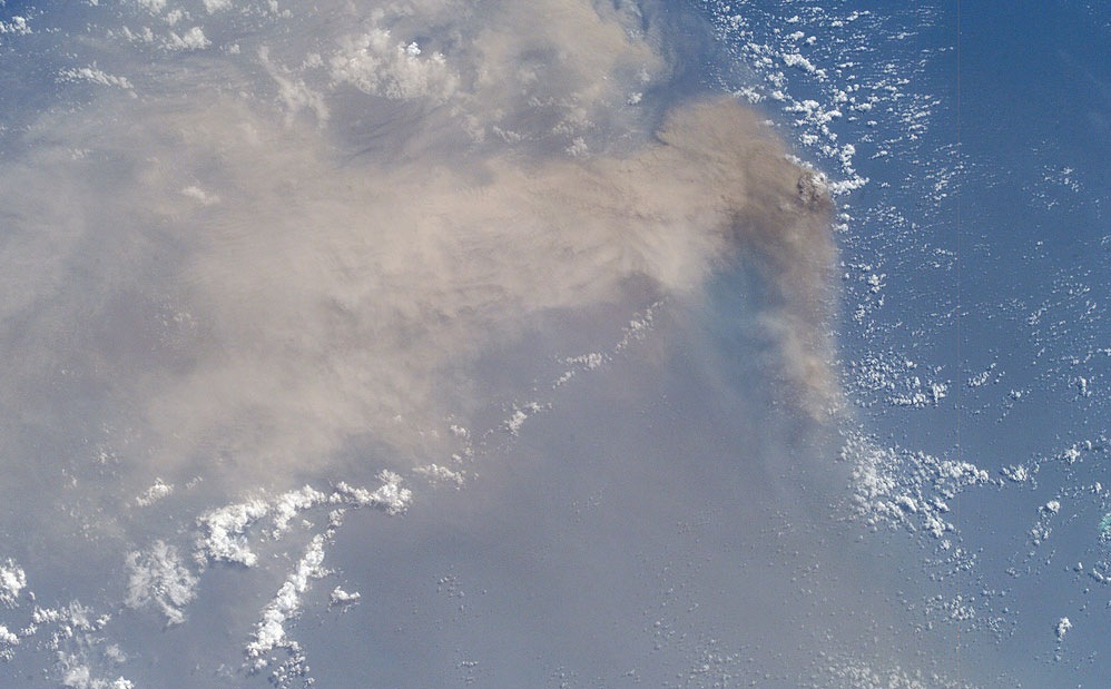
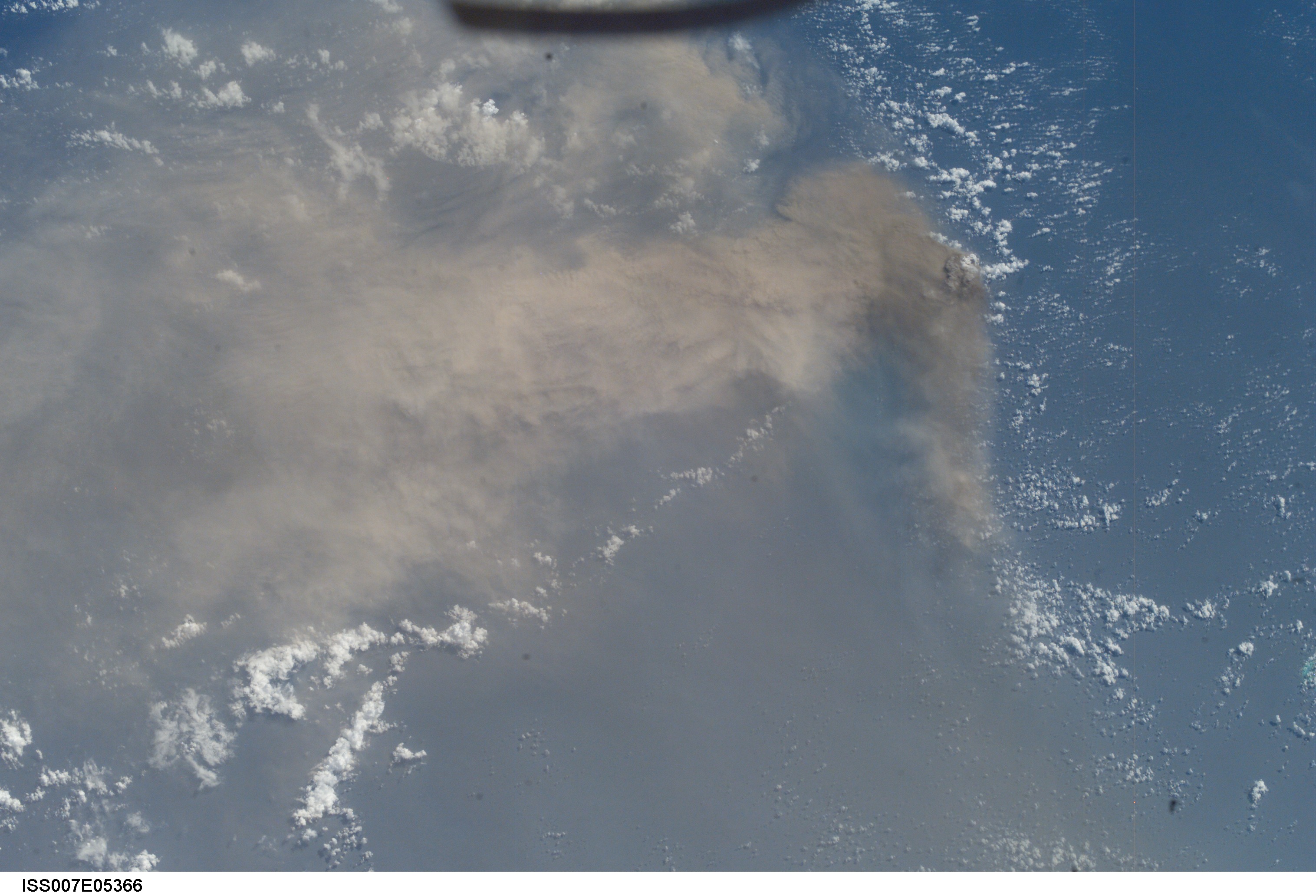
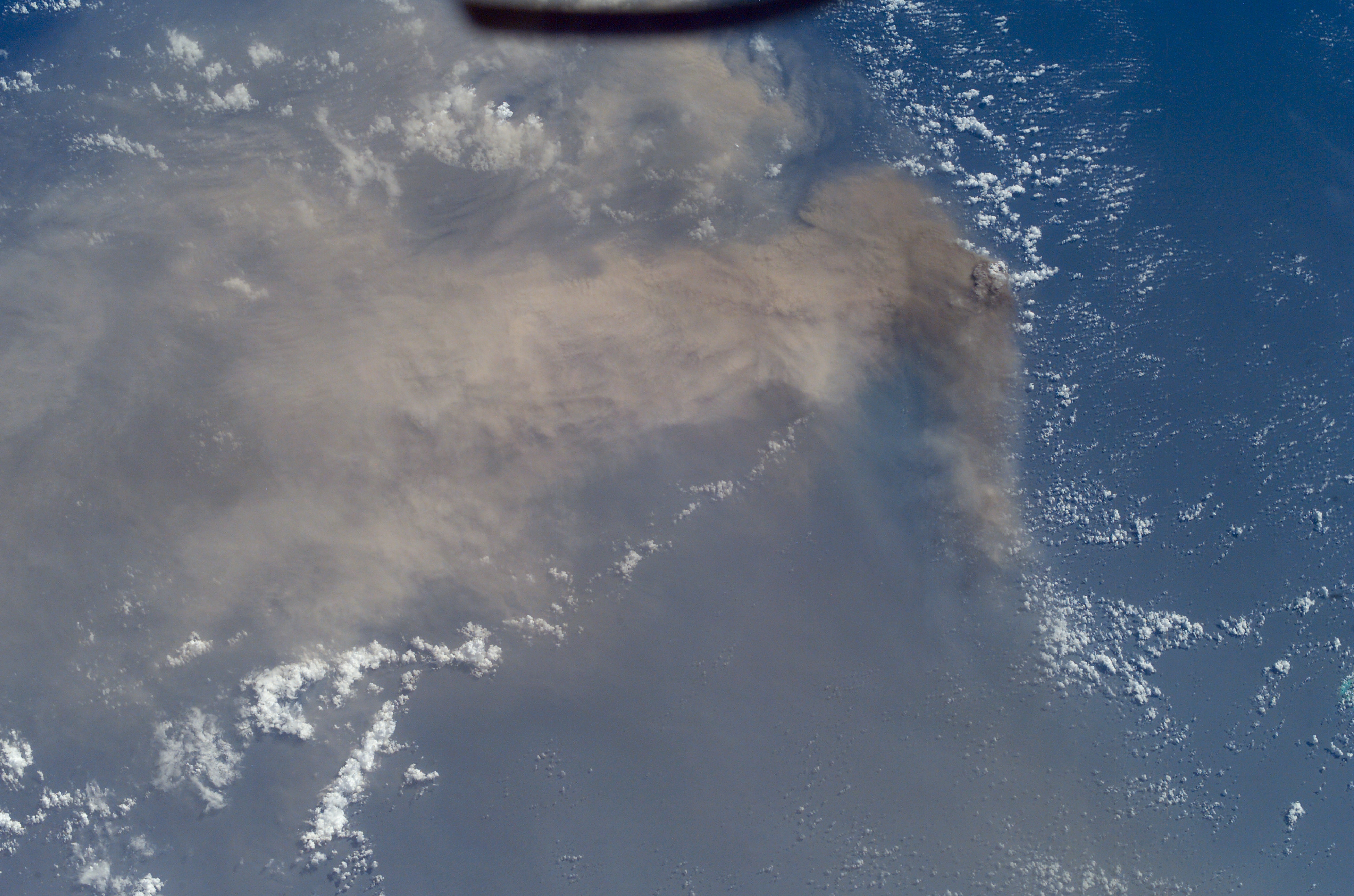
Image Caption: It is sleep time on the International Space Station, and astronaut Ed Lu is supposed to be asleep. He is looking out the window and admiring the Pacific Ocean below. Suddenly he realizes something is strange. A huge yellowish-brown plume is sweeping across hundreds of miles of ocean. A major volcanic eruption is in progress--he grabs a camera and shoots.
Space Station crewmembers receive a daily list of photographic targets that include areas of scientific interest and dynamic events. In this case, though, the crew observed the eruption before news had spread to the international media or to the networks that track volcanic events worldwide. Ed checked with NASA Cap Com to find out whether it really was a volcano and precisely where the eruption was occurring.
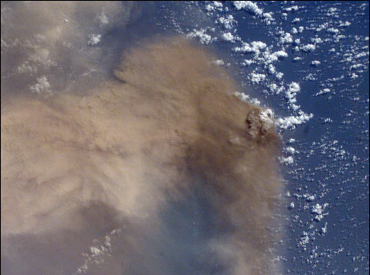
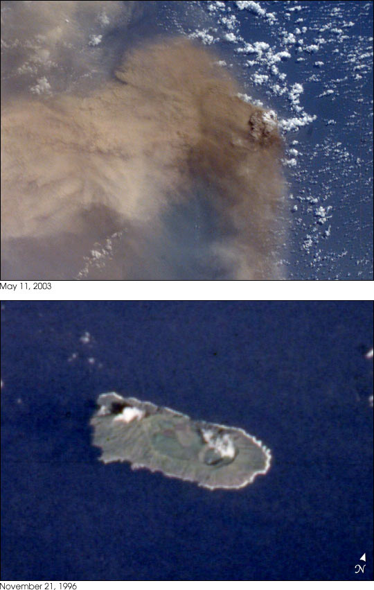
The eruption was from the volcano on Anatahan Island, which is located 80 miles north of Saipan and is part of the Northern Mariana Island Chain. This small island, 6 miles long by 2 miles wide, has been uninhabited since 1990 when residents were evacuated because of a strong earthquake. The lower photograph shows how Anatahan looked from the Space Shuttle in 1996 (photo STS080-707-28).
On the night of May 10, the Anatahan Volcano announced itself with a vigorous eruption that sent high-level ash over a wide area. About 12 hours later, on May 11 at 00:19 GMT, the crew of the International Space Station observed and photographed this ash plume, describing it as huge. By May 15 a state of emergency had been declared in the Northern Mariana Islands as the eruption appeared to be intensifying.
Space Station crewmembers receive a daily list of photographic targets that include areas of scientific interest and dynamic events. In this case, though, the crew observed the eruption before news had spread to the international media or to the networks that track volcanic events worldwide. Ed checked with NASA Cap Com to find out whether it really was a volcano and precisely where the eruption was occurring.
The eruption was from the volcano on Anatahan Island, which is located 80 miles north of Saipan and is part of the Northern Mariana Island Chain. This small island, 6 miles long by 2 miles wide, has been uninhabited since 1990 when residents were evacuated because of a strong earthquake. The lower photograph shows how Anatahan looked from the Space Shuttle in 1996 (photo STS080-707-28).
On the night of May 10, the Anatahan Volcano announced itself with a vigorous eruption that sent high-level ash over a wide area. About 12 hours later, on May 11 at 00:19 GMT, the crew of the International Space Station observed and photographed this ash plume, describing it as huge. By May 15 a state of emergency had been declared in the Northern Mariana Islands as the eruption appeared to be intensifying.
