ISS007-E-15177

| NASA Photo ID | ISS007-E-15177 |
| Focal Length | 400mm |
| Date taken | 2003.09.21 |
| Time taken | 19:43:25 GMT |
Resolutions offered for this image:
435 x 540 pixels 619 x 768 pixels 3032 x 2064 pixels 540 x 540 pixels 1000 x 1236 pixels 3032 x 2064 pixels 6144 x 4068 pixels 639 x 435 pixels
435 x 540 pixels 619 x 768 pixels 3032 x 2064 pixels 540 x 540 pixels 1000 x 1236 pixels 3032 x 2064 pixels 6144 x 4068 pixels 639 x 435 pixels

Cloud masks available for this image:
Spacecraft nadir point: 1.7° S, 44.1° W
Photo center point: 2.5° S, 43.0° W
Photo center point by machine learning: 2.49° S, 43.05° W
Photo center point: 2.5° S, 43.0° W
Photo center point by machine learning: 2.49° S, 43.05° W
Nadir to Photo Center: Southeast
Spacecraft Altitude: 205 nautical miles (380km)

Country or Geographic Name: | BRAZIL |
Features: | LENCOIS MARANHENSES, DUNES |
| Features Found Using Machine Learning: | |
Cloud Cover Percentage: | 10 (1-10)% |
Sun Elevation Angle: | 16° |
Sun Azimuth: | 271° |
Camera: | Kodak DCS760c Electronic Still Camera |
Focal Length: | 400mm |
Camera Tilt: | 22 degrees |
Format: | 3060E: 3060 x 2036 pixel CCD, RGBG array |
Film Exposure: | |
| Additional Information | |
| Width | Height | Annotated | Cropped | Purpose | Links |
|---|---|---|---|---|---|
| 435 pixels | 540 pixels | Photographic Highlights | Download Image | ||
| 619 pixels | 768 pixels | Photographic Highlights | Download Image | ||
| 3032 pixels | 2064 pixels | No | No | Earth From Space collection | Download Image |
| 540 pixels | 540 pixels | Yes | Yes | Earth From Space collection | Download Image |
| 1000 pixels | 1236 pixels | No | Yes | NASA's Earth Observatory web site | Download Image |
| 3032 pixels | 2064 pixels | No | No | Download Image | |
| 6144 pixels | 4068 pixels | No | No | Presentation | Download Image |
| 639 pixels | 435 pixels | No | No | Download Image |
Download Packaged File
Download a Google Earth KML for this Image
View photo footprint information
Download a GeoTIFF for this photo
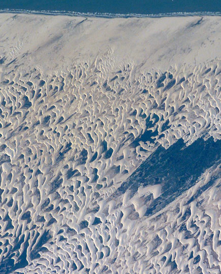
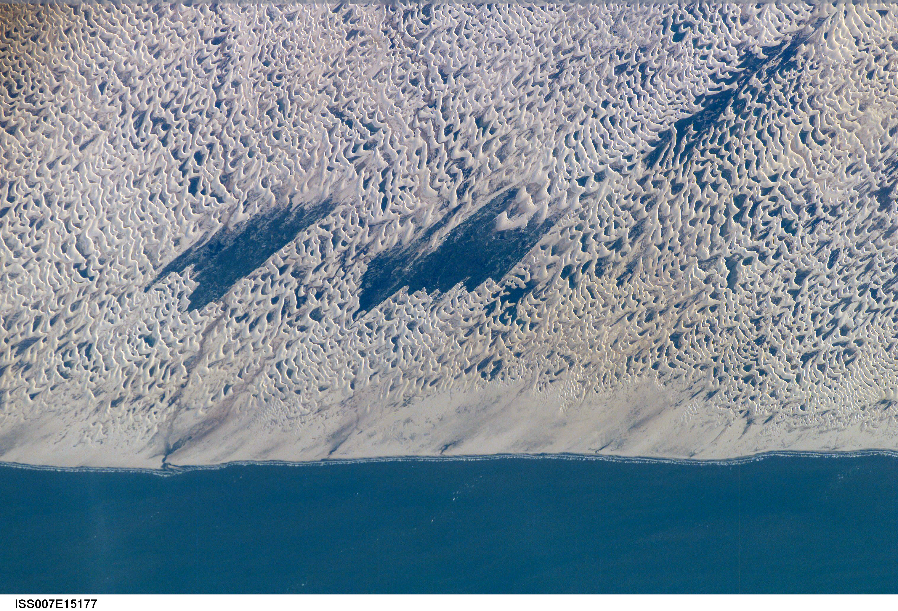
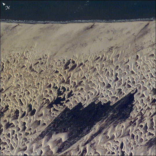
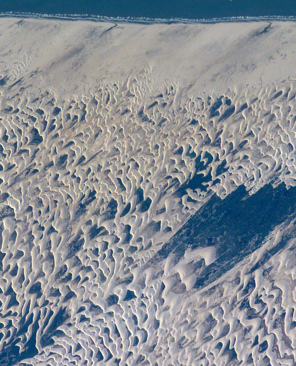
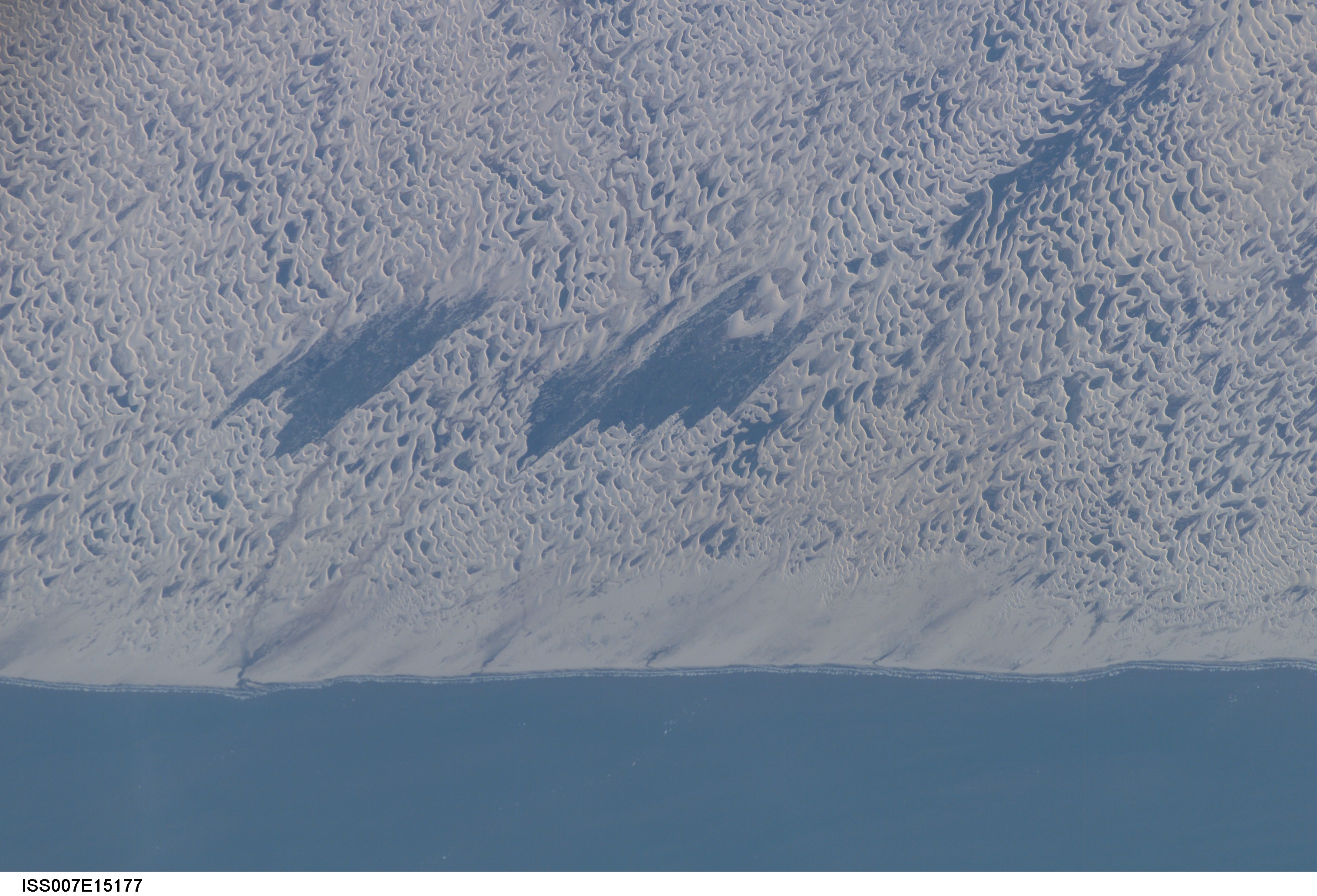
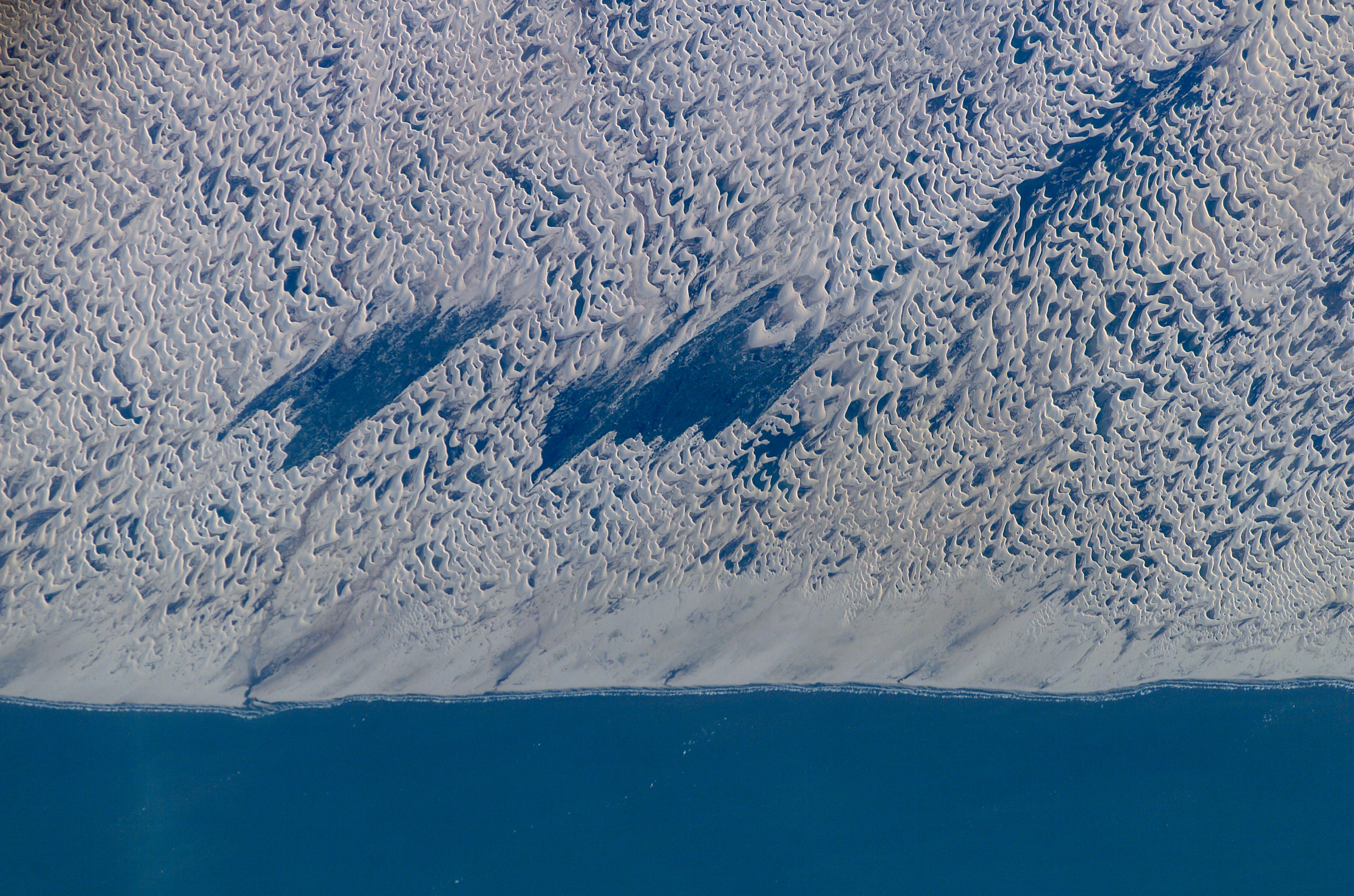
Image Caption: The area shown here (10 km across) is a small part of the dune field which is now protected as the Lencois Maranhenses National Park, on Brazil's north coast, about 700 km east of the Amazon River mouth. Persistent winds blow off the equatorial Atlantic Ocean onto Brazil from the east, driving white sand inland from the 100 km stretch of coast (upper margin of the image), to form a large field of dunes. The strongly regular pattern of these dunes is a common characteristic of dune fields. The basic shape of each sand mass, repeated throughout the view, is a crescent-shaped dune. In an area with a rich supply of sand such as coastal Brazil, individual crescents coalesce to form entire chains many miles long. The wind strength and supply of sand are sufficient to keep the dunes active, and thus free of vegetation, despite 1500 mm (60 inches) of rainfall annually. The dark areas between the white dunes are fresh water ponds that draw fisherman to this newly established park.
The characteristic regularity of the dune landscape can be detected downwind (west) for more than 100 km, beyond the present dune field. Now covered by dense forest, the greater extent of this dune field indicates that climates have been substantially drier at the Equator in the recent geological past.
The characteristic regularity of the dune landscape can be detected downwind (west) for more than 100 km, beyond the present dune field. Now covered by dense forest, the greater extent of this dune field indicates that climates have been substantially drier at the Equator in the recent geological past.
