ISS007-E-14745

| NASA Photo ID | ISS007-E-14745 |
| Focal Length | 180mm |
| Date taken | 2003.09.13 |
| Time taken | 11:18:44 GMT |
Resolutions offered for this image:
540 x 354 pixels 998 x 655 pixels 540 x 339 pixels 1000 x 659 pixels 540 x 339 pixels 540 x 356 pixels 3032 x 1998 pixels 540 x 356 pixels 3032 x 2064 pixels 6144 x 4068 pixels 639 x 435 pixels
540 x 354 pixels 998 x 655 pixels 540 x 339 pixels 1000 x 659 pixels 540 x 339 pixels 540 x 356 pixels 3032 x 1998 pixels 540 x 356 pixels 3032 x 2064 pixels 6144 x 4068 pixels 639 x 435 pixels


Cloud masks available for this image:
Spacecraft nadir point: 17.7° N, 60.7° W
Photo center point: 22.5° N, 62.0° W
Photo center point by machine learning:
Photo center point: 22.5° N, 62.0° W
Photo center point by machine learning:
Nadir to Photo Center: North
Spacecraft Altitude: 204 nautical miles (378km)
Country or Geographic Name: | ATLANTIC OCEAN |
Features: | HURRICANE ISABEL, EYE DETAIL |
| Features Found Using Machine Learning: | |
Cloud Cover Percentage: | 100 (76-100)% |
Sun Elevation Angle: | 20° |
Sun Azimuth: | 92° |
Camera: | Kodak DCS760c Electronic Still Camera |
Focal Length: | 180mm |
Camera Tilt: | High Oblique |
Format: | 3060E: 3060 x 2036 pixel CCD, RGBG array |
Film Exposure: | |
| Additional Information | |
| Width | Height | Annotated | Cropped | Purpose | Links |
|---|---|---|---|---|---|
| 540 pixels | 354 pixels | Photographic Highlights | Download Image | ||
| 998 pixels | 655 pixels | Photographic Highlights | Download Image | ||
| 540 pixels | 339 pixels | No | No | Earth From Space collection | Download Image |
| 1000 pixels | 659 pixels | No | Yes | NASA's Earth Observatory web site | Download Image |
| 540 pixels | 339 pixels | No | Yes | NASA's Earth Observatory web site | Download Image |
| 540 pixels | 356 pixels | Yes | NASA's Earth Observatory web site | Download Image | |
| 3032 pixels | 1998 pixels | No | No | Download Image | |
| 540 pixels | 356 pixels | Scientist Request | Download Image | ||
| 3032 pixels | 2064 pixels | No | No | Download Image | |
| 6144 pixels | 4068 pixels | No | No | Presentation | Download Image |
| 639 pixels | 435 pixels | No | No | Download Image |
Download Packaged File
Download a Google Earth KML for this Image
View photo footprint information
Download a GeoTIFF for this photo
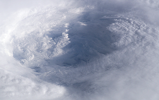
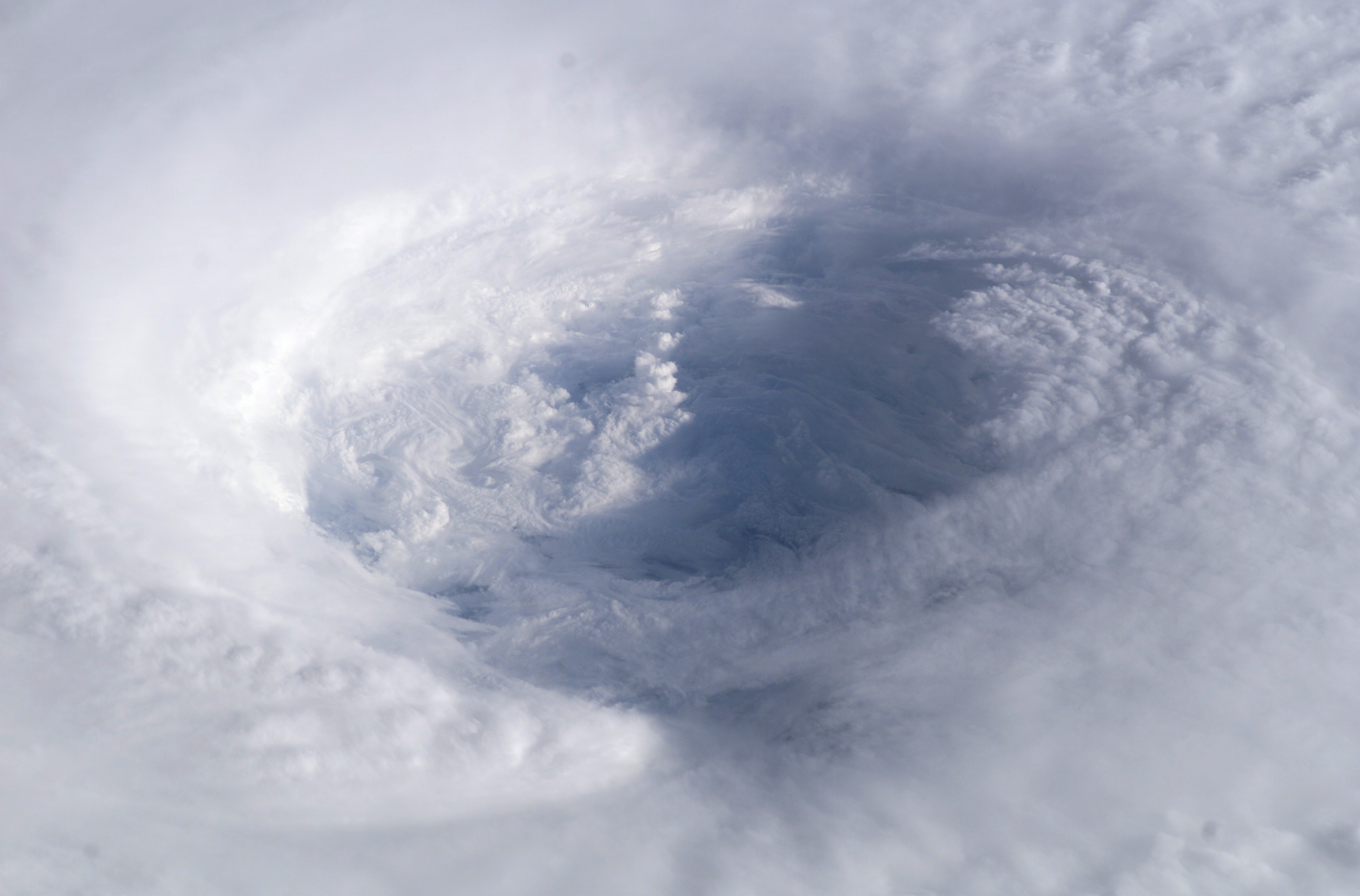
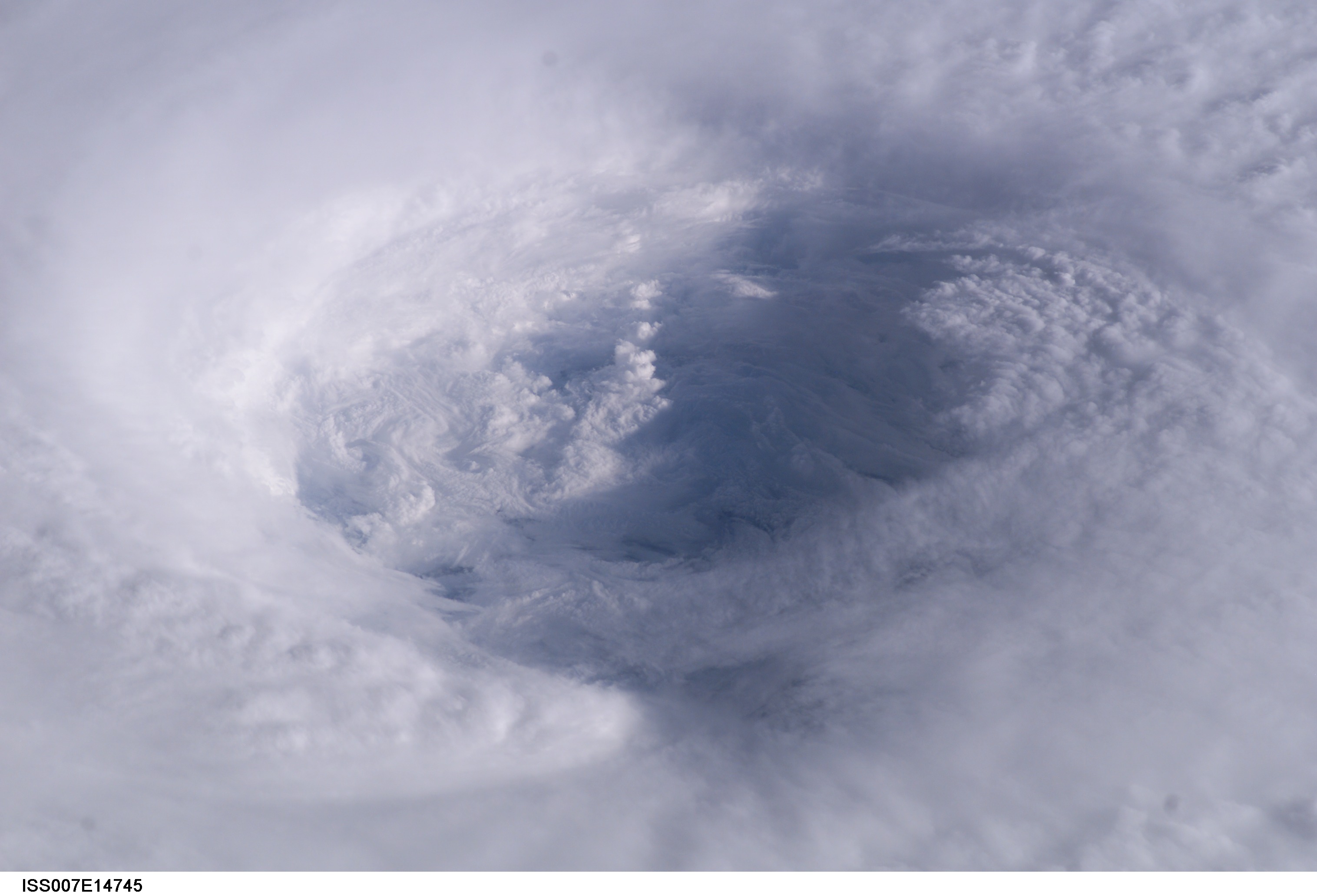
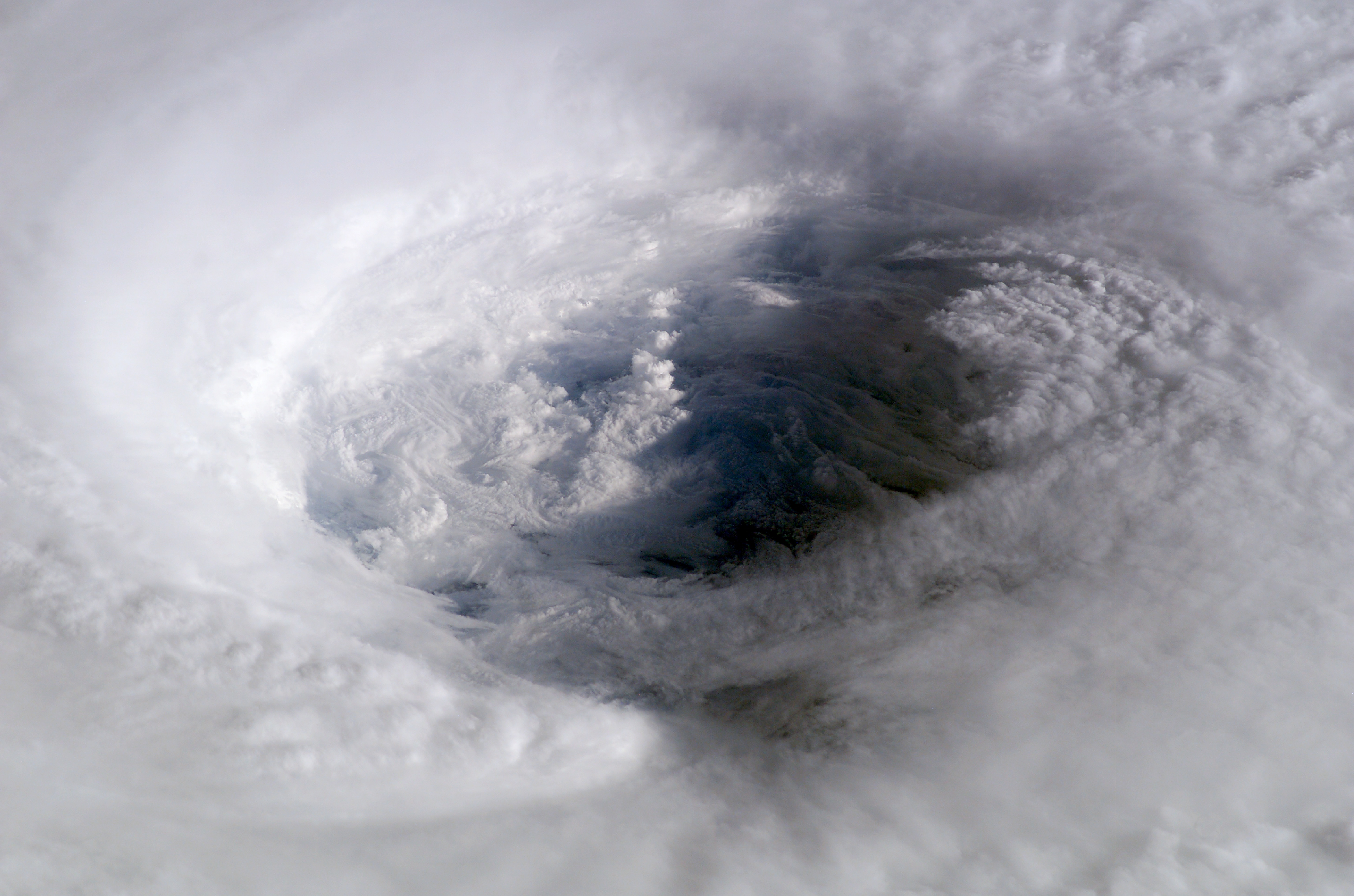
Image Caption: Astronaut Ed Lu snapped this photo of the eye of Hurricane Isabel from the International Space Station on September 13, 2003 at 11:18 UTC. At the time, Isabel was located about 450 miles northeast of Puerto Rico. It had dropped to a Category 4 hurricane on the Saffir-Simpson Hurricane Scale, packing winds of 150 miles per hour with gusts up to 184 miles per hour.
After originating in the eastern Atlantic west of the Cape Verde Islands, Isabel became the second major hurricane of the 2003 Atlantic season when it was declared a Category 3 storm by the National Hurricane Center on September 8. Over the next four days, Isabel strengthened into an extremely powerful Category 5 hurricane with winds estimated at 160 mph before weakening as it approached the eastern seaboard of the US.
Why Unique: This photo shows the structure of Isabel's eyewall. No other sensor images the eyewalls of hurricane with such detail. Previous work using images from the Shuttle of the eyewall of Hurricane Amleia allowed three dimensional studies of the eyewall structure.
These images were used by the National Hurricane Center, NOAA, the Weather Channel and many other media organizations covering the news story.
