ISS007-E-13281
| NASA Photo ID | ISS007-E-13281 |
| Focal Length | 50mm |
| Date taken | 2003.08.20 |
| Time taken | 18:51:20 GMT |
Resolutions offered for this image:
540 x 357 pixels 997 x 659 pixels 3032 x 2004 pixels 540 x 353 pixels 1000 x 661 pixels 3032 x 2064 pixels 6144 x 4068 pixels 639 x 435 pixels
540 x 357 pixels 997 x 659 pixels 3032 x 2004 pixels 540 x 353 pixels 1000 x 661 pixels 3032 x 2064 pixels 6144 x 4068 pixels 639 x 435 pixels


Cloud masks available for this image:
Spacecraft nadir point: 51.7° N, 110.2° W
Photo center point: 49.0° N, 117.5° W
Photo center point by machine learning:
Photo center point: 49.0° N, 117.5° W
Photo center point by machine learning:
Nadir to Photo Center: West
Spacecraft Altitude: 202 nautical miles (374km)
Country or Geographic Name: | USA-WASHINGTON |
Features: | FOREST FIRE SMOKE, ROCKY MTS. |
| Features Found Using Machine Learning: | |
Cloud Cover Percentage: | 50 (26-50)% |
Sun Elevation Angle: | 50° |
Sun Azimuth: | 167° |
Camera: | Kodak DCS760c Electronic Still Camera |
Focal Length: | 50mm |
Camera Tilt: | High Oblique |
Format: | 3060E: 3060 x 2036 pixel CCD, RGBG array |
Film Exposure: | |
| Additional Information | |
| Width | Height | Annotated | Cropped | Purpose | Links |
|---|---|---|---|---|---|
| 540 pixels | 357 pixels | Photographic Highlights | Download Image | ||
| 997 pixels | 659 pixels | Photographic Highlights | Download Image | ||
| 3032 pixels | 2004 pixels | Earth From Space collection | Download Image | ||
| 540 pixels | 353 pixels | Yes | Yes | Earth From Space collection | Download Image |
| 1000 pixels | 661 pixels | No | No | NASA's Earth Observatory web site | Download Image |
| 3032 pixels | 2064 pixels | No | No | Download Image | |
| 6144 pixels | 4068 pixels | No | No | Presentation | Download Image |
| 639 pixels | 435 pixels | No | No | Download Image |
Download Packaged File
Download a Google Earth KML for this Image
View photo footprint information
Download a GeoTIFF for this photo
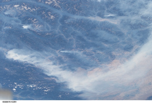
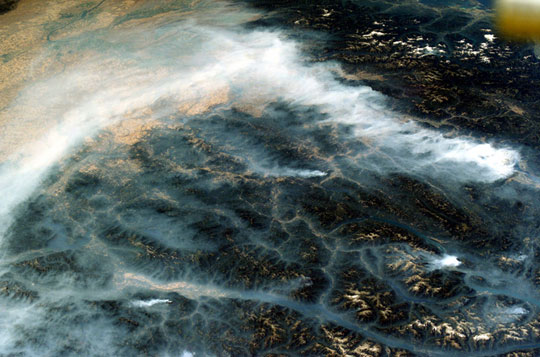
Image Caption: Fires in British Columbia: The 2003 fire season was another very active one for western North America, especially in the Canadian province of British Columbia where some 620,000 acres of forest were consumed in almost 2,500 fires. Here the Rocky Mountains have both lofty, snow-capped peaks and long, narrow valleys that create special conditions and problems with air quality from these smoky fires.
This image taken by the crew of the International Space Station on August 20, 2003, illustrates how smoke has become trapped in valleys. Normally air temperature decreases with altitude; in other words, the higher up you are, the colder it is. Warmer, more buoyant air near the surface of the Earth usually rises into the atmosphere, carrying away air pollutants such as smoke.
However, sometimes the "higher equals colder" relationship breaks down, for example, here in the northern Rockies, where light winds and cold air drainage from the higher elevations have created "temperature inversions," making the air in the valley colder and denser than the air at the mountain peaks. The cold dense air does not rise, but intsead stays trapped--along with the smoke--in the valleys. Note how the snowy peaks of the mountains are relatively smoke-free while the long, north-south valleys of Kootenay Lake and Columbia River are filled with trapped aerosols from the plumes of the large fires situated to the southwest. Meanwhile shifting winds have now swept the bulk of the plumes southeastward over the Columbia River Basin of Washington.
