ISS006-E-45499
| NASA Photo ID | ISS006-E-45499 |
| Focal Length | 800mm |
| Date taken | 2003.04.09 |
| Time taken | 08:59:40 GMT |
Resolutions offered for this image:
540 x 362 pixels 540 x 915 pixels 3032 x 2064 pixels 639 x 435 pixels
540 x 362 pixels 540 x 915 pixels 3032 x 2064 pixels 639 x 435 pixels
Cloud masks available for this image:
Spacecraft nadir point: 1.8° N, 35.1° E
Photo center point: 3.0° S, 37.5° E
Photo center point by machine learning: 1.30° N, 36.12° E
Photo center point: 3.0° S, 37.5° E
Photo center point by machine learning: 1.30° N, 36.12° E
Nadir to Photo Center: South
Spacecraft Altitude: 210 nautical miles (389km)

Country or Geographic Name: | TANZANIA |
Features: | MOUNT KILIMANJARO |
| Features Found Using Machine Learning: | |
Cloud Cover Percentage: | 25 (11-25)% |
Sun Elevation Angle: | 78° |
Sun Azimuth: | 61° |
Camera: | Kodak DCS760c Electronic Still Camera |
Focal Length: | 800mm |
Camera Tilt: | High Oblique |
Format: | 3060E: 3060 x 2036 pixel CCD, RGBG array |
Film Exposure: | |
| Additional Information | |
| Width | Height | Annotated | Cropped | Purpose | Links |
|---|---|---|---|---|---|
| 540 pixels | 362 pixels | Yes | Yes | NASA's Earth Observatory web site | Download Image |
| 540 pixels | 915 pixels | Yes | Yes | NASA's Earth Observatory web site | Download Image |
| 3032 pixels | 2064 pixels | No | No | Download Image | |
| 639 pixels | 435 pixels | No | No | Download Image |
Download Packaged File
Download a Google Earth KML for this Image
View photo footprint information
Download a GeoTIFF for this photo
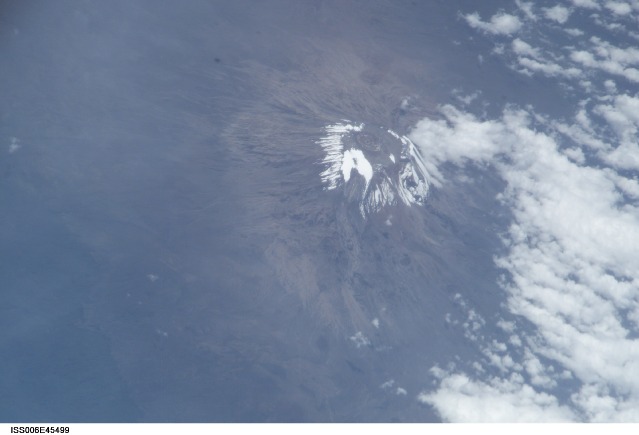
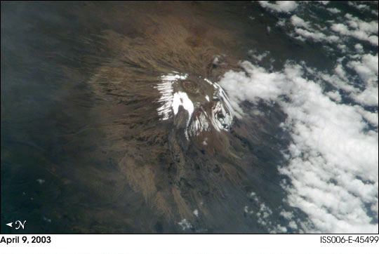
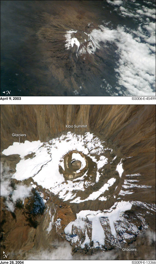
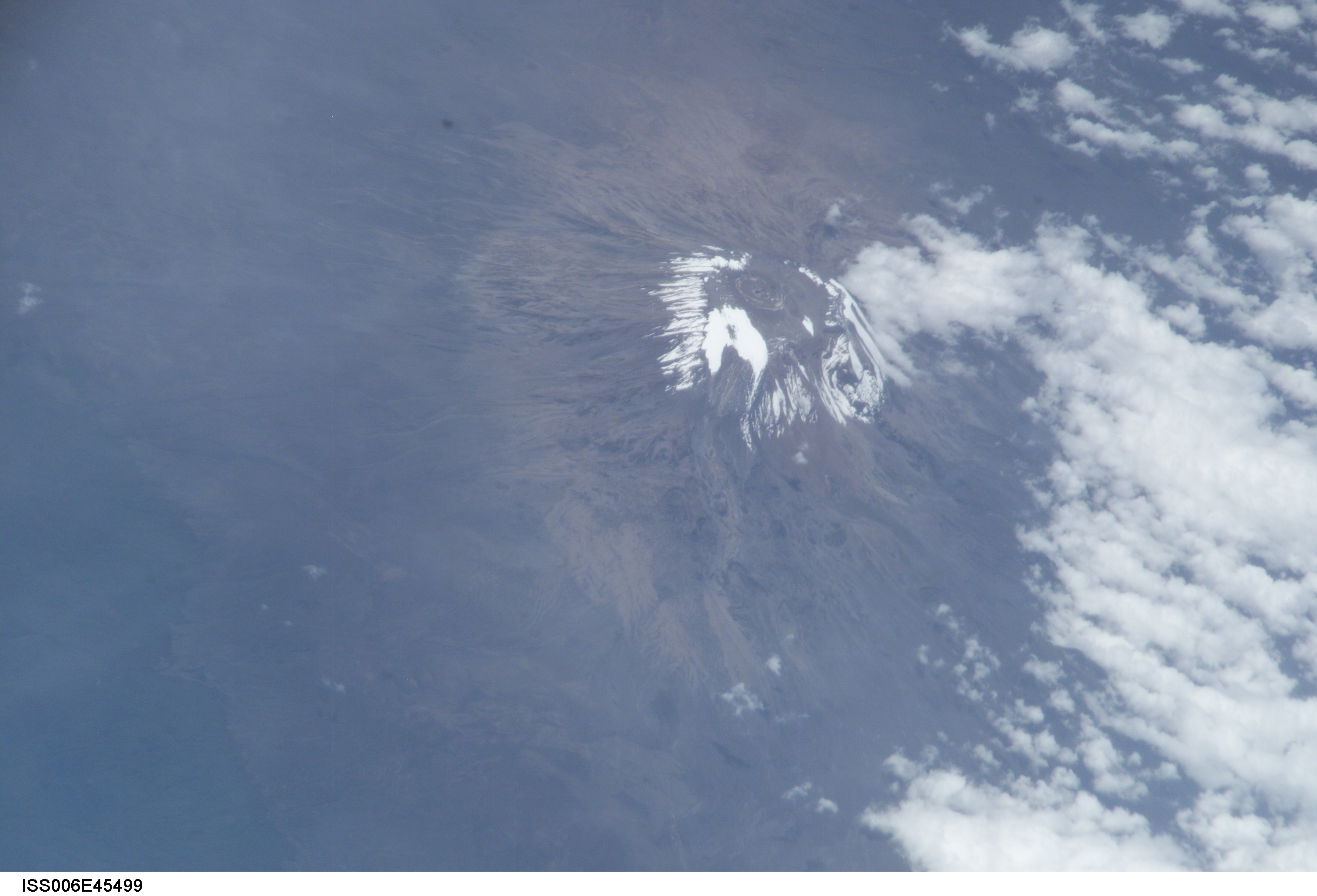
Image Caption: Mount Kilimanjaro is a dormant stratovolcano and the highest mountain in Africa. Kibo Summit (5,893 m) at the top of Kilimanjaro is one of the few peaks in Africa to retain glaciers. This image is a high oblique photograph taken from the International Space Station in early April 2003. That photograph provides a 3-dimensional perspective on the positions of the glaciers on the upper northwestern and southern flanks of the mountain. A comparison photograph, ISS009-E-13366, taken from the International Space Station in late June 2004, shows large glacier fields (blue-white, with defined edges) on the northwestern and southern slopes of the peak. In this scene, a light layer of snow brightens the dark brown terrain around the glaciers.
Scientists use ice cores, an automated weather station, computer modeling, and images like these as tools to learn about the past and present activity of Kilimanjaro's receding glaciers. One atmospheric scientist at the University of Wisconsin-Madison found clues that link reduced cloud cover to post-1880 decreased water levels in East African lakes. Lake evaporation indicates a decrease in both precipitation and cloudiness around Kilimanjaro. These two images illustrate the changes over time in snow cover at the summit as well as the current extent of the glaciers themselves. Light brown outwash channels from the northwestern flank icefield are particularly evident in the oblique photograph (top). While clear conditions over Kilimanjaro allow for the collection of spectacular images like these, the lack of cloud cover may be one cause for the glaciers' retreat. The increased sunlight facilitates faster evaporation and less precipitation--thus, the land surface absorbs more incoming sunlight and, as it warms, the ice and snow melts at an accelerated pace.
Most scientists agree that the glaciers of Mt. Kilimanjaro will be gone by the year 2020, but there is less agreement as to why they are now receding. Climatologists are now studying current weather trends, environmental changes from the late 1800s, and historical records of the mountain climate compared with longer-term climate records at lower elevations. A correct interpretation of the ice core data may help provide an explanation for this glacial recession. The loss of Kilimanjaro's permanent ice fields will have both climatological and hydrological implications for local populations who depend on access to melt water from the ice fields as a source of fresh water during dry seasons and monsoon failures.
