ISS006-E-40113
| NASA Photo ID | ISS006-E-40113 |
| Focal Length | 28mm |
| Date taken | 2003.03.19 |
| Time taken | 05:04:13 GMT |

Cloud masks available for this image:
Spacecraft nadir point: 45.5° S, 166.5° E
Photo center point: 44.0° S, 170.0° E
Photo center point by machine learning:
Photo center point: 44.0° S, 170.0° E
Photo center point by machine learning:
Nadir to Photo Center: East
Spacecraft Altitude: 211 nautical miles (391km)
Country or Geographic Name: | NEW ZEALAND-SI |
Features: | PAN-OBLIQUE VIEW |
| Features Found Using Machine Learning: | |
Cloud Cover Percentage: | 10 (1-10)% |
Sun Elevation Angle: | 21° |
Sun Azimuth: | 291° |
Camera: | Kodak DCS760c Electronic Still Camera |
Focal Length: | 28mm |
Camera Tilt: | 47 degrees |
Format: | 3060E: 3060 x 2036 pixel CCD, RGBG array |
Film Exposure: | |
| Additional Information | |
| Width | Height | Annotated | Cropped | Purpose | Links |
|---|---|---|---|---|---|
| 3032 pixels | 2064 pixels | No | No | Download Image | |
| 639 pixels | 435 pixels | No | No | Download Image |
Download Packaged File
Download a Google Earth KML for this Image
View photo footprint information
Download a GeoTIFF for this photo
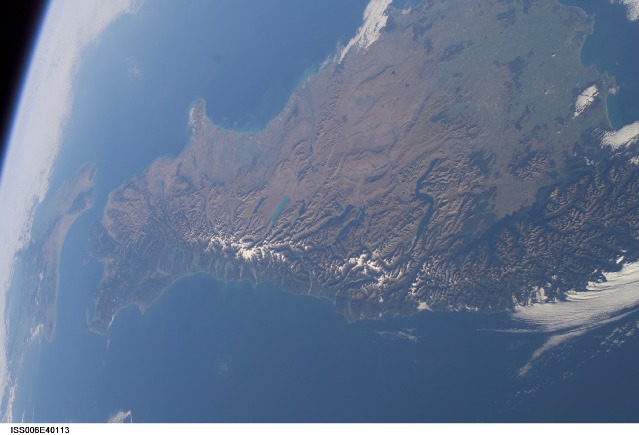
Image Caption: ISS006-E-40113 (19 March 2003) --- An oblique view of the South Island of New Zealand as photographed from the International Space Station by astronaut Donald R. Pettit, NASA ISS science officer and flight engineer for Expedition 6. Nadir point coordinates of the picture are 45.5 degrees south latitude and 166.5 degrees east longitude. The International Space Station was flying at an altitude of 211 nautical miles (391 kilometers) when the photo was taken.
