ISS006-E-38306
| NASA Photo ID | ISS006-E-38306 |
| Focal Length | 180mm |
| Date taken | 2003.03.14 |
| Time taken | 15:23:10 GMT |
540 x 357 pixels 1000 x 661 pixels 540 x 334 pixels 3032 x 2064 pixels 639 x 435 pixels
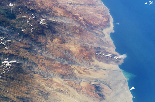

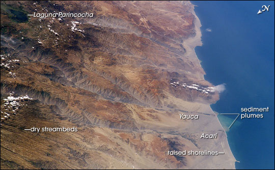

Photo center point: 15.5° S, 74.0° W
Photo center point by machine learning:
Country or Geographic Name: | PERU |
Features: | COASTLINE, ANDES RANGE |
| Features Found Using Machine Learning: | |
Cloud Cover Percentage: | 10 (1-10)% |
Sun Elevation Angle: | 58° |
Sun Azimuth: | 81° |
Camera: | Kodak DCS760c Electronic Still Camera |
Focal Length: | 180mm |
Camera Tilt: | High Oblique |
Format: | 3060E: 3060 x 2036 pixel CCD, RGBG array |
Film Exposure: | |
| Additional Information | |
| Width | Height | Annotated | Cropped | Purpose | Links |
|---|---|---|---|---|---|
| 540 pixels | 357 pixels | Yes | Yes | Earth From Space collection | Download Image |
| 1000 pixels | 661 pixels | No | Yes | NASA's Earth Observatory web site | Download Image |
| 540 pixels | 334 pixels | Yes | Yes | NASA's Earth Observatory web site | Download Image |
| 3032 pixels | 2064 pixels | No | No | Download Image | |
| 639 pixels | 435 pixels | No | No | Download Image |
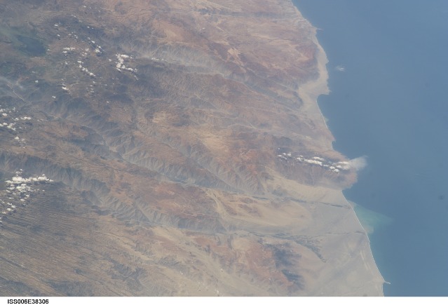
Following the last major upheaval of the Andes Mountains, rivers flowing down into the Pacific Ocean have carved dramatic canyons along Peru's southern coast. In geologic terms, the canyons are relatively young--carved over the past 8 million years. This oblique (off-vertical) image from March 14, 2003, provides a southward look down Peru's rugged, arid coastline between 15.5 and 17 degrees South latitude. The canyons run from left to right and appear grayer than the surrounding reddish-brown terrain.
The canyons found here are some of the deepest and steepest on Earth--lake Laguna Parincocha (top left corner) lies on the Andean plateau about 3,250 meters (10,700 feet) above sea level, about 80 kilometers (50 miles) from the coast. At lower left, a dense pattern of parallel grooves has been carved into a sheet of volcanic rock by now-dry streams. The volcanic rock is a kind called ignimbrite, which is the result of an eruption of hot gases and small rock fragments that flow from the volcano like a fluid (a pyroclastic flow). In an ignimbrite, the rock fragments are mostly pumice, a lightweight volcanic glass full of cavities.
The Yauca and Acari rivers feed small, tan-colored sediment plumes into the sea (lower right). Dark green agricultural fields cluster along the lower courses of the rivers. Strong southerly winds have generated sand dunes and dark wind streaks along the coast, whose alignments re-curve inland into the lower river valleys (lower right). The coast and canyons are commonly hazy due to oceanic air and blowing dust. Yellow lines parallel with the coast and near the small peninsula are raised shorelines probably caused by tectonic uplift of the coastline.
