ISS006-E-33901
| NASA Photo ID | ISS006-E-33901 |
| Focal Length | 28mm |
| Date taken | 2003.02.26 |
| Time taken | 09:47:34 GMT |
Resolutions offered for this image:
1024 x 768 pixels 540 x 405 pixels 540 x 365 pixels 1000 x 676 pixels 3032 x 2064 pixels 639 x 435 pixels
1024 x 768 pixels 540 x 405 pixels 540 x 365 pixels 1000 x 676 pixels 3032 x 2064 pixels 639 x 435 pixels


Cloud masks available for this image:
Spacecraft nadir point: 51.5° N, 12.1° E
Photo center point: 56.0° N, 9.0° E
Photo center point by machine learning:
Photo center point: 56.0° N, 9.0° E
Photo center point by machine learning:
Nadir to Photo Center: Northwest
Spacecraft Altitude: 211 nautical miles (391km)
Country or Geographic Name: | DENMARK |
Features: | PAN-JUTLAND PENINSULA, SCANDINAVIA |
| Features Found Using Machine Learning: | PAN- |
Cloud Cover Percentage: | 25 (11-25)% |
Sun Elevation Angle: | 26° |
Sun Azimuth: | 153° |
Camera: | Kodak DCS760c Electronic Still Camera |
Focal Length: | 28mm |
Camera Tilt: | High Oblique |
Format: | 3060E: 3060 x 2036 pixel CCD, RGBG array |
Film Exposure: | |
| Additional Information | |
| Width | Height | Annotated | Cropped | Purpose | Links |
|---|---|---|---|---|---|
| 1024 pixels | 768 pixels | Photographic Highlights | Download Image | ||
| 540 pixels | 405 pixels | Photographic Highlights | Download Image | ||
| 540 pixels | 365 pixels | Yes | Yes | Earth From Space collection | Download Image |
| 1000 pixels | 676 pixels | No | Yes | NASA's Earth Observatory web site | Download Image |
| 3032 pixels | 2064 pixels | No | No | Download Image | |
| 639 pixels | 435 pixels | No | No | Download Image |
Download Packaged File
Download a Google Earth KML for this Image
View photo footprint information
Download a GeoTIFF for this photo
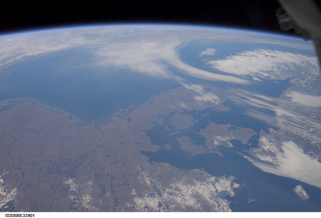
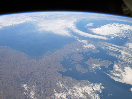
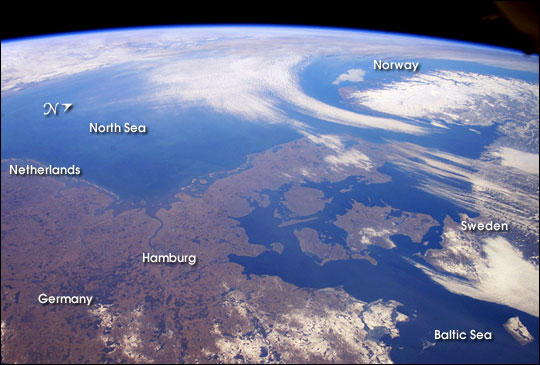
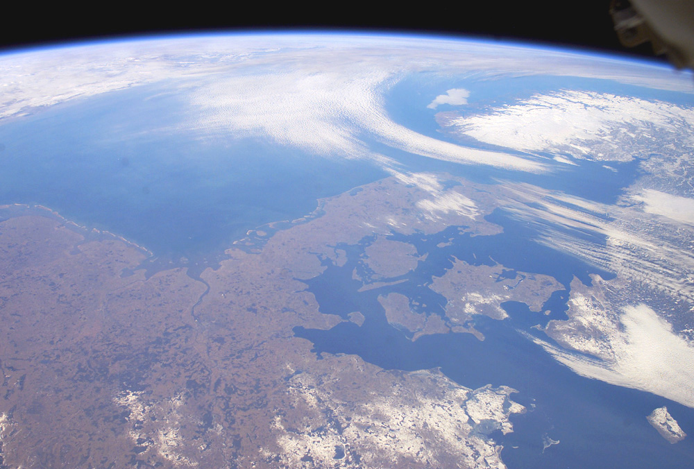
Image Caption: The Kingdom of Denmark, with an area of 16,639 square miles, consists of the Jutland Peninsula and roughly 500 islands. It is also a part of the generally fertile and mostly agricultural region known as the North European Plain. This entire region is generally flat to slightly rolling and is overlain with deposits of Pleistocene glaciers. (The Pleistocene lasted from 1.8 million to 11,000 years ago, during which time several ice ages occured.)
Taking advantage of remarkably fair weather over north central Europe for this time of year, the crew of the International Space Station took this panoramic view that extends from the North Sea coast of the Netherlands on the left to the Baltic Sea shores of Sweden on the right. The late-winter landscape has little snow cover except over northeastern Germany, Sweden, and the rugged mountains of Norway. Such images, composed by astronauts, provide unique, synoptic perspectives of the Earth's geography and natural processes.
Taking advantage of remarkably fair weather over north central Europe for this time of year, the crew of the International Space Station took this panoramic view that extends from the North Sea coast of the Netherlands on the left to the Baltic Sea shores of Sweden on the right. The late-winter landscape has little snow cover except over northeastern Germany, Sweden, and the rugged mountains of Norway. Such images, composed by astronauts, provide unique, synoptic perspectives of the Earth's geography and natural processes.
