ISS006-E-30534
| NASA Photo ID | ISS006-E-30534 |
| Focal Length | 180mm |
| Date taken | 2003.02.19 |
| Time taken | 09:58:01 GMT |

Cloud masks available for this image:
Spacecraft nadir point: 48.2° N, 14.9° E
Photo center point: 47.0° N, 12.5° E
Photo center point by machine learning:
Photo center point: 47.0° N, 12.5° E
Photo center point by machine learning:
Nadir to Photo Center: Southwest
Spacecraft Altitude: 212 nautical miles (393km)
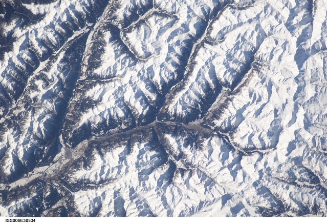
Country or Geographic Name: | AUSTRIA |
Features: | ALPS MOUNTAIN RANGE |
| Features Found Using Machine Learning: | |
Cloud Cover Percentage: | 10 (1-10)% |
Sun Elevation Angle: | 28° |
Sun Azimuth: | 159° |
Camera: | Kodak DCS760c Electronic Still Camera |
Focal Length: | 180mm |
Camera Tilt: | 37 degrees |
Format: | 3060E: 3060 x 2036 pixel CCD, RGBG array |
Film Exposure: | |
| Additional Information | |
| Width | Height | Annotated | Cropped | Purpose | Links |
|---|---|---|---|---|---|
| 3032 pixels | 2064 pixels | No | No | Download Image | |
| 639 pixels | 435 pixels | No | No | Download Image |
Download Packaged File
Download a Google Earth KML for this Image
View photo footprint information
Download a GeoTIFF for this photo
Image Caption: This image shows the valley of the upper Drau (Drava) around Lienz and the western part of the "Hohe Tauern" chain, named "Venediger Tauern" with the "Grossvenediger", Austria's 2nd highest mountain (3674 m) clearly visible. (submitted by Paul De Krock)
