ISS006-E-29393
| NASA Photo ID | ISS006-E-29393 |
| Focal Length | 28mm |
| Date taken | 2003.02.21 |
| Time taken | 20:38:46 GMT |
Resolutions offered for this image:
353 x 540 pixels 502 x 768 pixels 540 x 405 pixels 1000 x 1518 pixels 3032 x 2064 pixels 639 x 435 pixels
353 x 540 pixels 502 x 768 pixels 540 x 405 pixels 1000 x 1518 pixels 3032 x 2064 pixels 639 x 435 pixels


Cloud masks available for this image:
Spacecraft nadir point: 43.5° N, 89.8° W
Photo center point: 42.5° N, 86.0° W
Photo center point by machine learning:
Photo center point: 42.5° N, 86.0° W
Photo center point by machine learning:
Nadir to Photo Center: East
Spacecraft Altitude: 210 nautical miles (389km)
Country or Geographic Name: | USA-MICHIGAN |
Features: | LAKE MICHIGAN, ICE, SNOW |
| Features Found Using Machine Learning: | |
Cloud Cover Percentage: | 10 (1-10)% |
Sun Elevation Angle: | 27° |
Sun Azimuth: | 221° |
Camera: | Kodak DCS760c Electronic Still Camera |
Focal Length: | 28mm |
Camera Tilt: | 48 degrees |
Format: | 3060E: 3060 x 2036 pixel CCD, RGBG array |
Film Exposure: | |
| Additional Information | |
| Width | Height | Annotated | Cropped | Purpose | Links |
|---|---|---|---|---|---|
| 353 pixels | 540 pixels | Photographic Highlights | Download Image | ||
| 502 pixels | 768 pixels | Photographic Highlights | Download Image | ||
| 540 pixels | 405 pixels | Yes | Yes | Earth From Space collection | Download Image |
| 1000 pixels | 1518 pixels | No | No | NASA's Earth Observatory web site | Download Image |
| 3032 pixels | 2064 pixels | No | No | Download Image | |
| 639 pixels | 435 pixels | No | No | Download Image |
Download Packaged File
Download a Google Earth KML for this Image
View photo footprint information
Download a GeoTIFF for this photo
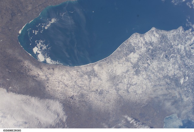
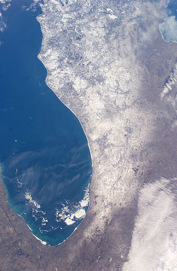
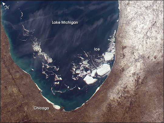
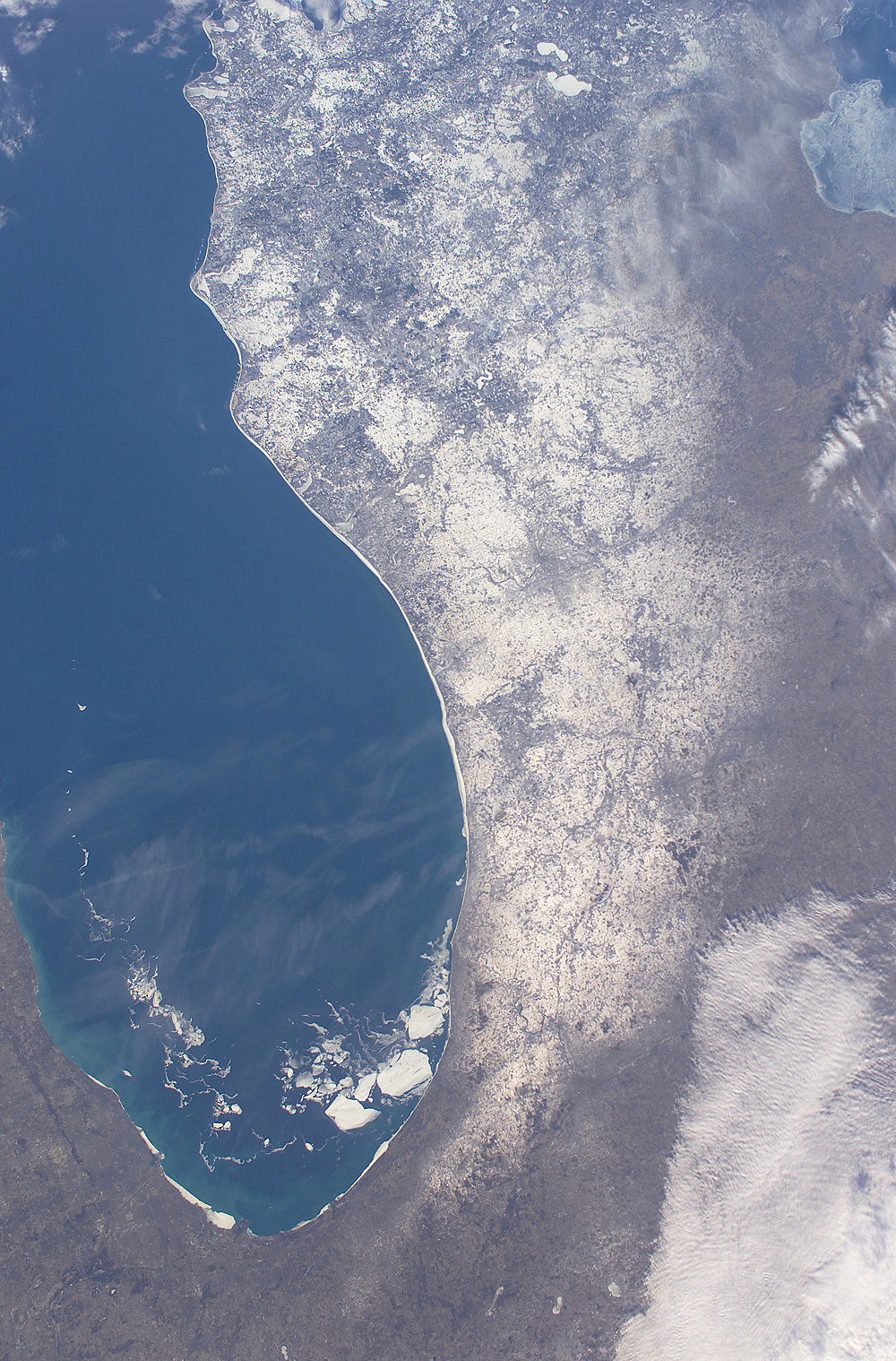
Image Caption: A colder than normal North American winter saw the entire surface areas of Lakes Superior, Huron, and Erie frozen over for the first time in years. The cold has delayed the opening of the St. Lawrence Seaway and will likely delay the start of the growing season near the Great Lake shorelines. Although the open surface waters of Lake Michigan did not freeze this season, the southern portion experienced a higher than normal amount of ice. Winds and currents drove broken pieces of ice from the north to the south.
This image taken from the International Space Station shows a number of large pieces of ice collected along and just off the shoreline southwest of Benton Harbor, Michigan. Smaller pieces trail northward offshore from Chicago, Illinois. Note the ice accumulation along the entire eastern shoreline of Lake Michigan as well as the wind-drive lake-effect snow cover over the western half of the lower Michigan Peninsula.
This image taken from the International Space Station shows a number of large pieces of ice collected along and just off the shoreline southwest of Benton Harbor, Michigan. Smaller pieces trail northward offshore from Chicago, Illinois. Note the ice accumulation along the entire eastern shoreline of Lake Michigan as well as the wind-drive lake-effect snow cover over the western half of the lower Michigan Peninsula.
