ISS006-E-24783
| NASA Photo ID | ISS006-E-24783 |
| Focal Length | 180mm |
| Date taken | 2003.02.06 |
| Time taken | 21:55:02 GMT |
Resolutions offered for this image:
540 x 540 pixels 1000 x 685 pixels 3032 x 2064 pixels 639 x 435 pixels
540 x 540 pixels 1000 x 685 pixels 3032 x 2064 pixels 639 x 435 pixels

Cloud masks available for this image:
Spacecraft nadir point: 37.4° N, 113.9° W
Photo center point: 36.5° N, 118.0° W
Photo center point by machine learning:
Photo center point: 36.5° N, 118.0° W
Photo center point by machine learning:
Nadir to Photo Center: West
Spacecraft Altitude: 205 nautical miles (380km)
Country or Geographic Name: | USA-CALIFORNIA |
Features: | OWENS LAKE, SIERRA NEVADA, LONE PINE |
| Features Found Using Machine Learning: | SALT LAKE CITY |
Cloud Cover Percentage: | 10 (1-10)% |
Sun Elevation Angle: | 30° |
Sun Azimuth: | 215° |
Camera: | Kodak DCS760c Electronic Still Camera |
Focal Length: | 180mm |
Camera Tilt: | 51 degrees |
Format: | 3060E: 3060 x 2036 pixel CCD, RGBG array |
Film Exposure: | |
| Additional Information | |
| Width | Height | Annotated | Cropped | Purpose | Links |
|---|---|---|---|---|---|
| 540 pixels | 540 pixels | Yes | Yes | Earth From Space collection | Download Image |
| 1000 pixels | 685 pixels | No | Yes | NASA's Earth Observatory web site | Download Image |
| 3032 pixels | 2064 pixels | No | No | Download Image | |
| 639 pixels | 435 pixels | No | No | Download Image |
Download Packaged File
Download a Google Earth KML for this Image
View photo footprint information
Download a GeoTIFF for this photo
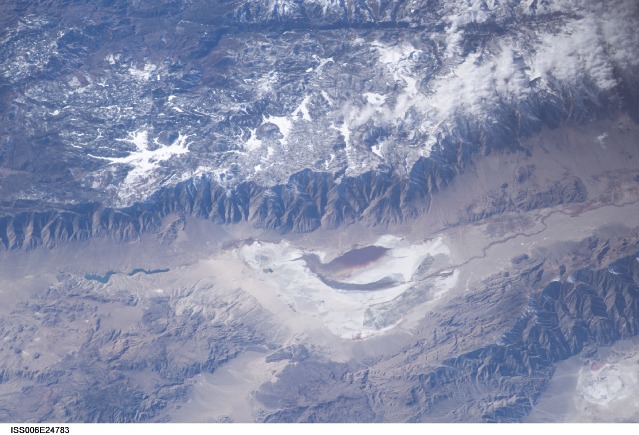
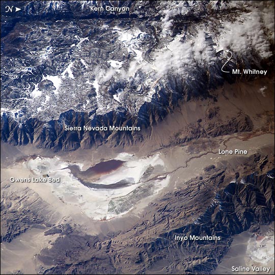
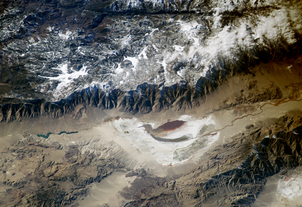
Image Caption: Astronauts aboard the International Space Station looked obliquely down at the steep eastern flank of California's Sierra Nevada. Even from space the topography is impressive--the range drops nearly 11,000 feet from Mt. Whitney (under cloud, arrow), the highest mountain in the lower 48 states (14,494 ft), to the floor of Owens Valley (the elevation of the town of Lone Pine is 3,760 ft). The Sierra Nevada landscape is well known for deep, glacially scoured valleys, like Kern Canyon west of Mt. Whitney.
The California landscape changes east of the Sierra, marked by alternating steep desert mountain ranges and valleys. Many of the valleys contain dry lakebeds, remnants of deep lakes that filled the valleys 11,000 years ago, at the end of the last ice age. Owens Lake was a salty lake until 1913, when the Owens River was diverted into the Los Angeles Aqueduct, quickly draining the lake. Today, Owens Lake is a dried salt flat that contains some pooled water following rains. Solar evaporation ponds lie along the northern edge. The bright red color in the wet parts of the lakebed is from the red color of salt-loving bacteria (halobacteria).
The California landscape changes east of the Sierra, marked by alternating steep desert mountain ranges and valleys. Many of the valleys contain dry lakebeds, remnants of deep lakes that filled the valleys 11,000 years ago, at the end of the last ice age. Owens Lake was a salty lake until 1913, when the Owens River was diverted into the Los Angeles Aqueduct, quickly draining the lake. Today, Owens Lake is a dried salt flat that contains some pooled water following rains. Solar evaporation ponds lie along the northern edge. The bright red color in the wet parts of the lakebed is from the red color of salt-loving bacteria (halobacteria).
