ISS005-E-9691
| NASA Photo ID | ISS005-E-9691 |
| Focal Length | 800mm |
| Date taken | 2002.08.13 |
| Time taken | 11:07:38 GMT |
Resolutions offered for this image:
540 x 787 pixels 1000 x 1242 pixels 1024 x 768 pixels 540 x 405 pixels 3032 x 2064 pixels 639 x 435 pixels
540 x 787 pixels 1000 x 1242 pixels 1024 x 768 pixels 540 x 405 pixels 3032 x 2064 pixels 639 x 435 pixels


Cloud masks available for this image:
Spacecraft nadir point: 44.0° N, 46.2° E
Photo center point: 42.5° N, 44.5° E
Photo center point by machine learning:
Photo center point: 42.5° N, 44.5° E
Photo center point by machine learning:
Nadir to Photo Center: Southwest
Spacecraft Altitude: 208 nautical miles (385km)
Country or Geographic Name: | RUSSIAN FEDERATION |
Features: | MOUNT KAZBEK, GLACIERS |
| Features Found Using Machine Learning: | |
Cloud Cover Percentage: | 10 (1-10)% |
Sun Elevation Angle: | 50° |
Sun Azimuth: | 233° |
Camera: | Kodak DCS760c Electronic Still Camera |
Focal Length: | 800mm |
Camera Tilt: | 33 degrees |
Format: | 3060E: 3060 x 2036 pixel CCD, RGBG array |
Film Exposure: | |
| Additional Information | |
| Width | Height | Annotated | Cropped | Purpose | Links |
|---|---|---|---|---|---|
| 540 pixels | 787 pixels | Yes | Yes | Earth From Space collection | Download Image |
| 1000 pixels | 1242 pixels | No | NASA's Earth Observatory web site | Download Image | |
| 1024 pixels | 768 pixels | Yes | Presentation | Download Image | |
| 540 pixels | 405 pixels | Scientist Request | Download Image | ||
| 3032 pixels | 2064 pixels | No | No | Download Image | |
| 639 pixels | 435 pixels | No | No | Download Image |
Download Packaged File
Download a Google Earth KML for this Image
View photo footprint information
Download a GeoTIFF for this photo
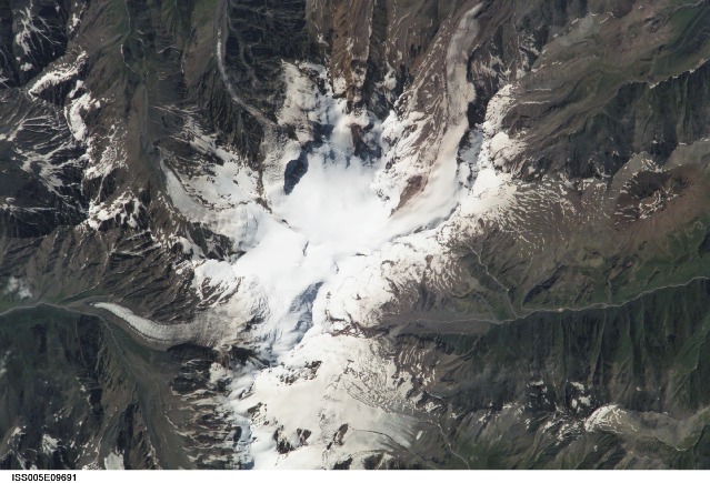
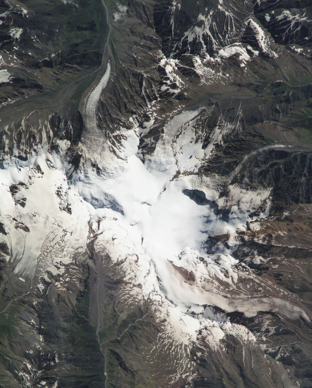
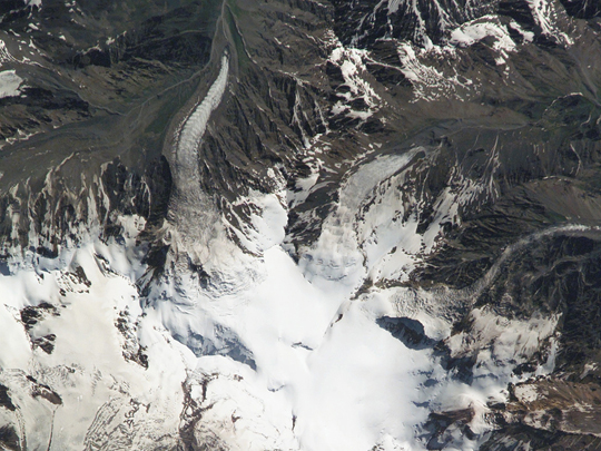
Image Caption: This photograph of Mt. Kazbek was taken from the International Space Station on August 13, 2002. The astronauts and cosmonauts took the photograph at the request of the Russian URAGAN project, which is studying changes in the world's glaciers in response to global climate change. Although scientists have predicted the possibility of large glacial collapses as the climate warms, no one predicted that tragedy would strike the mountain village of Karmadon, a little more than a month later.
On September 20 a collapse of a hanging glacier from the slope of Mt Dzhimarai-Khokh onto the Kolka glacier triggered an avalanche of ice and debris that went over the Maili Glacier terminus then slid over 15 miles. It buried small villages in the Russian Republic of North Ossetia, killing dozens of people. Where the ice stopped, the glacial debris flow dammed rivers further below. Several lakes formed and one of them flooded a village. The lakes are now threatening to burst and form debris flows.
This photograph shows the lower part of the Kolka Glacier terminus, on to which the glacier from Mt Dzhimarai-Khokh collapsed--the mountain itself is further to the west. However, the Maili Glacier and its terminus, as well as the upper part of the Genaldon River valley that was filled by the debris slide is very clear in the photo. In this very detailed view, Karmadon is much further to the North.
Exactly a hundred years ago, in 1902, the same kind of catastrophe happened in this valley, killing 32 people. In 1969 Kolka Glacier surged, but there were no casualties and the villages were not affected. The 1969 surge was studied by a special expedition, however after the glacier stabilized, research in the area stopped. It was concluded that the 1902 catastrophe was also a result of a glacier surge. The latest data on the 2002 catastrophe raise doubts in this conclusion--it is possible that the 1902 event resulted from a similar cascade of collapses.
Russian scientists Olga Tutubalina, Dmitry Petrakov, Sergei Chernomorets (Moscow State University) and Lev Dessinov (Russian Academy of Sciences) have been cooperating with the NASA Crew Earth Observations project to help interpret detailed glacier imagery captured from the International Space Station. International Space Station crewmembers are surveying glaciers around the world using their low orbit and high-magnification lenses to get high spatial resolution.
