ISS005-E-13929
| NASA Photo ID | ISS005-E-13929 |
| Focal Length | 400mm |
| Date taken | 2002.09.12 |
| Time taken | 20:50:38 GMT |
Resolutions offered for this image:
3032 x 2008 pixels 540 x 357 pixels 1000 x 662 pixels 3032 x 2064 pixels 3032 x 2008 pixels 639 x 435 pixels
3032 x 2008 pixels 540 x 357 pixels 1000 x 662 pixels 3032 x 2064 pixels 3032 x 2008 pixels 639 x 435 pixels


Cloud masks available for this image:
Spacecraft nadir point: 26.1° N, 174.2° W
Photo center point: 28.0° N, 176.0° W
Photo center point by machine learning:
Photo center point: 28.0° N, 176.0° W
Photo center point by machine learning:
Nadir to Photo Center: Northwest
Spacecraft Altitude: 211 nautical miles (391km)
Country or Geographic Name: | USA-HAWAII |
Features: | PEARL AND HERMES REEF |
| Features Found Using Machine Learning: | |
Cloud Cover Percentage: | 10 (1-10)% |
Sun Elevation Angle: | 45° |
Sun Azimuth: | 113° |
Camera: | Kodak DCS760c Electronic Still Camera |
Focal Length: | 400mm |
Camera Tilt: | 37 degrees |
Format: | 3060E: 3060 x 2036 pixel CCD, RGBG array |
Film Exposure: | |
| Additional Information | |
| Width | Height | Annotated | Cropped | Purpose | Links |
|---|---|---|---|---|---|
| 3032 pixels | 2008 pixels | No | Yes | Earth From Space collection | Download Image |
| 540 pixels | 357 pixels | Yes | Yes | Earth From Space collection | Download Image |
| 1000 pixels | 662 pixels | No | Yes | NASA's Earth Observatory web site | Download Image |
| 3032 pixels | 2064 pixels | No | No | Download Image | |
| 3032 pixels | 2008 pixels | No | No | Reef RS | Download Image |
| 639 pixels | 435 pixels | No | No | Download Image |
Download Packaged File
Download a Google Earth KML for this Image
View photo footprint information
Download a GeoTIFF for this photo
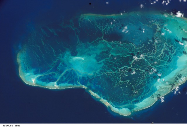
Image Caption: Measuring Water Depth from the International Space Station:
Looking out the window of the International Space Station, astronauts often take the time to admire and photograph tropical islands and coral reefs. From an altitude of 400 km and with only a digital camera as a tool, it seems impossible to make detailed measurements of the depth of underwater features. However, a new technique developed by NOAA scientists has done just that--plotted the depths of lagoon features at Pearl and Hermes Reef, northwest Hawaii, using digital astronaut photography from the International Space Station (ISS).
Measuring water depth is an important step in mapping coral reef environments. Even though digital cameras are designed to visually approximate film photographs, the information they collect is similar to the bands of different wavelengths of light collected by multispectral instruments on satellites. NOAA scientists developed an algorithm that could estimate bathymetry from the blue and green bands in IKONOS satellite data. After calibrating the astronaut photography to the signal in the IKONOS data, the same algorithm could be successfully used with the blue and green channels in the astronaut photography. An accuracy assessment of the bathymetry map shows good correspondence between reference data, IKONOS, and ISS data.
Analysis of the Pearl and Hermes imagery was completed by Rick Stumpf and Kris Holderied at the NOAA National Ocean Service. NOAA NOS's most recent coral reef mapping activities have focused on producing benthic habitat maps of the Northwest Hawaiian Islands for the Office of National Marine Sanctuaries. NOAA has primary responsibility for mapping activities in U.S.-Flag waters under the U.S. Coral Reef Task Force's Mapping Implementation Plan. Partnership with Julie Robinson, Earth Observations Laboratory (Lockheed Martin), Johnson Space Center, has been facilitated by NASA support for Coral Reef Remote Sensing projects and collaborations.
References:
Stumpf, R. P., K. Holderied, J. A. Robinson, G. Feldman, N. Kuring. Mapping water depths in clear water from space. Coastal Zone 03, Baltimore, Maryland, 13-17 July 2003. https://eol.jsc.nasa.gov/Publications/CoastalZone/
Stumpf, R.P. K. Holderied, and M. Sinclair. 2003b. Determination of water depth with high-resolution satellite imagery over variable bottom types. Limnology and Oceanography 48(1, part 2):547-556.
