ISS005-E-13556
| NASA Photo ID | ISS005-E-13556 |
| Focal Length | 400mm |
| Date taken | 2002.09.11 |
| Time taken | 07:55:56 GMT |

Cloud masks available for this image:
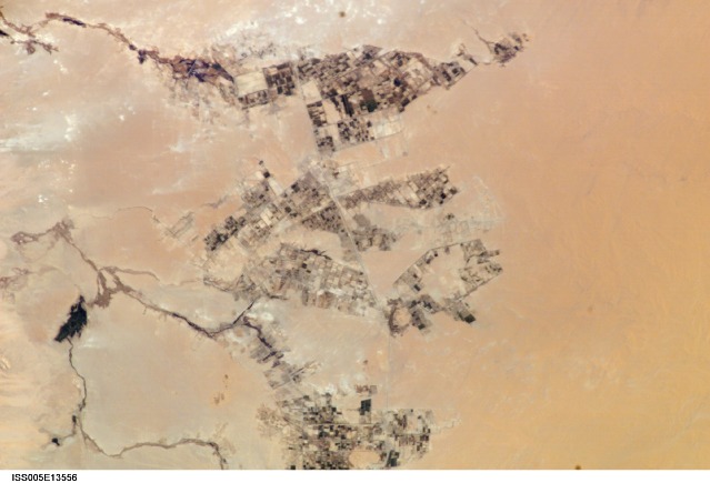
Spacecraft nadir point: 25.8° N, 29.1° E
Photo center point: 26.8° N, 27.9° E
Photo center point by machine learning:
Photo center point: 26.8° N, 27.9° E
Photo center point by machine learning:
Nadir to Photo Center: Northwest
Spacecraft Altitude: 209 nautical miles (387km)
Country or Geographic Name: | EGYPT |
Features: | PUBLIC INPUTS (from public image detectives, not NASA): (26.83,27.87), AFRICA, EGYPT, FARMS, FARAFRA, AL FARAFRA-AL WAHAT ROAD,CENTER POINT IS IN THE EGYPTIAN DESERT SOUTHWEAT OF QASR FARAFRA AND NORTHEAST OF ABU MINOAR,QASR FARAFRA CY., EGYPT,EGYPT, WESTERN DESERT, WHITE DESERT, FARAFRA OASIS,QASR FARAFRA |
| Features Found Using Machine Learning: | |
Cloud Cover Percentage: | 0 (no clouds present) |
Sun Elevation Angle: | 53° |
Sun Azimuth: | 120° |
Camera: | Kodak DCS760c Electronic Still Camera |
Focal Length: | 400mm |
Camera Tilt: | 25 degrees |
Format: | 3060E: 3060 x 2036 pixel CCD, RGBG array |
Film Exposure: | |
| Additional Information | |
| Width | Height | Annotated | Cropped | Purpose | Links |
|---|---|---|---|---|---|
| 3032 pixels | 2064 pixels | No | No | Download Image | |
| 639 pixels | 435 pixels | No | No | Download Image |
Download Packaged File
Download a Google Earth KML for this Image
View photo footprint information
Download a GeoTIFF for this photo
Image Caption: none
