ISS005-E-12209
| NASA Photo ID | ISS005-E-12209 |
| Focal Length | 400mm |
| Date taken | 2002.09.02 |
| Time taken | 19:15:21 GMT |

Cloud masks available for this image:
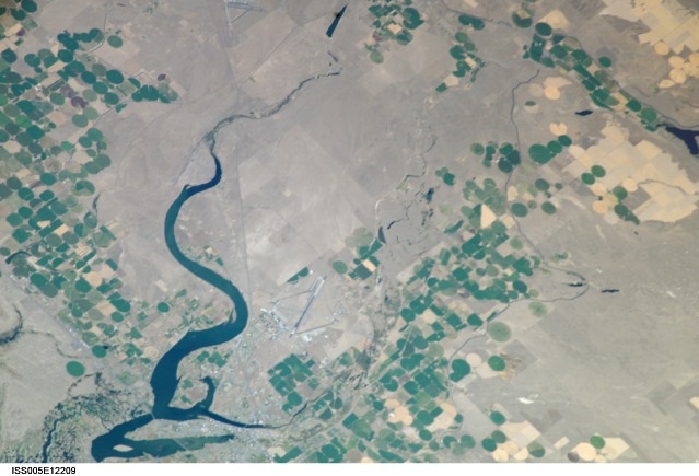
Spacecraft nadir point: 44.1° N, 116.8° W
Photo center point: 47.3° N, 119.3° W
Photo center point by machine learning:
Photo center point: 47.3° N, 119.3° W
Photo center point by machine learning:
Nadir to Photo Center: Northwest
Spacecraft Altitude: 208 nautical miles (385km)
Country or Geographic Name: | USA-WASHINGTON |
Features: | PUBLIC INPUTS (from public image detectives, not NASA): MOSES LAKE, I-90. WA-17, GRANT COUNTY INTERNATIONAL AIRPORT, PELICAN HORN, PARKER HORN, EPHRATA MUNICIPAL AIRPORT, EPHRATA LAKE,CENTER POINT IS NORTH OF MOSES LAKE, WASHINGTON AND NORTH OF MOSES LAKE,MOSES LAKE WA |
| Features Found Using Machine Learning: | |
Cloud Cover Percentage: | 10 (1-10)% |
Sun Elevation Angle: | 53° |
Sun Azimuth: | 167° |
Camera: | Kodak DCS760c Electronic Still Camera |
Focal Length: | 400mm |
Camera Tilt: | 49 degrees |
Format: | 3060E: 3060 x 2036 pixel CCD, RGBG array |
Film Exposure: | |
| Additional Information | |
| Width | Height | Annotated | Cropped | Purpose | Links |
|---|---|---|---|---|---|
| 3032 pixels | 2064 pixels | No | No | Download Image | |
| 639 pixels | 435 pixels | No | No | Download Image |
Download Packaged File
Download a Google Earth KML for this Image
View photo footprint information
Download a GeoTIFF for this photo
Image Caption: none
