ISS004-E-10921

| NASA Photo ID | ISS004-E-10921 |
| Focal Length | 24mm |
| Date taken | 2002.04.29 |
| Time taken | 21:32:52 GMT |
Resolutions offered for this image:
1024 x 768 pixels 540 x 374 pixels 540 x 358 pixels 1000 x 681 pixels 3032 x 2064 pixels 639 x 435 pixels
1024 x 768 pixels 540 x 374 pixels 540 x 358 pixels 1000 x 681 pixels 3032 x 2064 pixels 639 x 435 pixels

Cloud masks available for this image:
Spacecraft nadir point: 46.3° N, 120.6° W
Photo center point: 48.5° N, 122.5° W
Photo center point by machine learning:
Photo center point: 48.5° N, 122.5° W
Photo center point by machine learning:
Nadir to Photo Center: Northwest
Spacecraft Altitude: 209 nautical miles (387km)
Country or Geographic Name: | USA-WASHINGTON |
Features: | PUGET SOUND, OLYMPIC PENINSULA |
| Features Found Using Machine Learning: | |
Cloud Cover Percentage: | 10 (1-10)% |
Sun Elevation Angle: | 53° |
Sun Azimuth: | 219° |
Camera: | Kodak DCS760c Electronic Still Camera |
Focal Length: | 24mm |
Camera Tilt: | 40 degrees |
Format: | 3060E: 3060 x 2036 pixel CCD, RGBG array |
Film Exposure: | |
| Additional Information | |
| Width | Height | Annotated | Cropped | Purpose | Links |
|---|---|---|---|---|---|
| 1024 pixels | 768 pixels | Photographic Highlights | Download Image | ||
| 540 pixels | 374 pixels | Photographic Highlights | Download Image | ||
| 540 pixels | 358 pixels | Yes | Yes | Earth From Space collection | Download Image |
| 1000 pixels | 681 pixels | No | No | NASA's Earth Observatory web site | Download Image |
| 3032 pixels | 2064 pixels | No | No | Download Image | |
| 639 pixels | 435 pixels | No | No | Download Image |
Download Packaged File
Download a Google Earth KML for this Image
View photo footprint information
Download a GeoTIFF for this photo
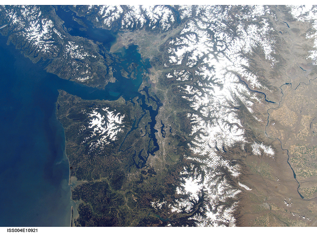
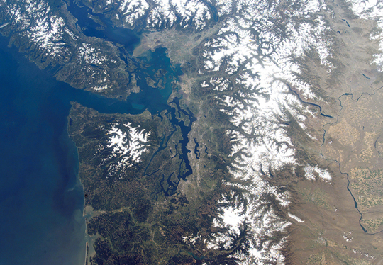
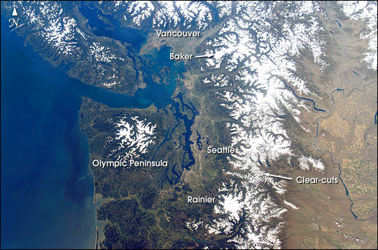
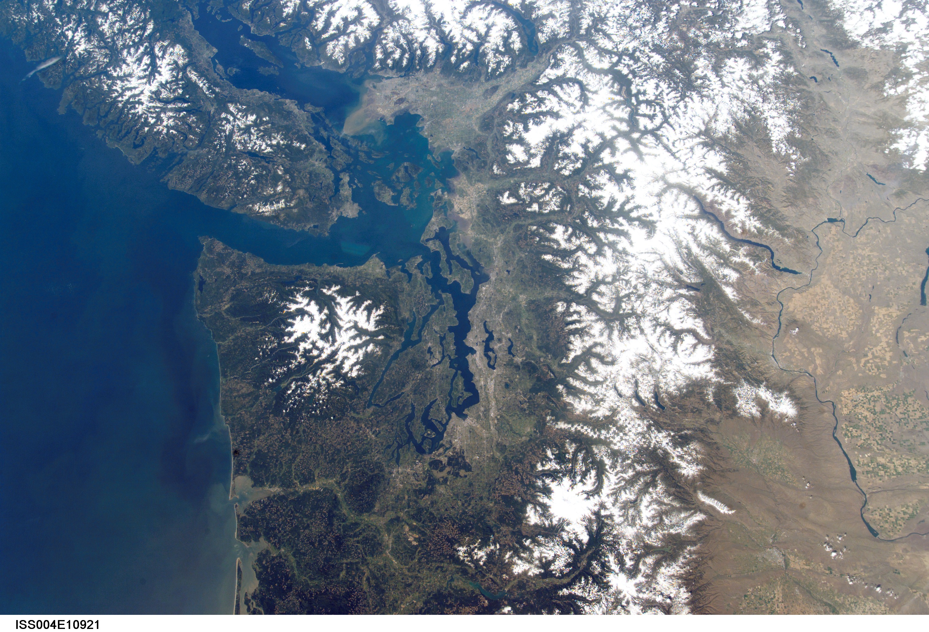
Image Caption: This cloudless view of northwestern Washington and southeastern British Columbia is a study in varied land-use patterns: the forested Olympic Peninsula and Cascade Range contrast with the wheatlands of the drier east side of the mountains. The checkerboard pattern of clearcut forest is accented by snow in the range east of Seattle. Major cities and seaports of the Pacific Northwest--Seattle, Tacoma and Vancouver--take advantage of the deep, sheltered channels.
The natural beauty and safe harbors of the region are products of tectonic processes acting on the western margin of North America. Mt. Rainier and Mt. Baker are just two in a line of recently active volcanoes extending from the Coast Mountains of British Columbia to Mt. Shasta in northern California. Strong earthquakes are also frequent, as exemplified by the Nisqually quake (magnitude Mw 6.8) of February 28, 2001, which rocked Tacoma, Seattle and the surrounding area.
Information Source: Nisqually Earthquake Information Clearinghouse: //maximus.ce.washington.edu/~nisqually/
