ISS002-E-9309
| NASA Photo ID | ISS002-E-9309 |
| Focal Length | 800mm |
| Date taken | 2001.07.09 |
| Time taken | 18:00:00 GMT |
Resolutions offered for this image:
540 x 405 pixels 2249 x 1705 pixels 540 x 533 pixels 3060 x 2092 pixels 640 x 437 pixels 400 x 300 pixels
540 x 405 pixels 2249 x 1705 pixels 540 x 533 pixels 3060 x 2092 pixels 640 x 437 pixels 400 x 300 pixels

Cloud masks available for this image:
Spacecraft nadir point: 21.9° N, 61.7° W
Photo center point: 16.5° N, 62.0° W
Photo center point by machine learning:
Photo center point: 16.5° N, 62.0° W
Photo center point by machine learning:
Nadir to Photo Center: South
Spacecraft Altitude: 204 nautical miles (378km)
Country or Geographic Name: | LESSER ANTILLES |
Features: | MONTSERRAT, PLUME, LAHARS |
| Features Found Using Machine Learning: | |
Cloud Cover Percentage: | 10 (1-10)% |
Sun Elevation Angle: | 65° |
Sun Azimuth: | 276° |
Camera: | Kodak DCS460 Electronic Still Camera |
Focal Length: | 800mm |
Camera Tilt: | High Oblique |
Format: | 3060E: 3060 x 2036 pixel CCD, RGBG array |
Film Exposure: | |
| Additional Information | |
| Width | Height | Annotated | Cropped | Purpose | Links |
|---|---|---|---|---|---|
| 540 pixels | 405 pixels | Yes | Yes | Earth From Space collection | Download Image |
| 2249 pixels | 1705 pixels | No | No | NASA's Earth Observatory web site | Download Image |
| 540 pixels | 533 pixels | No | Yes | Download Image | |
| 3060 pixels | 2092 pixels | No | No | Download Image | |
| 640 pixels | 437 pixels | No | No | Download Image | |
| 400 pixels | 300 pixels | Yes | Yes | Photographic Highlights | Download Image |
Download Packaged File
Download a Google Earth KML for this Image
View photo footprint information
Download a GeoTIFF for this photo
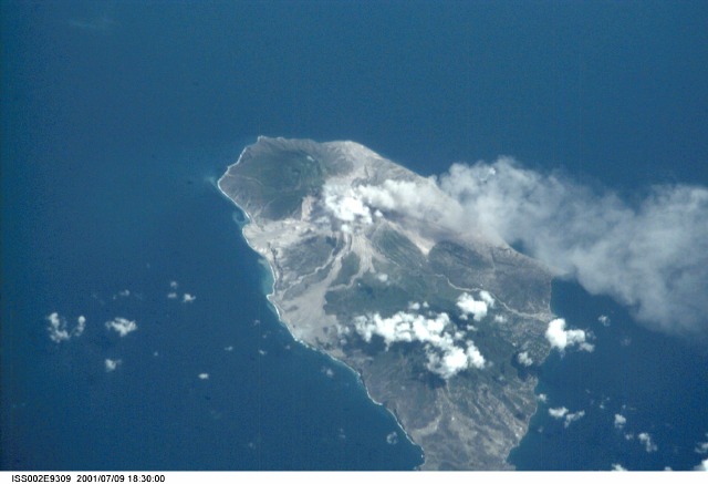
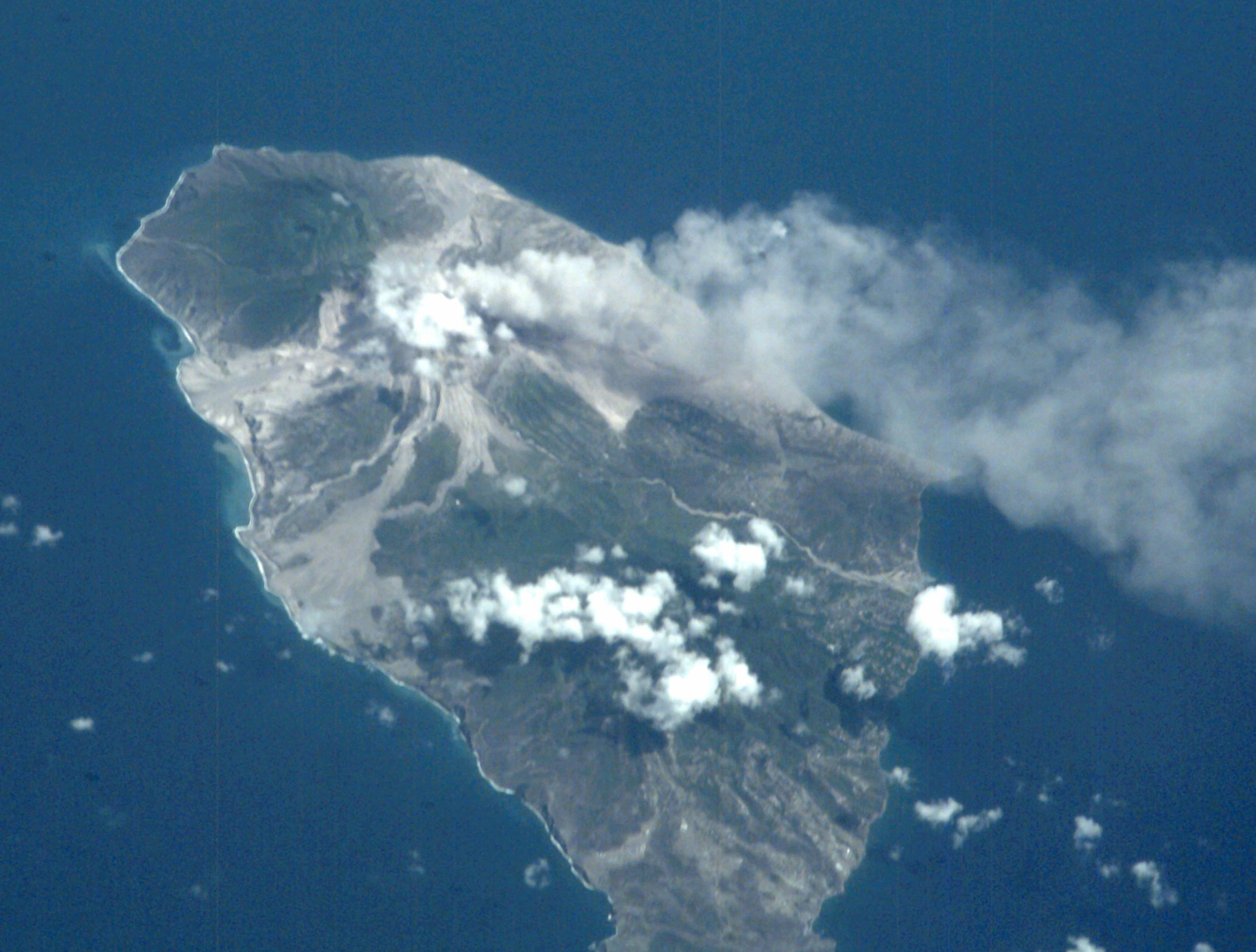
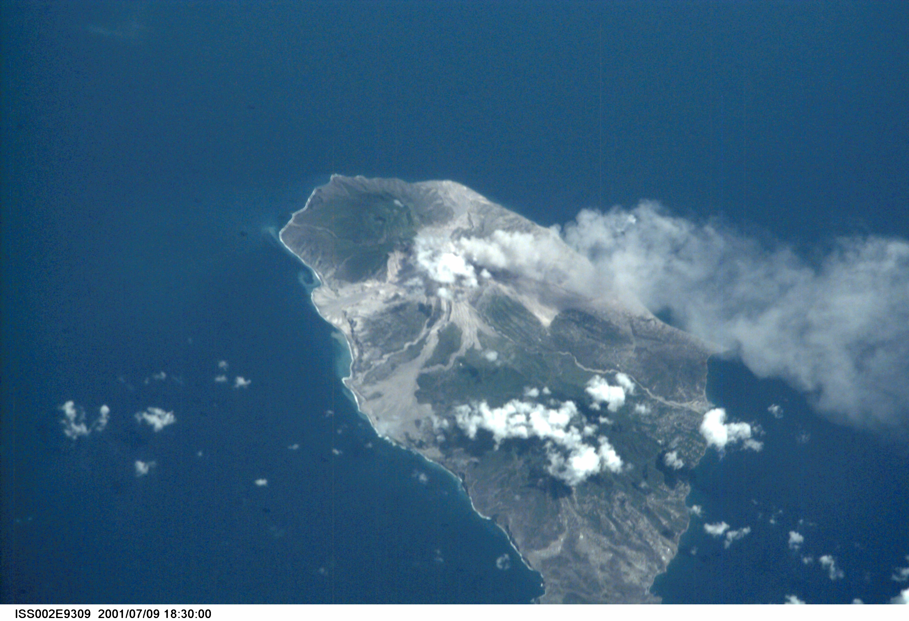
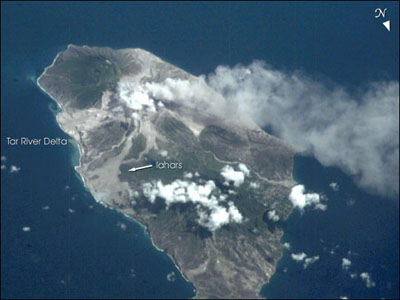
Image Caption: ISS002-E-9309 Montserrat, Lesser Antilles July 2001
Volcanic activity on the West Indian island of Montserrat has remained high for several years--the current activity started in 1995. However, remote sensing of the island has been difficult because of frequent cloud cover. The International Space Station crew flew north of the island on a clear day in early July (July 9, 2001) and recorded a vigorous steam plume emanating from the summit of Soufriere Hills. The image also reveals the extensive volcanic mud flows (lahars) and new deltas built out from the coast from the large amounts of volcanic debris delivered downstream by the rivers draining the mountain. As a small island (only 13 x 8 km), all of Montserrat has been impacted by the eruptions.
Volcanic activity on the West Indian island of Montserrat has remained high for several years--the current activity started in 1995. However, remote sensing of the island has been difficult because of frequent cloud cover. The International Space Station crew flew north of the island on a clear day in early July (July 9, 2001) and recorded a vigorous steam plume emanating from the summit of Soufriere Hills. The image also reveals the extensive volcanic mud flows (lahars) and new deltas built out from the coast from the large amounts of volcanic debris delivered downstream by the rivers draining the mountain. As a small island (only 13 x 8 km), all of Montserrat has been impacted by the eruptions.
