ISS002-E-9147

| NASA Photo ID | ISS002-E-9147 |
| Focal Length | 35mm |
| Date taken | 2001.06.30 |
| Time taken | 11:32:14 GMT |
Resolutions offered for this image:
1024 x 700 pixels 540 x 369 pixels 540 x 395 pixels 3060 x 2092 pixels 640 x 437 pixels 400 x 293 pixels
1024 x 700 pixels 540 x 369 pixels 540 x 395 pixels 3060 x 2092 pixels 640 x 437 pixels 400 x 293 pixels


Cloud masks available for this image:
Spacecraft nadir point: 32.0° N, 80.3° E
Photo center point: 45.0° N, 60.5° E
Photo center point by machine learning:
Photo center point: 45.0° N, 60.5° E
Photo center point by machine learning:
Nadir to Photo Center: Northwest
Spacecraft Altitude: 202 nautical miles (374km)
Country or Geographic Name: | KAZAKHSTAN |
Features: | ARAL SEA, DUST STORM |
| Features Found Using Machine Learning: | |
Cloud Cover Percentage: | 10 (1-10)% |
Sun Elevation Angle: | 26° |
Sun Azimuth: | 282° |
Camera: | Kodak DCS460 Electronic Still Camera |
Focal Length: | 35mm |
Camera Tilt: | High Oblique |
Format: | 3060E: 3060 x 2036 pixel CCD, RGBG array |
Film Exposure: | |
| Additional Information | |
| Width | Height | Annotated | Cropped | Purpose | Links |
|---|---|---|---|---|---|
| 1024 pixels | 700 pixels | Photographic Highlights | Download Image | ||
| 540 pixels | 369 pixels | Photographic Highlights | Download Image | ||
| 540 pixels | 395 pixels | Yes | Yes | Earth From Space collection | Download Image |
| 3060 pixels | 2092 pixels | No | No | Download Image | |
| 640 pixels | 437 pixels | No | No | Download Image | |
| 400 pixels | 293 pixels | Yes | Photographic Highlights | Download Image |
Download Packaged File
Download a Google Earth KML for this Image
View photo footprint information
Download a GeoTIFF for this photo
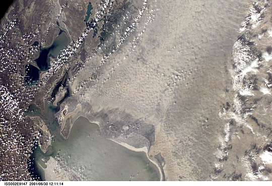
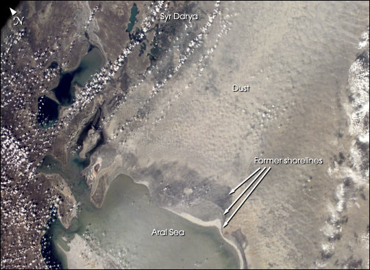
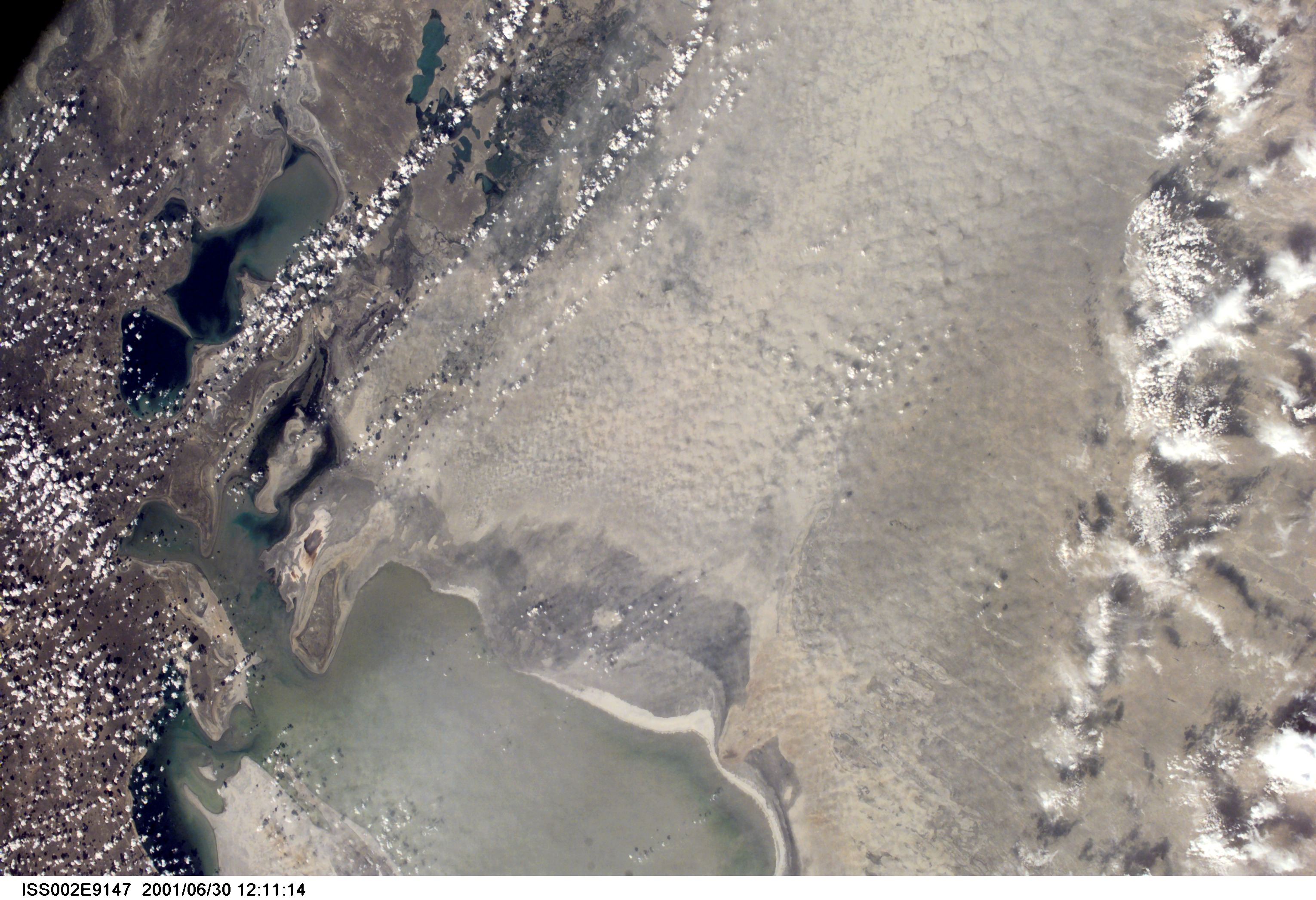
Image Caption: The Aral Sea has shrunk to less than half its size since 1985. The Aral Sea receives little water sometimes no water) from the two major rivers that empty into it-the Syr Darya and Amu Darya. Instead, the river water is diverted to support irrigation for the region's extensive cotton fields. Recently, water scarcity has increased due to a prolonged drought in Central Asia. As the Aral Sea recedes, its former sea bed is exposed. The Aral's sea bed is composed of fine sediments-including fertilizers and other agricultural chemicals-that are easily picked up by the region's strong winds, creating thick dust storms. The International Space Station crew observed and recorded a large dust storm blowing eastward from the Aral Sea in late June 2001. This image illustrates the strong coupling between human activities (water diversions and irrigation), and rapidly changing land, sea and atmospheric processes-the winds blow across the Sea and pick up dust (former sea bottom sediments) as soon as the blowing air masses hit land. Note that the northern boundary of the dust storm occurs along the Syr Darya, where no bottom sediments are exposed.
