ISS002-E-6169
| NASA Photo ID | ISS002-E-6169 |
| Focal Length | 800mm |
| Date taken | 2001.05.06 |
| Time taken | 13:01:38 GMT |
Resolutions offered for this image:
1024 x 700 pixels 540 x 369 pixels 507 x 520 pixels 506 x 521 pixels 3060 x 2092 pixels 640 x 437 pixels 400 x 411 pixels
1024 x 700 pixels 540 x 369 pixels 507 x 520 pixels 506 x 521 pixels 3060 x 2092 pixels 640 x 437 pixels 400 x 411 pixels

Cloud masks available for this image:
Spacecraft nadir point: 43.6° N, 72.6° W
Photo center point: 40.5° N, 74.0° W
Photo center point by machine learning:
Photo center point: 40.5° N, 74.0° W
Photo center point by machine learning:
Nadir to Photo Center: South
Spacecraft Altitude: 203 nautical miles (376km)
Country or Geographic Name: | USA-NEW YORK |
Features: | NEW YORK, MANHATTAN I. |
| Features Found Using Machine Learning: | |
Cloud Cover Percentage: | 10 (1-10)% |
Sun Elevation Angle: | 36° |
Sun Azimuth: | 101° |
Camera: | Kodak DCS460 Electronic Still Camera |
Focal Length: | 800mm |
Camera Tilt: | 45 degrees |
Format: | 3060E: 3060 x 2036 pixel CCD, RGBG array |
Film Exposure: | |
| Additional Information | |
| Width | Height | Annotated | Cropped | Purpose | Links |
|---|---|---|---|---|---|
| 1024 pixels | 700 pixels | Photographic Highlights | Download Image | ||
| 540 pixels | 369 pixels | Photographic Highlights | Download Image | ||
| 507 pixels | 520 pixels | Photographic Highlights | Download Image | ||
| 506 pixels | 521 pixels | Photographic Highlights | Download Image | ||
| 3060 pixels | 2092 pixels | No | No | Download Image | |
| 640 pixels | 437 pixels | No | No | Download Image | |
| 400 pixels | 411 pixels | Yes | Photographic Highlights | Download Image |
Download Packaged File
Download a Google Earth KML for this Image
View photo footprint information
Download a GeoTIFF for this photo
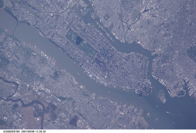
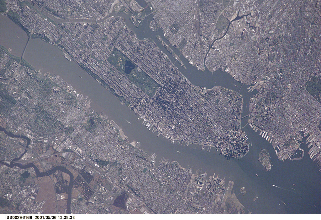
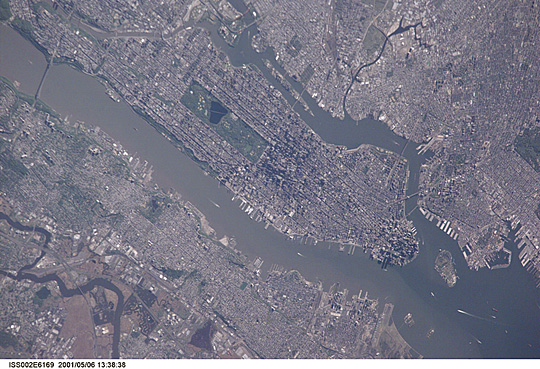
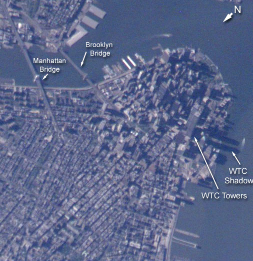
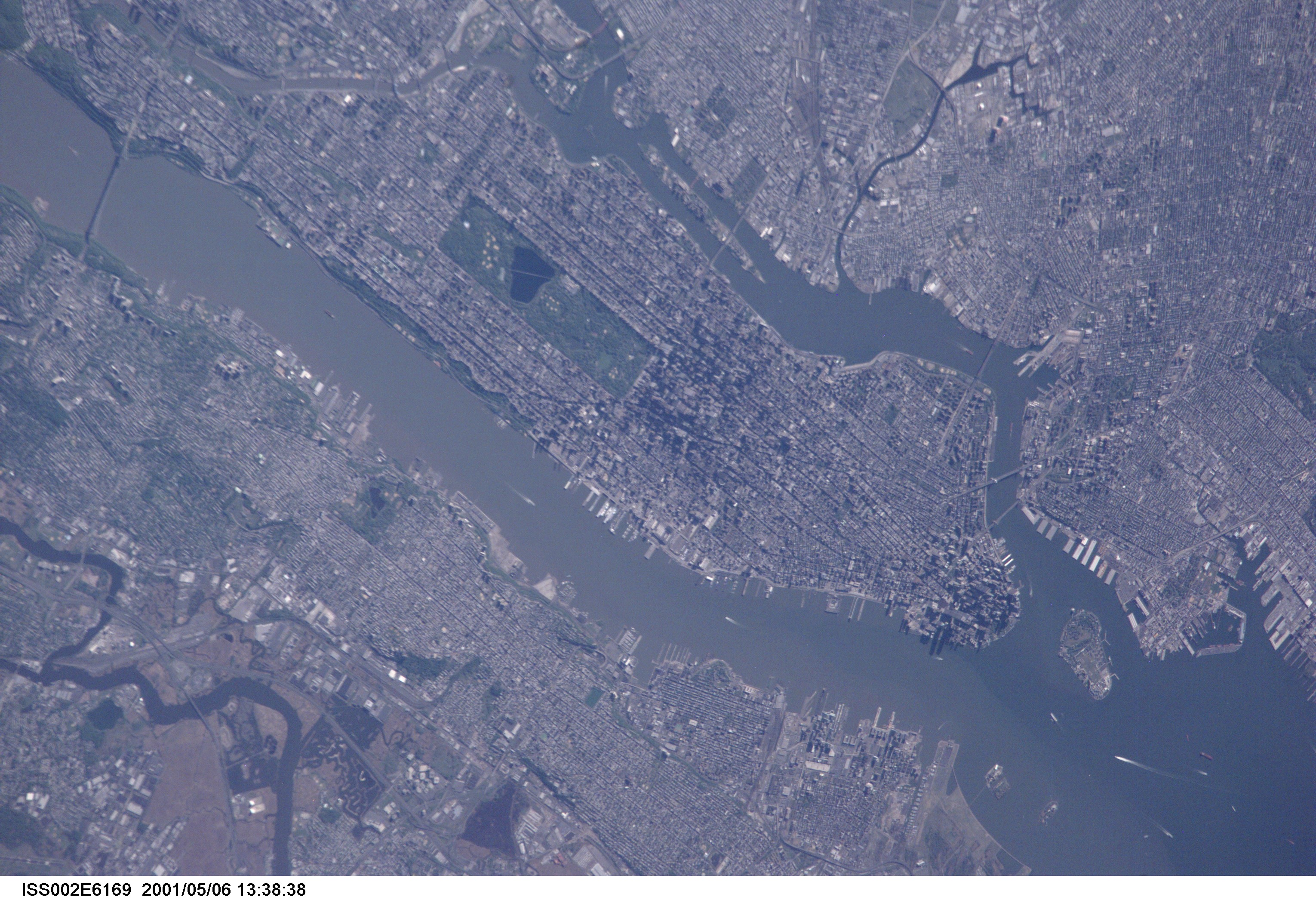
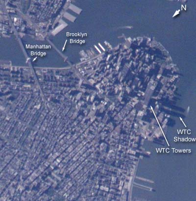
Image Caption: Lower Manhattan
ISS Expedition 2 crew members photographed Manhattan Island on an exceptionally clear spring day. The clarity and detail of the image provides a bird's-eye view of lower Manhattan's financial district, including the two World Trade Center (WTC) Towers. The early morning sun (the image was taken May 6, 2001 at about 9:00 AM, EDT) illuminates the east side of 110-story buildings, and casts long shadows over the Hudson River. The image provides some geographic context for tragedy that occurred on September 11. Only part of the complete image is shown above. Expedition 3 crew members photographed the area again shortly after the collapse of the towers (ISS003-E-5588).
ISS Expedition 2 crew members photographed Manhattan Island on an exceptionally clear spring day. The clarity and detail of the image provides a bird's-eye view of lower Manhattan's financial district, including the two World Trade Center (WTC) Towers. The early morning sun (the image was taken May 6, 2001 at about 9:00 AM, EDT) illuminates the east side of 110-story buildings, and casts long shadows over the Hudson River. The image provides some geographic context for tragedy that occurred on September 11. Only part of the complete image is shown above. Expedition 3 crew members photographed the area again shortly after the collapse of the towers (ISS003-E-5588).
