AS09-25-3682
| NASA Photo ID | AS09-25-3682 |
| Focal Length | 80mm |
| Date taken | 1969.03.08 |
| Time taken | 19:25:00 GMT |

Cloud masks available for this image:
Spacecraft nadir point:
Photo center point: 12.2° N, 61.8° W
Photo center point by machine learning:
Photo center point: 12.2° N, 61.8° W
Photo center point by machine learning:
Nadir to Photo Center:
Spacecraft Altitude: 123 nautical miles (228km)
Country or Geographic Name: | LESSER ANTILLES |
Features: | GRENADA |
| Features Found Using Machine Learning: | |
Cloud Cover Percentage: | 10 (1-10)% |
Sun Elevation Angle: | 43° |
Sun Azimuth: | ° |
Camera: | Hasselblad |
Focal Length: | 80mm |
Camera Tilt: | Near Vertical |
Format: | SO368: Kodak Ektachrome MS, equivalent to 2448 Kodak Aerochrome, ASA64, thin base, fine grain |
Film Exposure: | Normal |
| Additional Information | |
| Width | Height | Annotated | Cropped | Purpose | Links |
|---|---|---|---|---|---|
| 4400 pixels | 4600 pixels | No | No | Download Image | |
| 492 pixels | 515 pixels | No | No | Download Image |
Download Packaged File
Download a Google Earth KML for this Image
View photo footprint information
Download a GeoTIFF for this photo
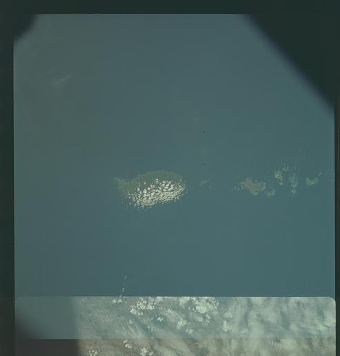
Image Caption: GEOGRAPHY/CARTOGRAPHY: WINDWARD ISLANDS, ISLAND OF GRENADA LOOKING SOUTH, POINT SALINES, CITY OF ST. GEORGE'S CARRIACON ISLAND, GRENADA TROUGH WEST OF GRENADA ISLAND.
GEOLOGY/HYDROLOGY: VOLCANIC ISLANDS WITH ADJACENT CORAL REEFS.
FORESTRY: TROPICAL RAINFOREST (DENSE)
METEOROLOGY: CUMULUS CLOUD BUILDUP WINDWARD SIDE OF GRENADA ISLAND.
OCEANOGRAPHY:
GEOLOGY/HYDROLOGY: VOLCANIC ISLANDS WITH ADJACENT CORAL REEFS.
FORESTRY: TROPICAL RAINFOREST (DENSE)
METEOROLOGY: CUMULUS CLOUD BUILDUP WINDWARD SIDE OF GRENADA ISLAND.
OCEANOGRAPHY:
