AS09-20-3143
| NASA Photo ID | AS09-20-3143 |
| Focal Length | 80mm |
| Date taken | 1969.03.12 |
| Time taken | 16:31:00 GMT |

Cloud masks available for this image:
Spacecraft nadir point:
Photo center point: 33.7° N, 101.8° W
Photo center point by machine learning:
Photo center point: 33.7° N, 101.8° W
Photo center point by machine learning:
Nadir to Photo Center:
Spacecraft Altitude: 118 nautical miles (219km)
Country or Geographic Name: | USA-TEXAS |
Features: | LUBBOCK, LLANO ESTACADO |
| Features Found Using Machine Learning: | |
Cloud Cover Percentage: | 0 (no clouds present) |
Sun Elevation Angle: | 45° |
Sun Azimuth: | ° |
Camera: | Hasselblad |
Focal Length: | 80mm |
Camera Tilt: | Near Vertical |
Format: | SO368: Kodak Ektachrome MS, equivalent to 2448 Kodak Aerochrome, ASA64, thin base, fine grain |
Film Exposure: | Normal |
| Additional Information | |
| Width | Height | Annotated | Cropped | Purpose | Links |
|---|---|---|---|---|---|
| 4400 pixels | 4600 pixels | No | No | Download Image | |
| 492 pixels | 515 pixels | No | No | Download Image |
Download Packaged File
Download a Google Earth KML for this Image
View photo footprint information
Download a GeoTIFF for this photo
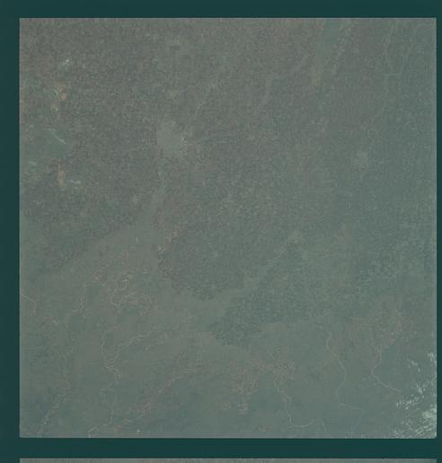
Image Caption: Hand-held, color; southeastern rim of the Plains. Lubbock, Brownfield, Tahoka.
GEOGRAPHY/CARTOGRAPHY: UNITED STATES, TEXAS, ESTACADO PLAIN, CITIES OF LUBBOCK AND PLAINVIEW. GEOLOGY/HYDROLOGY: SEDIMENTARY ELEVATED LIMESTONE PLAINS CAPPING THE LOWER GYPSUM AND RED BED PLAINS.
AGRICULTURE: HEAVY FIELD PATTERN CONCENTRATION, EXTENSIVE CULTIVATION.
FORESTRY: GRASSLANDS WITH SCATTERED SHRUBFORM.
METEOROLOGY: CIRRO-CUMULUS
