< STS047-82-79 >

| NASA Photo ID | STS047-82-79 |
| Focal Length | 100mm |
| Date taken | 1992.09.18 |
| Time taken | 05:09:58 GMT |

Cloud masks available for this image:
Spacecraft nadir point: 45.7° N, 145.3° E
Photo center point: 42.5° N, 140.5° E
Photo center point by machine learning:
Photo center point: 42.5° N, 140.5° E
Photo center point by machine learning:
Nadir to Photo Center: Southwest
Spacecraft Altitude: 170 nautical miles (315km)
Country or Geographic Name: | JAPAN |
Features: | HOKKAIDO-UCHIURA B., SNGT |
| Features Found Using Machine Learning: | |
Cloud Cover Percentage: | 60 (51-75)% |
Sun Elevation Angle: | 33° |
Sun Azimuth: | 236° |
Camera: | Hasselblad |
Focal Length: | 100mm |
Camera Tilt: | High Oblique |
Format: | VELVI: Fuji, natural color positive, Velvia 50, CS 135-36, ASA 32, standard base |
Film Exposure: | Normal |
| Additional Information | |
| Width | Height | Annotated | Cropped | Purpose | Links |
|---|---|---|---|---|---|
| 5700 pixels | 6000 pixels | No | No | Download Image Download Color Calibration Image for this Image |
|
| 500 pixels | 526 pixels | No | No | Download Image Download Color Calibration Image for this Image |
|
| 640 pixels | 480 pixels | No | No | Download Image |
Download Packaged File
Download a Google Earth KML for this Image
View photo footprint information
No GeoTIFF is available for this photo.Image Caption:
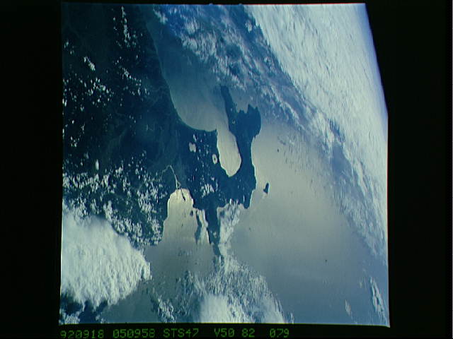
STS047-82-079 SAPPORO, Hokkaido, Japan. The city of Sapporo lies
at the base of the convoluted peninsula at the south end of the
island of Hokkaido. Volcano Bay is the large bay surrounded by
the peninsula. Sapporo is the hometown of Japan's first as-
tronaut, Dr. Mamoru Mohri.
STS047-82-079 Hokkaido. Sunglint off the ocean rings southern
Hokkaido in this oblique view to the south. Sapporo can be seen
as can two crater lakes along the southern coast.
