< STS081-728-55 >

| NASA Photo ID | STS081-728-55 |
| Focal Length | 250mm |
| Date taken | 1997.01.20 |
| Time taken | 16:24:16 GMT |
Resolutions offered for this image:
4012 x 4012 pixels 639 x 639 pixels 5700 x 5900 pixels 483 x 500 pixels 520 x 513 pixels
4012 x 4012 pixels 639 x 639 pixels 5700 x 5900 pixels 483 x 500 pixels 520 x 513 pixels


Cloud masks available for this image:
Spacecraft nadir point: 14.0° N, 89.9° W
Photo center point: 14.5° N, 90.5° W
Photo center point by machine learning:
Photo center point: 14.5° N, 90.5° W
Photo center point by machine learning:
Nadir to Photo Center: Northwest
Spacecraft Altitude: 191 nautical miles (354km)
Country or Geographic Name: | GUATEMALA |
Features: | GUATEMALA CITY, VOLCANO |
| Features Found Using Machine Learning: | |
Cloud Cover Percentage: | 10 (1-10)% |
Sun Elevation Angle: | 47° |
Sun Azimuth: | 142° |
Camera: | Hasselblad |
Focal Length: | 250mm |
Camera Tilt: | 14 degrees |
Format: | 5046: Kodak, natural color positive, Lumiere 100/5046, ASA 100, standard base |
Film Exposure: | Normal |
| Additional Information | |
| Width | Height | Annotated | Cropped | Purpose | Links |
|---|---|---|---|---|---|
| 4012 pixels | 4012 pixels | No | No | Earth From Space collection | Download Image |
| 639 pixels | 639 pixels | No | No | Earth From Space collection | Download Image |
| 5700 pixels | 5900 pixels | No | No | Download Image | |
| 483 pixels | 500 pixels | No | No | Download Image | |
| 520 pixels | 513 pixels | No | No | Download Image |
Download Packaged File
Download a Google Earth KML for this Image
View photo footprint information
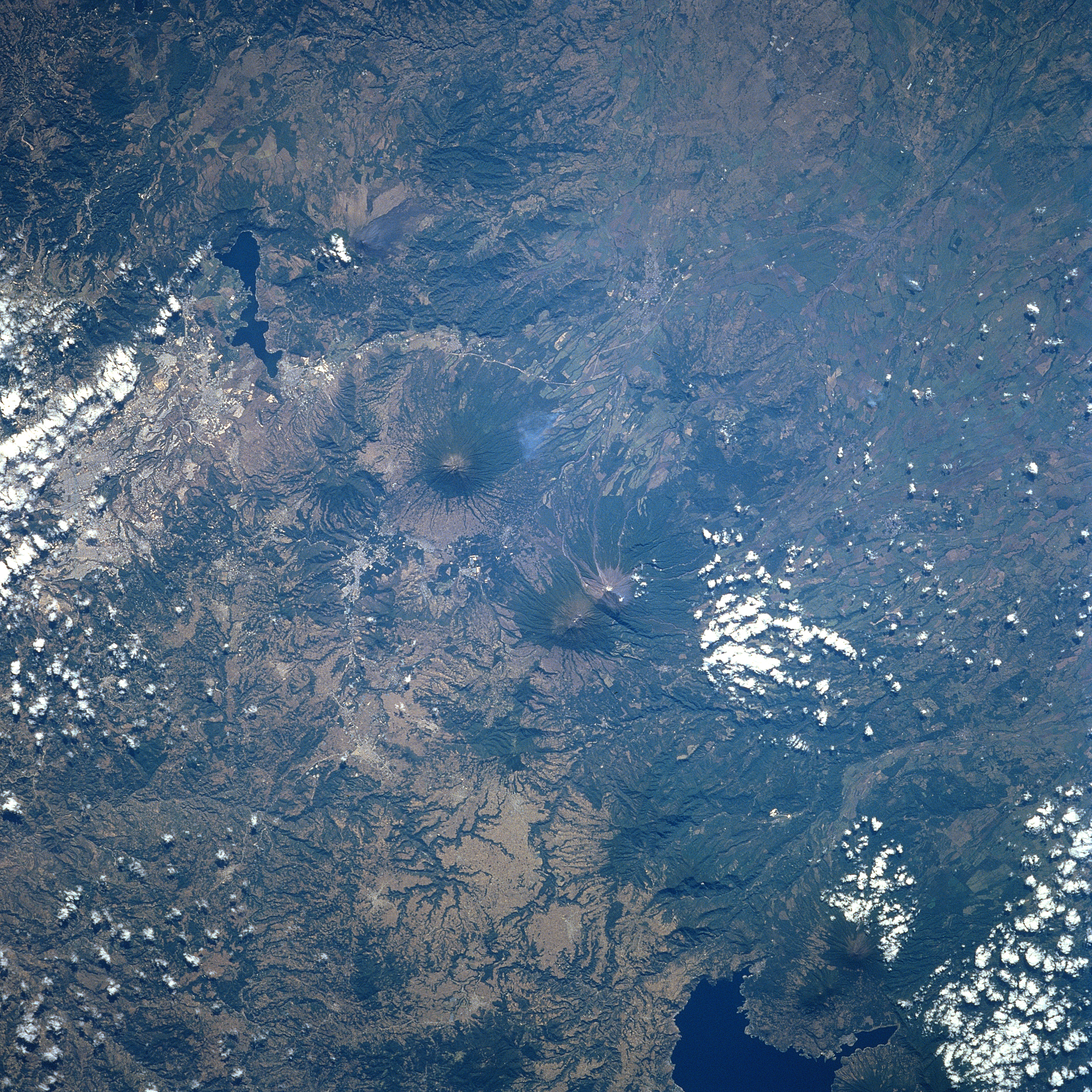
No GeoTIFF is available for this photo.Image Caption: STS081-728-055 Volcanoes, Guatemala January 1997
The two prominent stratovolcanoes near the center of the picture (look for the radial drainage) are Acatenango (west) and Fuego (east). Their respective summit elevations are 13,045 feet (3976 meters) and 12,336 feet (3760 meters) above sea level. These volcanoes are part of a volcanic belt, which is aligned northwest to southeast near the west coast of Central America. The volcanic belt is the result of the Cocos Plate and a small piece of the Nazca Plate being subducted under the Caribbean Plate. This image graphically shows the volcanic axis that extends from Lago (lake) Atitlan (dark feature, bottom right) southeasterly to beyond the smaller lake (dark feature) south of the lighter colored landscape of Guatemala City (middle left edge-not to be confused with the white clouds). The darker-looking mountainous terrain and the flanks of the volcanoes are covered by lush forest vegetation.
The two prominent stratovolcanoes near the center of the picture (look for the radial drainage) are Acatenango (west) and Fuego (east). Their respective summit elevations are 13,045 feet (3976 meters) and 12,336 feet (3760 meters) above sea level. These volcanoes are part of a volcanic belt, which is aligned northwest to southeast near the west coast of Central America. The volcanic belt is the result of the Cocos Plate and a small piece of the Nazca Plate being subducted under the Caribbean Plate. This image graphically shows the volcanic axis that extends from Lago (lake) Atitlan (dark feature, bottom right) southeasterly to beyond the smaller lake (dark feature) south of the lighter colored landscape of Guatemala City (middle left edge-not to be confused with the white clouds). The darker-looking mountainous terrain and the flanks of the volcanoes are covered by lush forest vegetation.
