< STS087-701-37 >

| NASA Photo ID | STS087-701-37 |
| Focal Length | 100mm |
| Date taken | 1997.11.21 |
| Time taken | 03:07:30 GMT |
Resolutions offered for this image:
4096 x 4096 pixels 640 x 640 pixels 5700 x 5900 pixels 483 x 500 pixels 637 x 639 pixels
4096 x 4096 pixels 640 x 640 pixels 5700 x 5900 pixels 483 x 500 pixels 637 x 639 pixels


Cloud masks available for this image:
Spacecraft nadir point: 16.9° N, 102.9° E
Photo center point: 17.0° N, 102.5° E
Photo center point by machine learning:
Photo center point: 17.0° N, 102.5° E
Photo center point by machine learning:
Nadir to Photo Center: West
Spacecraft Altitude: 151 nautical miles (280km)
Country or Geographic Name: | THAILAND |
Features: | UBOLRATNA RESERVOIR |
| Features Found Using Machine Learning: | |
Cloud Cover Percentage: | 0 (no clouds present) |
Sun Elevation Angle: | 45° |
Sun Azimuth: | 143° |
Camera: | Hasselblad |
Focal Length: | 100mm |
Camera Tilt: | 9 degrees |
Format: | 5069: Kodak Elite 100S, E6 Reversal, Replaces Lumiere, Warmer in tone vs. Lumiere |
Film Exposure: | Normal |
| Additional Information | |
| Width | Height | Annotated | Cropped | Purpose | Links |
|---|---|---|---|---|---|
| 4096 pixels | 4096 pixels | No | No | Earth From Space collection | Download Image |
| 640 pixels | 640 pixels | No | No | Earth From Space collection | Download Image |
| 5700 pixels | 5900 pixels | No | No | Download Image Download Color Calibration Image for this Image |
|
| 483 pixels | 500 pixels | No | No | Download Image Download Color Calibration Image for this Image |
|
| 637 pixels | 639 pixels | No | No | Download Image |
Download Packaged File
Download a Google Earth KML for this Image
View photo footprint information
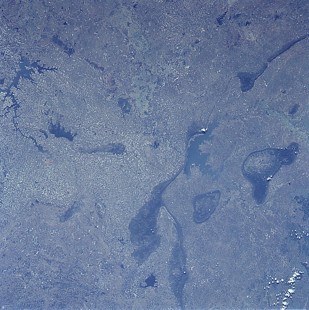
No GeoTIFF is available for this photo.Image Caption: STS087-701-037 Ubolratna Reservoir, Thailand November 1997
The Khorat Plateau, located in northeast Thailand, is an elevated plain that is broken only by an occasional, narrow, isolated mountain ridge (elongated, dark features). These low mountains (average elevations between 1500 feet - 457 meters and 2500 feet - 762 meters above sea level) are seen primarily in the right half (western side) of the image. Recognizable features in the image includes the Ubolratna Reservoir (dark, irregular shaped feature) located slightly right of center; an elongated but irregular shaped Lam Pao Reservoir (dark feature) along the left edge of the image; a small reservoir (dark feature) bottom center; and the linear-looking mountain ridges. The mottled-looking landscape shows the distribution pattern of small rice producing fields.
The Khorat Plateau, located in northeast Thailand, is an elevated plain that is broken only by an occasional, narrow, isolated mountain ridge (elongated, dark features). These low mountains (average elevations between 1500 feet - 457 meters and 2500 feet - 762 meters above sea level) are seen primarily in the right half (western side) of the image. Recognizable features in the image includes the Ubolratna Reservoir (dark, irregular shaped feature) located slightly right of center; an elongated but irregular shaped Lam Pao Reservoir (dark feature) along the left edge of the image; a small reservoir (dark feature) bottom center; and the linear-looking mountain ridges. The mottled-looking landscape shows the distribution pattern of small rice producing fields.
