< STS056-109-30 >

| NASA Photo ID | STS056-109-30 |
| Focal Length | 250mm |
| Date taken | 1993.04.10 |
| Time taken | 15:16:46 GMT |
Resolutions offered for this image:
3904 x 3904 pixels 639 x 639 pixels 5700 x 6000 pixels 500 x 526 pixels 640 x 480 pixels
3904 x 3904 pixels 639 x 639 pixels 5700 x 6000 pixels 500 x 526 pixels 640 x 480 pixels


Cloud masks available for this image:
Spacecraft nadir point: 27.8° N, 100.1° W
Photo center point: 27.5° N, 99.5° W
Photo center point by machine learning:
Photo center point: 27.5° N, 99.5° W
Photo center point by machine learning:
Nadir to Photo Center: Southeast
Spacecraft Altitude: 161 nautical miles (298km)
Country or Geographic Name: | USA-TEXAS |
Features: | LAREDO-NUEVA LAREDO |
| Features Found Using Machine Learning: | |
Cloud Cover Percentage: | 0 (no clouds present) |
Sun Elevation Angle: | 38° |
Sun Azimuth: | 102° |
Camera: | Hasselblad |
Focal Length: | 250mm |
Camera Tilt: | 14 degrees |
Format: | 2443: Kodak Aerochrome 2443, color IR, thin base, EA-5 process thru June 1999, E-6 process afterward |
Film Exposure: | Normal |
| Additional Information | |
| Width | Height | Annotated | Cropped | Purpose | Links |
|---|---|---|---|---|---|
| 3904 pixels | 3904 pixels | No | No | Earth From Space collection | Download Image |
| 639 pixels | 639 pixels | No | No | Earth From Space collection | Download Image |
| 5700 pixels | 6000 pixels | No | No | Download Image Download Color Calibration Image for this Image |
|
| 500 pixels | 526 pixels | No | No | Download Image Download Color Calibration Image for this Image |
|
| 640 pixels | 480 pixels | No | No | Download Image |
Download Packaged File
Download a Google Earth KML for this Image
View photo footprint information
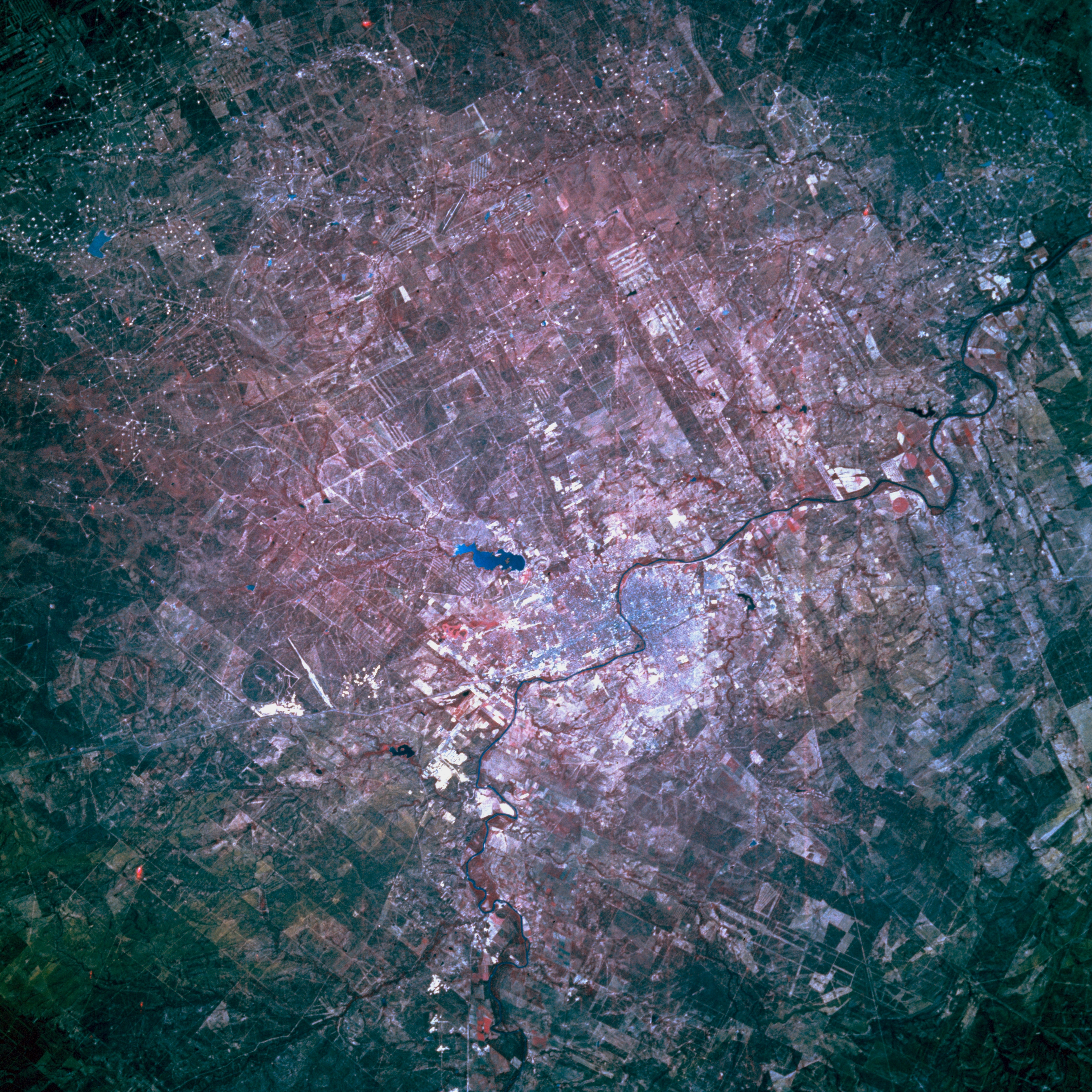
No GeoTIFF is available for this photo.Image Caption: STS056-109-030 Laredo, Texas, U.S.A. April 1993
The border city of Laredo is visible on the east side of the Rio Grande, with Nuevo Laredo, its Mexican counterpart, on the west. Lake Casa Blanca lies northeast of Laredo. The color infrared film does not produce a meaningful rendering of the sandstone and claystone beds that underlie this region of south Texas. White dots (bottom third) show the distribution and density of gas and oil fields. The semiarid climate, receiving less than 20 inches (50 centimeters) of precipitation per year, combined with a very high rate of evaporation promotes the growth of cactus and thornbrush.
The border city of Laredo is visible on the east side of the Rio Grande, with Nuevo Laredo, its Mexican counterpart, on the west. Lake Casa Blanca lies northeast of Laredo. The color infrared film does not produce a meaningful rendering of the sandstone and claystone beds that underlie this region of south Texas. White dots (bottom third) show the distribution and density of gas and oil fields. The semiarid climate, receiving less than 20 inches (50 centimeters) of precipitation per year, combined with a very high rate of evaporation promotes the growth of cactus and thornbrush.
