< ISS008-E-19236 >

| NASA Photo ID | ISS008-E-19236 |
| Focal Length | 195mm |
| Date taken | 2004.03.25 |
| Time taken | 10:04:29 GMT |

Spacecraft nadir point: 13.5° S, 47.3° E
Photo center point: 16.0° S, 46.5° E
Photo center point by machine learning:
Photo center point: 16.0° S, 46.5° E
Photo center point by machine learning:
Nadir to Photo Center: South
Spacecraft Altitude: 196 nautical miles (363km)
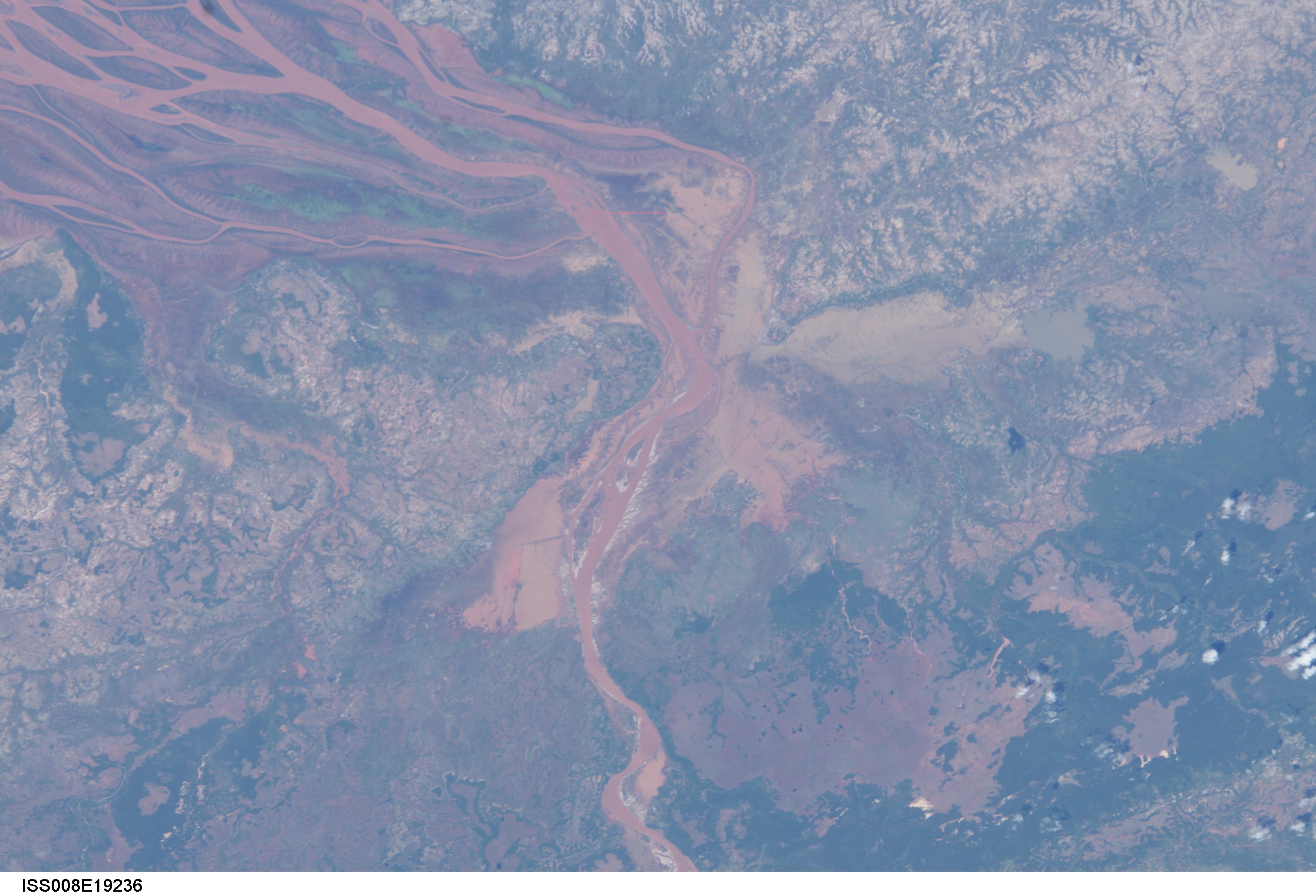
Country or Geographic Name: | MADAGASCAR |
Features: | BETSIBOKA RIVER DELTA, MAROVOAY |
| Features Found Using Machine Learning: | |
Cloud Cover Percentage: | 10 (1-10)% |
Sun Elevation Angle: | 67° |
Sun Azimuth: | 311° |
Camera: | Kodak DCS760c Electronic Still Camera |
Focal Length: | 195mm |
Camera Tilt: | 39 degrees |
Format: | 3060E: 3060 x 2036 pixel CCD, RGBG array |
Film Exposure: | |
| Additional Information | |
| Width | Height | Annotated | Cropped | Purpose | Links |
|---|---|---|---|---|---|
| 3032 pixels | 2064 pixels | No | No | Download Image | |
| 639 pixels | 435 pixels | No | No | Download Image |
Download Packaged File
Download a Google Earth KML for this Image
View photo footprint information
No GeoTIFF is available for this photo.Image Caption: ISS008-E-19236 (25 March 2004) --- This image featuring the Betsiboka estuary on the northwest coast of Madagascar was taken by an Expedition 8 crewmember on the International Space Station (ISS). The Betsiboka estuary is the mouth of Madagascar's largest river and one of the world's fast-changing coastlines. Nearly a century of extensive logging of Madagascar's rainforests and coastal mangroves has resulted in nearly complete clearing of the land and fantastic rates of erosion. After every heavy rain, the bright red soils are washed from the hillsides into the streams and rivers to the coast. Astronauts describe their view of Madagascar as "bleeding into the ocean". One impact of the extensive 20th century erosion is the filling and clogging of coastal waterways with sediment - a process that is well illustrated in the Betsiboka estuary. In fact, ocean-going ships were once able to travel up the Betsiboka estuary, but must now berth at the coast.
