< ISS030-E-19012 >
| NASA Photo ID | ISS030-E-19012 |
| Focal Length | 180mm |
| Date taken | 2011.12.29 |
| Time taken | 20:23:06 GMT |


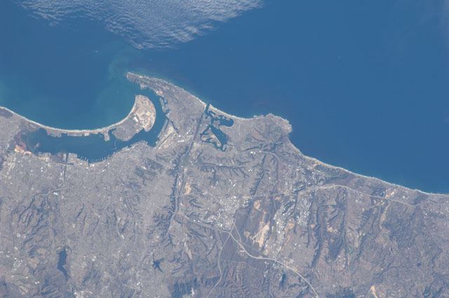
Spacecraft nadir point: 27.8° N, 122.5° W
Photo center point: 32.8° N, 117.2° W
Photo center point by machine learning:
Photo center point: 32.8° N, 117.2° W
Photo center point by machine learning:
Nadir to Photo Center: Northeast
Spacecraft Altitude: 218 nautical miles (404km)
Country or Geographic Name: | USA-CALIFORNIA |
Features: | |
| Features Found Using Machine Learning: | SAN DIEGO |
Cloud Cover Percentage: | 10 (1-10)% |
Sun Elevation Angle: | 39° |
Sun Azimuth: | 183° |
Camera: | Nikon D2Xs Electronic Still Camera |
Focal Length: | 180mm |
Camera Tilt: | High Oblique |
Format: | 4288E: 4288 x 2848 pixel CMOS sensor, RGBG imager color filter |
Film Exposure: | |
| Additional Information | |
| Width | Height | Annotated | Cropped | Purpose | Links |
|---|---|---|---|---|---|
| 4288 pixels | 2848 pixels | No | No | Download Image | |
| 640 pixels | 425 pixels | No | No | Download Image |
Download Packaged File
Download a Google Earth KML for this Image
View photo footprint information
No GeoTIFF is available for this photo.Image Caption: ISS030-E-019012 (29 Dec. 2011) --- This nearly vertical image of the San Diego area was captured by one of the Expedition 30 crew members aboard the International Space Station on Dec. 29, 2011. The United States - Mexico border is just out of view at the left edge of the frame. A 180-mm lens was used to provide detail in the picture.
