< STS085-710-19 >
| NASA Photo ID | STS085-710-19 |
| Focal Length | 100mm |
| Date taken | 1997.08.11 |
| Time taken | 16:44:19 GMT |
Resolutions offered for this image:
4008 x 4085 pixels 627 x 640 pixels 5700 x 5900 pixels 483 x 500 pixels 514 x 503 pixels 480 x 480 pixels
4008 x 4085 pixels 627 x 640 pixels 5700 x 5900 pixels 483 x 500 pixels 514 x 503 pixels 480 x 480 pixels


Cloud masks available for this image:
Spacecraft nadir point: 41.3° N, 119.1° W
Photo center point: 39.0° N, 120.0° W
Photo center point by machine learning:
Photo center point: 39.0° N, 120.0° W
Photo center point by machine learning:
Nadir to Photo Center: South
Spacecraft Altitude: 156 nautical miles (289km)
Country or Geographic Name: | USA-NEVADA |
Features: | LAKE TAHOE |
| Features Found Using Machine Learning: | |
Cloud Cover Percentage: | 0 (no clouds present) |
Sun Elevation Angle: | 40° |
Sun Azimuth: | 107° |
Camera: | Hasselblad |
Focal Length: | 100mm |
Camera Tilt: | 44 degrees |
Format: | 5069: Kodak Elite 100S, E6 Reversal, Replaces Lumiere, Warmer in tone vs. Lumiere |
Film Exposure: | Normal |
| Additional Information | |
| Width | Height | Annotated | Cropped | Purpose | Links |
|---|---|---|---|---|---|
| 4008 pixels | 4085 pixels | No | No | Earth From Space collection | Download Image |
| 627 pixels | 640 pixels | No | No | Earth From Space collection | Download Image |
| 5700 pixels | 5900 pixels | No | No | Download Image Download Color Calibration Image for this Image |
|
| 483 pixels | 500 pixels | No | No | Download Image Download Color Calibration Image for this Image |
|
| 514 pixels | 503 pixels | No | No | Download Image | |
| 480 pixels | 480 pixels | Download Image |
Download Packaged File
Download a Google Earth KML for this Image
View photo footprint information
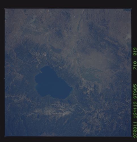
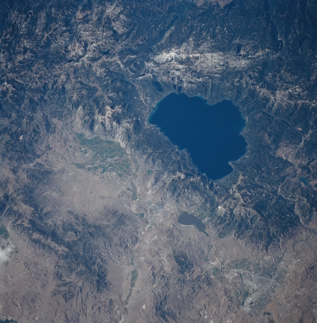
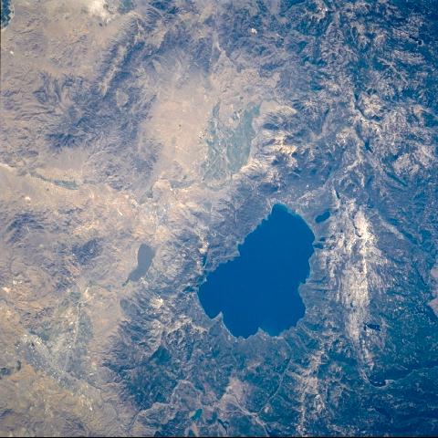
No GeoTIFF is available for this photo.Image Caption: STS085-710-019 Lake Tahoe, California August, 1997
This south-southeast-looking low-oblique synoptic view shows the Lake Tahoe area. Except for the higher steeper peaks of the Sierra Nevada, forests cover most of the right half (western portion) of the image. One of the deepest lakes in North America, Lake Tahoe is visible just to the right of the center of the image. Just east (left) of Lake Tahoe is Lake Washoe. Just to the south of Lake Washoe and barely discernible on the image is the capitol city of Nevada, Carson City. To the south of Carson City and to the south-southeast of Lake Tahoe is the fertile Carson Valley. To the north of Lake Washoe, the cities of Reno and Sparks can be viewed at the bottom left of the image.
This south-southeast-looking low-oblique synoptic view shows the Lake Tahoe area. Except for the higher steeper peaks of the Sierra Nevada, forests cover most of the right half (western portion) of the image. One of the deepest lakes in North America, Lake Tahoe is visible just to the right of the center of the image. Just east (left) of Lake Tahoe is Lake Washoe. Just to the south of Lake Washoe and barely discernible on the image is the capitol city of Nevada, Carson City. To the south of Carson City and to the south-southeast of Lake Tahoe is the fertile Carson Valley. To the north of Lake Washoe, the cities of Reno and Sparks can be viewed at the bottom left of the image.
