< STS085-710-16 >

| NASA Photo ID | STS085-710-16 |
| Focal Length | 100mm |
| Date taken | 1997.08.11 |
| Time taken | 16:43:58 GMT |
Resolutions offered for this image:
794 x 794 pixels 4038 x 4085 pixels 632 x 640 pixels 5700 x 5900 pixels 483 x 500 pixels 514 x 498 pixels 479 x 479 pixels
794 x 794 pixels 4038 x 4085 pixels 632 x 640 pixels 5700 x 5900 pixels 483 x 500 pixels 514 x 498 pixels 479 x 479 pixels


Cloud masks available for this image:
Spacecraft nadir point: 40.3° N, 120.3° W
Photo center point: 39.5° N, 120.0° W
Photo center point by machine learning:
Photo center point: 39.5° N, 120.0° W
Photo center point by machine learning:
Nadir to Photo Center: South
Spacecraft Altitude: 156 nautical miles (289km)
Country or Geographic Name: | USA-NEVADA |
Features: | RENO |
| Features Found Using Machine Learning: | |
Cloud Cover Percentage: | 0 (no clouds present) |
Sun Elevation Angle: | 40° |
Sun Azimuth: | 105° |
Camera: | Hasselblad |
Focal Length: | 100mm |
Camera Tilt: | 18 degrees |
Format: | 5069: Kodak Elite 100S, E6 Reversal, Replaces Lumiere, Warmer in tone vs. Lumiere |
Film Exposure: | Normal |
| Additional Information | |
| Width | Height | Annotated | Cropped | Purpose | Links |
|---|---|---|---|---|---|
| 794 pixels | 794 pixels | No | No | Cities collection | Download Image |
| 4038 pixels | 4085 pixels | No | No | Earth From Space collection | Download Image |
| 632 pixels | 640 pixels | No | No | Earth From Space collection | Download Image |
| 5700 pixels | 5900 pixels | No | No | Download Image Download Color Calibration Image for this Image |
|
| 483 pixels | 500 pixels | No | No | Download Image Download Color Calibration Image for this Image |
|
| 514 pixels | 498 pixels | No | No | Download Image | |
| 479 pixels | 479 pixels | Download Image |
Download Packaged File
Download a Google Earth KML for this Image
View photo footprint information
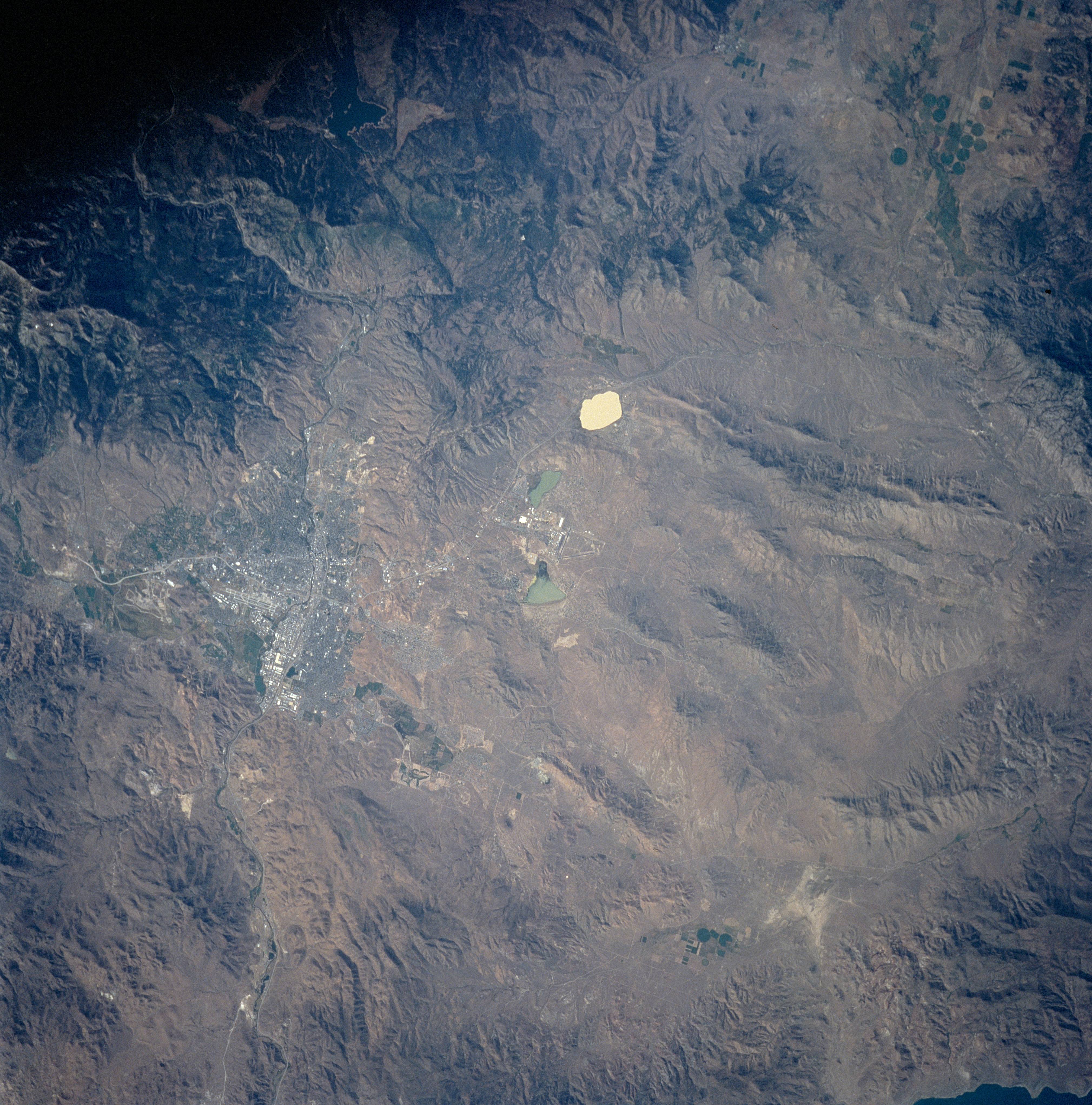
No GeoTIFF is available for this photo.Image Caption: STS085-710-16 Reno, Nevada August, 1997
Situated midway between the center and upper center of the image, the cities of Reno and Sparks, Nevada are visible in this near-vertical view. Located on the Truckee River near the Sierra Nevada, Reno is the second largest city in the state. It produces lumber, cement, electronic components, and is a trade and distribution center for livestock and grain. Reno is an important tourist center in the middle of a vast recreation area, including numerous gambling casinos. The site on which Reno is now located was a popular campsite on the Donner Pass route, across the Sierra Nevada (upper right of the image) to California. The city of Sparks is located just to the east of Reno. Near the center of the image and to the north of Reno are salt-pans and playa-type dry lakes.
Situated midway between the center and upper center of the image, the cities of Reno and Sparks, Nevada are visible in this near-vertical view. Located on the Truckee River near the Sierra Nevada, Reno is the second largest city in the state. It produces lumber, cement, electronic components, and is a trade and distribution center for livestock and grain. Reno is an important tourist center in the middle of a vast recreation area, including numerous gambling casinos. The site on which Reno is now located was a popular campsite on the Donner Pass route, across the Sierra Nevada (upper right of the image) to California. The city of Sparks is located just to the east of Reno. Near the center of the image and to the north of Reno are salt-pans and playa-type dry lakes.
