< STS091-728-15 >
| NASA Photo ID | STS091-728-15 |
| Focal Length | 250mm |
| Date taken | 1998.06.07 |
| Time taken | 00:02:58 GMT |
Resolutions offered for this image:
5700 x 5900 pixels 483 x 500 pixels 2150 x 2030 pixels 639 x 604 pixels
5700 x 5900 pixels 483 x 500 pixels 2150 x 2030 pixels 639 x 604 pixels
Cloud masks available for this image:
Spacecraft nadir point: 40.3° N, 115.8° W
Photo center point: 36.5° N, 112.5° W
Photo center point by machine learning:
Photo center point: 36.5° N, 112.5° W
Photo center point by machine learning:
Nadir to Photo Center: Southeast
Spacecraft Altitude: 196 nautical miles (363km)
Country or Geographic Name: | USA-ARIZONA |
Features: | GRAND CANYON |
| Features Found Using Machine Learning: | |
Cloud Cover Percentage: | 15 (11-25)% |
Sun Elevation Angle: | 33° |
Sun Azimuth: | 273° |
Camera: | Hasselblad |
Focal Length: | 250mm |
Camera Tilt: | Low Oblique |
Format: | 5069: Kodak Elite 100S, E6 Reversal, Replaces Lumiere, Warmer in tone vs. Lumiere |
Film Exposure: | Normal |
| Additional Information | |
| Width | Height | Annotated | Cropped | Purpose | Links |
|---|---|---|---|---|---|
| 5700 pixels | 5900 pixels | No | No | Download Image Download Color Calibration Image for this Image |
|
| 483 pixels | 500 pixels | No | No | Download Image Download Color Calibration Image for this Image |
|
| 2150 pixels | 2030 pixels | Download Image | |||
| 639 pixels | 604 pixels | Download Image |
Download Packaged File
Download a Google Earth KML for this Image
View photo footprint information
No GeoTIFF is available for this photo.Image Caption:
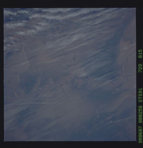
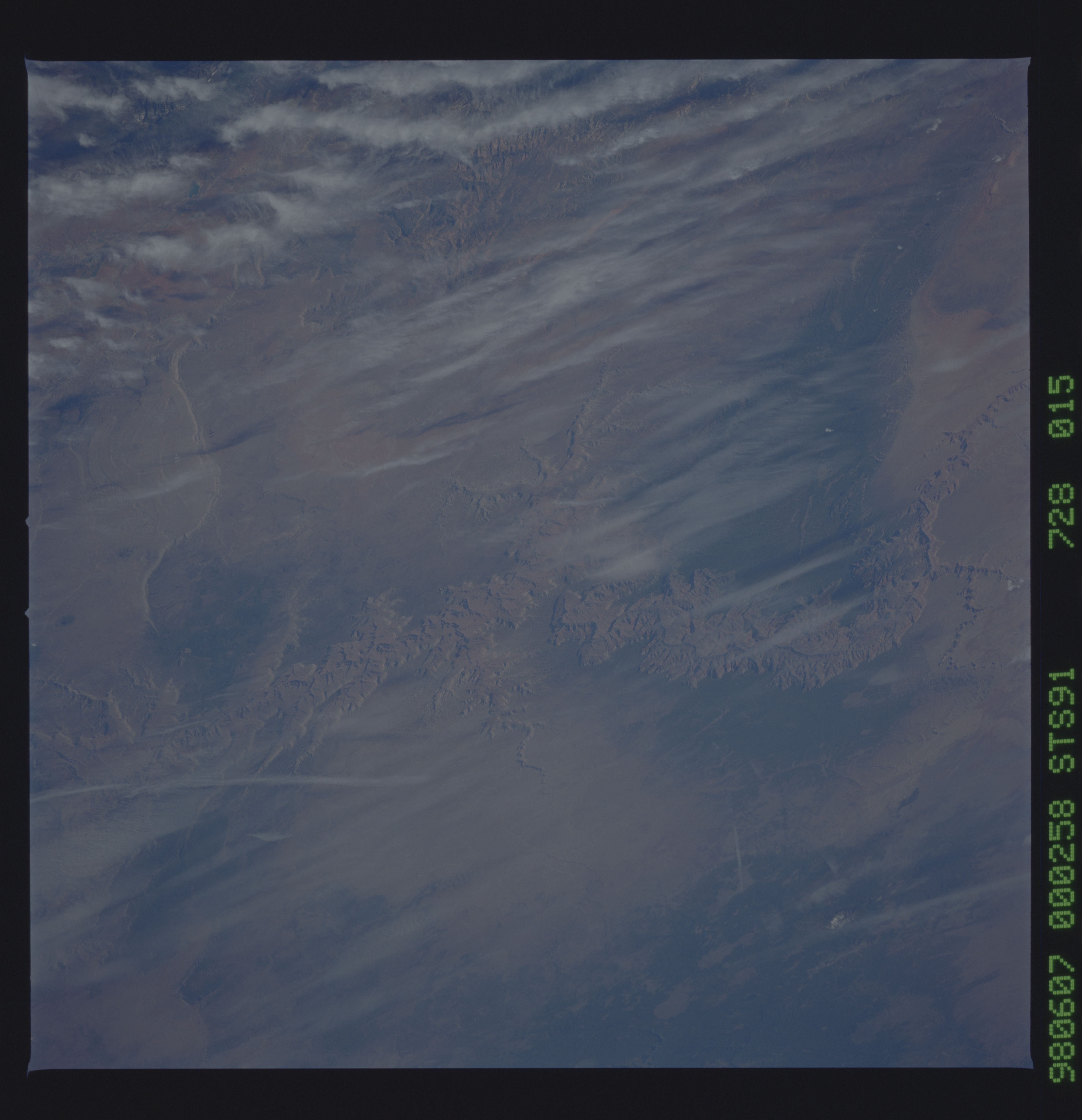
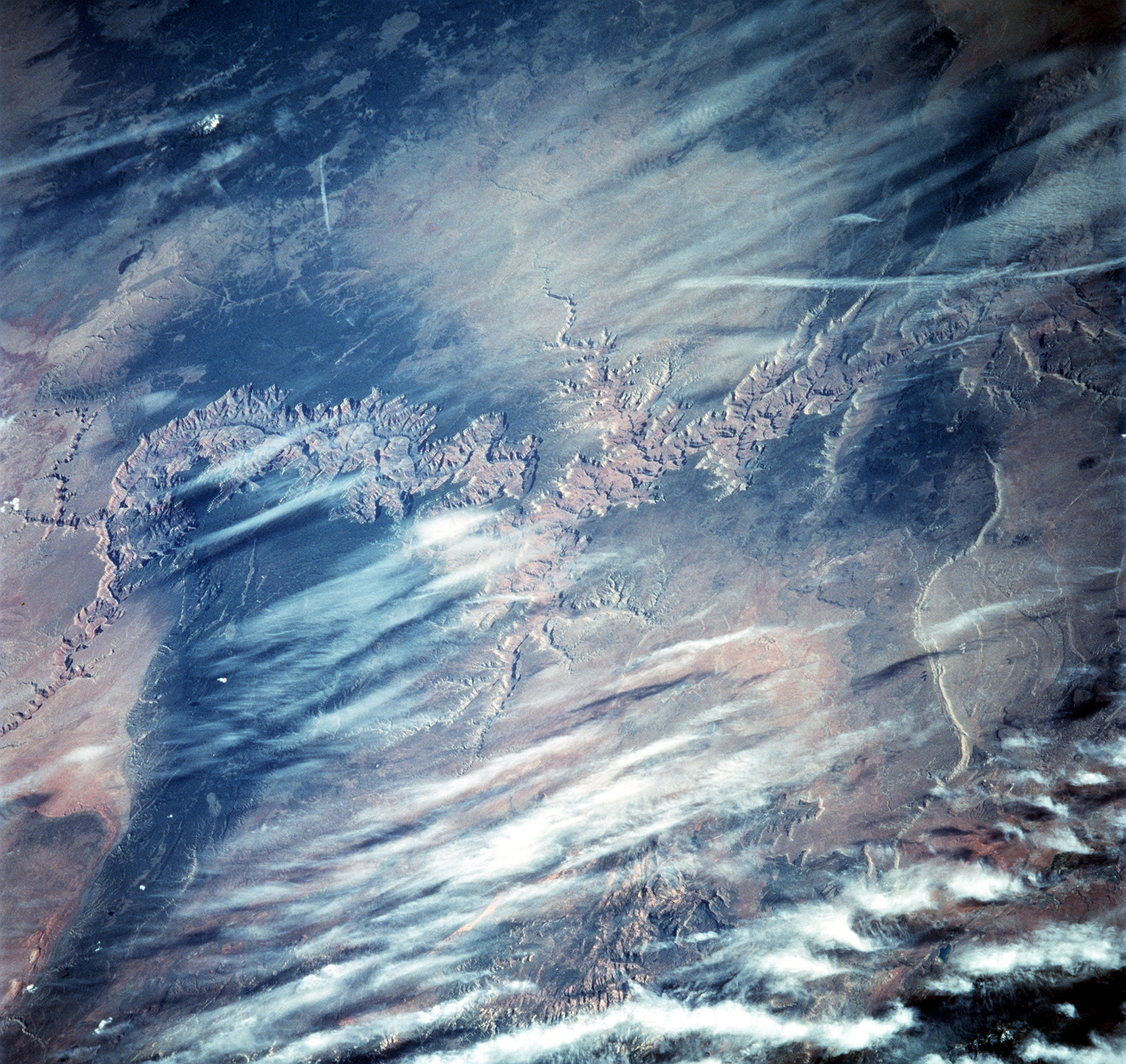
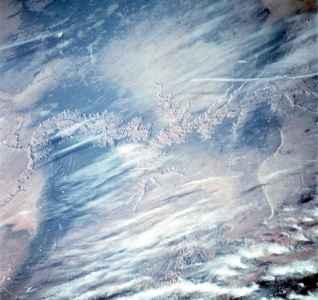
STS091-728-15 Colorado River and the Grand Canyon, Arizona, U.S.A.The Grand Canyon is an immense gorge cut by the Colorado River into the high plateaus of northwestern Arizona, noted for its fantastic shapes and coloration. It ranges in width from about 0.1 to 18 miles (0.2 to 29 km) and extends in a winding course from the mouth of the Paria River, near the northern boundary of Arizona, to Grand Wash Cliffs, near the Nevada line, a distance of about 277 miles (446 km). The deepest and most beautiful section, 56 miles (90 km) long, is within Grand Canyon National Park, which encompasses the river's length from Lake Powell to Lake Mead. At 8,200 feet (2,500 m) above sea level, the North Rim is 1,200 feet (350 m) higher than the South Rim. Grand Canyon National Park, now containing 1,904 square miles (4,931 square km), was created in 1919. The cutting of the mile-deep Grand Canyon by the Colorado River is an event of relatively recent geologic history that began not more than six million years ago, when the river began following its present course. The Colorado River's rapid velocity and large volume and the great amounts of mud, sand, and gravel it carries swiftly downstream account for the incredible cutting capacity of the river. Prior to the building of the Glen Canyon Dam, the sediments carried by the Colorado River were measured at an average of 500,000 tons per day. Conditions favorable to vigorous erosion were brought about by the uplift of the region, which steepened the river's path and allowed deep entrenchment. The depth of the Grand Canyon is due to the cutting action of the river, but its great width is explained by rain, wind, temperature, and chemical erosion, helped by the rapid wear of soft rocks, all of which steadily widened it. Amazingly, the canyon was cut by a reverse process, for the river remained in place and cut through the rocks as the land moved slowly upward against it. Only thus can be explained the canyon's east-to-west course across a south-facing slope and the presence of plateaus that stand across the river's course without having deflected it.
STS091-728-15 Colorado River and the Grand Canyon, Arizona, U.S.A.The Grand Canyon is an immense gorge cut by the Colorado River into the high plateaus of northwestern Arizona, noted for its fantastic shapes and coloration. It ranges in width from about 0.1 to 18 miles (0.2 to 29 km) and extends in a winding course from the mouth of the Paria River, near the northern boundary of Arizona, to Grand Wash Cliffs, near the Nevada line, a distance of about 277 miles (446 km). The deepest and most beautiful section, 56 miles (90 km) long, is within Grand Canyon National Park, which encompasses the river's length from Lake Powell to Lake Mead. At 8,200 feet (2,500 m) above sea level, the North Rim is 1,200 feet (350 m) higher than the South Rim. Grand Canyon National Park, now containing 1,904 square miles (4,931 square km), was created in 1919. The cutting of the mile-deep Grand Canyon by the Colorado River is an event of relatively recent geologic history that began not more than six million years ago, when the river began following its present course. The Colorado River's rapid velocity and large volume and the great amounts of mud, sand, and gravel it carries swiftly downstream account for the incredible cutting capacity of the river. Prior to the building of the Glen Canyon Dam, the sediments carried by the Colorado River were measured at an average of 500,000 tons per day. Conditions favorable to vigorous erosion were brought about by the uplift of the region, which steepened the river's path and allowed deep entrenchment. The depth of the Grand Canyon is due to the cutting action of the river, but its great width is explained by rain, wind, temperature, and chemical erosion, helped by the rapid wear of soft rocks, all of which steadily widened it. Amazingly, the canyon was cut by a reverse process, for the river remained in place and cut through the rocks as the land moved slowly upward against it. Only thus can be explained the canyon's east-to-west course across a south-facing slope and the presence of plateaus that stand across the river's course without having deflected it.
