< STS062-85-147 >
| NASA Photo ID | STS062-85-147 |
| Focal Length | 250mm |
| Date taken | 1994.03.08 |
| Time taken | 17:41:49 GMT |


Cloud masks available for this image:
Spacecraft nadir point: 34.0° N, 86.1° W
Photo center point: 34.0° N, 84.5° W
Photo center point by machine learning:
Photo center point: 34.0° N, 84.5° W
Photo center point by machine learning:
Nadir to Photo Center: East
Spacecraft Altitude: 161 nautical miles (298km)
Camera: | Hasselblad |
Focal Length: | 250mm |
Camera Tilt: | 31 degrees |
Format: | 5046: Kodak, natural color positive, Lumiere 100/5046, ASA 100, standard base |
Film Exposure: | Normal |
| Additional Information | |
| Width | Height | Annotated | Cropped | Purpose | Links |
|---|---|---|---|---|---|
| 5700 pixels | 5900 pixels | No | No | Download Image Download Color Calibration Image for this Image |
|
| 500 pixels | 518 pixels | No | No | Download Image Download Color Calibration Image for this Image |
|
| 640 pixels | 480 pixels | No | No | Download Image |
Download Packaged File
Download a Google Earth KML for this Image
View photo footprint information
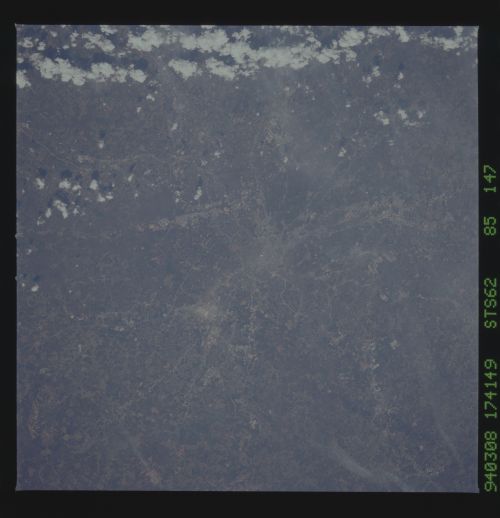
No GeoTIFF is available for this photo.Image Caption: Hartsfield Atlanta International Airport is visible to the south of Atlanta, situated near the center of the photograph. Dobbins Air Force Base and the city of Marietta can also be seen to the north of Atlanta in this south-looking low-oblique view. The complex system of transportation routes and interstate highways surrounding and traversing Atlanta can also be seen in the photograph. The white dot near the center of the photograph is the Georgia Dome, a major sports and entertainment complex in downtown Atlanta. The Stone Mountain Memorial, with its enormous relief carvings of Confederate figures, is located east of Atlanta and is visible on the photograph.
