< ISS016-E-11999 >
| NASA Photo ID | ISS016-E-11999 |
| Focal Length | 400mm |
| Date taken | 2007.11.22 |
| Time taken | 12:52:07 GMT |
Resolutions offered for this image:
1000 x 661 pixels 540 x 357 pixels 540 x 334 pixels 3032 x 2064 pixels 639 x 435 pixels
1000 x 661 pixels 540 x 357 pixels 540 x 334 pixels 3032 x 2064 pixels 639 x 435 pixels


Spacecraft nadir point: 17.2° S, 52.6° W
Photo center point: 18.7° S, 50.4° W
Photo center point by machine learning:
Photo center point: 18.7° S, 50.4° W
Photo center point by machine learning:
Nadir to Photo Center: Southeast
Spacecraft Altitude: 185 nautical miles (343km)
Country or Geographic Name: | BRAZIL |
Features: | SAO SIMAO RES., PARANAIBA R. |
| Features Found Using Machine Learning: | |
Cloud Cover Percentage: | 0 (no clouds present) |
Sun Elevation Angle: | 56° |
Sun Azimuth: | 101° |
Camera: | Kodak DCS760c Electronic Still Camera |
Focal Length: | 400mm |
Camera Tilt: | 41 degrees |
Format: | 3060E: 3060 x 2036 pixel CCD, RGBG array |
Film Exposure: | |
| Additional Information | |
| Width | Height | Annotated | Cropped | Purpose | Links |
|---|---|---|---|---|---|
| 1000 pixels | 661 pixels | No | Yes | Earth From Space collection | Download Image |
| 540 pixels | 357 pixels | Yes | Yes | Earth From Space collection | Download Image |
| 540 pixels | 334 pixels | Yes | Yes | NASA's Earth Observatory web site | Download Image |
| 3032 pixels | 2064 pixels | No | No | Download Image | |
| 639 pixels | 435 pixels | No | No | Download Image |
Download Packaged File
Download a Google Earth KML for this Image
View photo footprint information
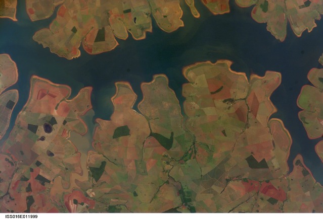
No GeoTIFF is available for this photo.Image Caption: Sao Simao Reservoir, Brazil: 300,000th ISS image of the Earth:
The Sao Simao Reservoir, near the confluence of the Rio Paranaiba and Rio Verde in Brazil, is the featured subject in a milestone image of Earth. This colorful, patchwork image is the 300,000th image of Earth downlinked from the International Space Station (ISS). The astronaut photography collection now includes more than 745,000 images of Earth taken by astronaut crews, beginning with the Mercury missions in 1961 and continuing to the present day on the ISS.
The Sao Simao Reservoir sits at the border between the states of Goias and Minas Gerais (near the geographic coordinates of 18.7 south, 50.4 west). Though the town of Sao Simao was founded around 1935, major growth occurred when the hydroelectric power plant and dam were built in 1975, forming the reservoir. The reservoir is part of a major navigation route that allows transport of goods between central Brazil, the Prata River, and the South Atlantic. With 600,000 square kilometers of surface area, the reservoir is also a tourist destination for fishing, swimming, and boating.
In addition to hydroelectric power production, the economy of the region is based in agribusiness. The image highlights agricultural fields of various kinds and in different stages of cultivation. The major commodities include corn, soybeans, sesame seeds, sugarcane, beans, manioc, coffee, and meat.
