< ISS007-E-11612 >
| NASA Photo ID | ISS007-E-11612 |
| Focal Length | 800mm |
| Date taken | 2003.08.02 |
| Time taken | 00:36:27 GMT |


Spacecraft nadir point: 45.3° N, 117.1° W
Photo center point: 48.5° N, 114.5° W
Photo center point by machine learning:
Photo center point: 48.5° N, 114.5° W
Photo center point by machine learning:
Nadir to Photo Center: Northeast
Spacecraft Altitude: 202 nautical miles (374km)
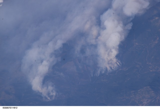
Country or Geographic Name: | USA-MONTANA |
Features: | FOREST FIRE, FLATHEAD RIVER VALLEY |
| Features Found Using Machine Learning: | |
Cloud Cover Percentage: | 50 (26-50)% |
Sun Elevation Angle: | 26° |
Sun Azimuth: | 269° |
Camera: | Kodak DCS760c Electronic Still Camera |
Focal Length: | 800mm |
Camera Tilt: | 51 degrees |
Format: | 3060E: 3060 x 2036 pixel CCD, RGBG array |
Film Exposure: | |
| Additional Information | |
| Width | Height | Annotated | Cropped | Purpose | Links |
|---|---|---|---|---|---|
| 3032 pixels | 2064 pixels | No | No | Download Image | |
| 639 pixels | 435 pixels | No | No | Download Image |
Download Packaged File
Download a Google Earth KML for this Image
View photo footprint information
No GeoTIFF is available for this photo.Image Caption: ISS007-E-11612 (2 August 2003) --- This digital still camera's view of Glacier National Park in Montana, was captured by one of the crew members aboard the International Space Station orbiting earth at 215 nautical miles. The area pictured is north of Flathead Lake on the southern flank of the Apgar Mountains, just across the Flathead River.
