< STS066-154-114 >
| NASA Photo ID | STS066-154-114 |
| Focal Length | 250mm |
| Date taken | 1994.11.07 |
| Time taken | 19:15:47 GMT |

Cloud masks available for this image:
Spacecraft nadir point: 49.7° N, 107.1° W
Photo center point: 51.0° N, 107.5° W
Photo center point by machine learning:
Photo center point: 51.0° N, 107.5° W
Photo center point by machine learning:
Nadir to Photo Center: North
Spacecraft Altitude: 161 nautical miles (298km)
Country or Geographic Name: | CANADA-S |
Features: | SASKATCHEWAN RIVER |
| Features Found Using Machine Learning: | |
Cloud Cover Percentage: | 0 (no clouds present) |
Sun Elevation Angle: | 24° |
Sun Azimuth: | 186° |
Camera: | Linhof |
Focal Length: | 250mm |
Camera Tilt: | 27 degrees |
Format: | 5046: Kodak, natural color positive, Lumiere 100/5046, ASA 100, standard base |
Film Exposure: | Normal |
| Additional Information | |
| Width | Height | Annotated | Cropped | Purpose | Links |
|---|---|---|---|---|---|
| 4096 pixels | 5120 pixels | No | No | Earth From Space collection | Download Image |
| 512 pixels | 640 pixels | No | No | Earth From Space collection | Download Image |
| 640 pixels | 480 pixels | No | No | ISD 1 | Download Image |
Download Packaged File
Download a Google Earth KML for this Image
View photo footprint information
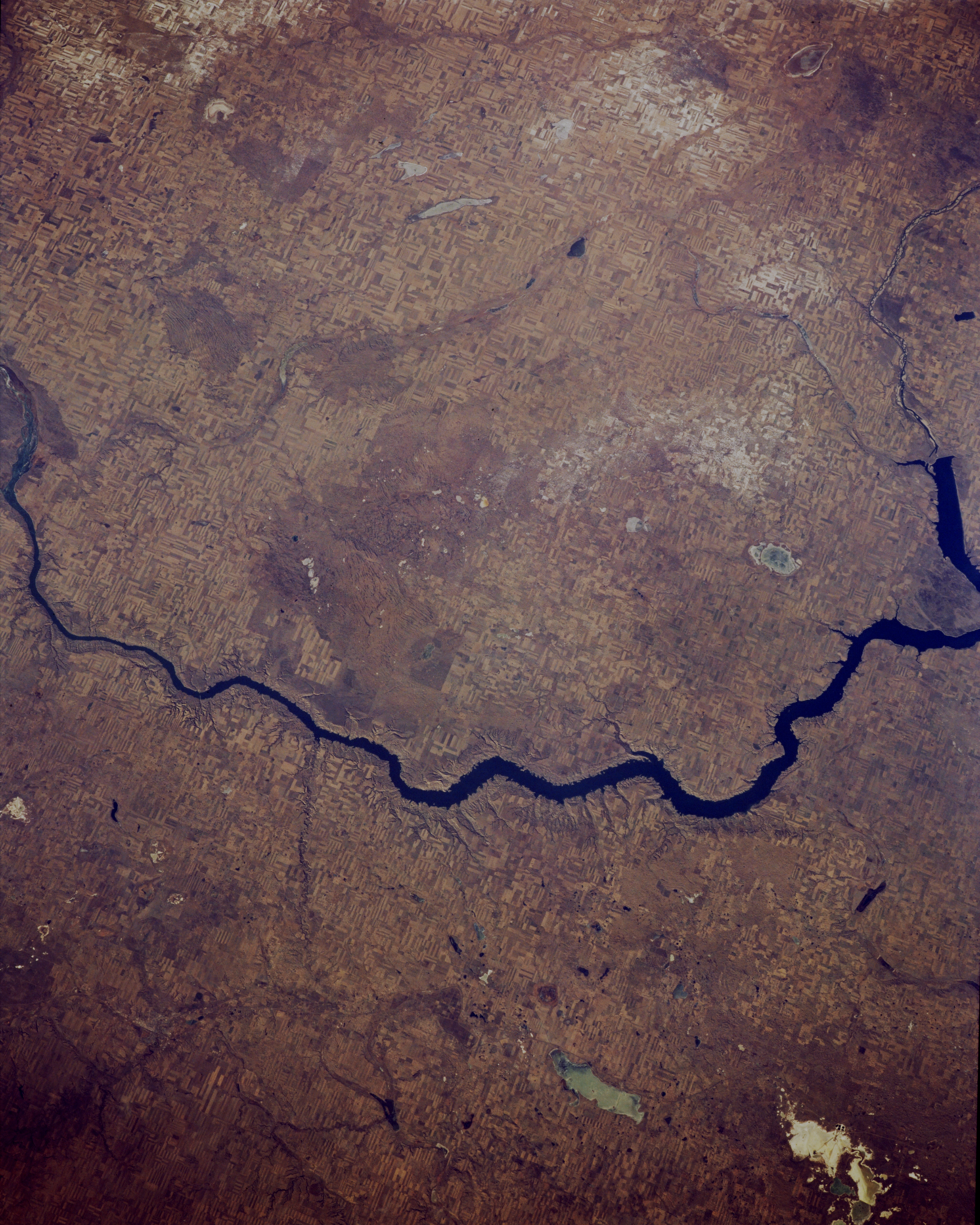
No GeoTIFF is available for this photo.Image Caption: STS066-154-114 South Saskatchewan River, Saskatchewan, Canada November 1994
Lake Diefenbaker, located in southwestern Saskatchewan, is the wide blue sector of the South Saskatchewan River and was created by damming this tributary of the river. One of the dams is located along the center right edge of the picture (abrupt end of the blue lake). Although the agricultural field patterns in this small scale image are not easy to identify, the faint but widespread angular pattern spread across most of the scene represents fence lines aligned diagonally to the edge of the view. The subtle but slightly lighter colored areas north of the South Saskatchewan River suggest a dusting of snow. The grayish feature south of Lake Diefenbaker is Reed Lake (bottom center) and the whitish feature near the lower right corner of the image is Chaplin Lake. Both are dry lakes, indicating the semi-aridity of the Canadian high plains/prairie provinces. A few lakes, such as Luck and Barber, are discernible north of Lake Diefenbaker.
Lake Diefenbaker, located in southwestern Saskatchewan, is the wide blue sector of the South Saskatchewan River and was created by damming this tributary of the river. One of the dams is located along the center right edge of the picture (abrupt end of the blue lake). Although the agricultural field patterns in this small scale image are not easy to identify, the faint but widespread angular pattern spread across most of the scene represents fence lines aligned diagonally to the edge of the view. The subtle but slightly lighter colored areas north of the South Saskatchewan River suggest a dusting of snow. The grayish feature south of Lake Diefenbaker is Reed Lake (bottom center) and the whitish feature near the lower right corner of the image is Chaplin Lake. Both are dry lakes, indicating the semi-aridity of the Canadian high plains/prairie provinces. A few lakes, such as Luck and Barber, are discernible north of Lake Diefenbaker.
